
Station TA D06A - Cle Elum, WA, USA
Network: TA - USArray Transportable Network (new EarthScope stations)
Nearby stations (2 deg radius)
| Station | Name | (Lat, Lon) | Start / End | Elevation |
| D06A | Cle Elum, WA, USA | (47.19, -120.84) | 2006-09-12 / 2499-01-01 | 0.6 km |
| Crust2 Type: | L3,continental arc, Southern Andes, 0.2 km seds. |
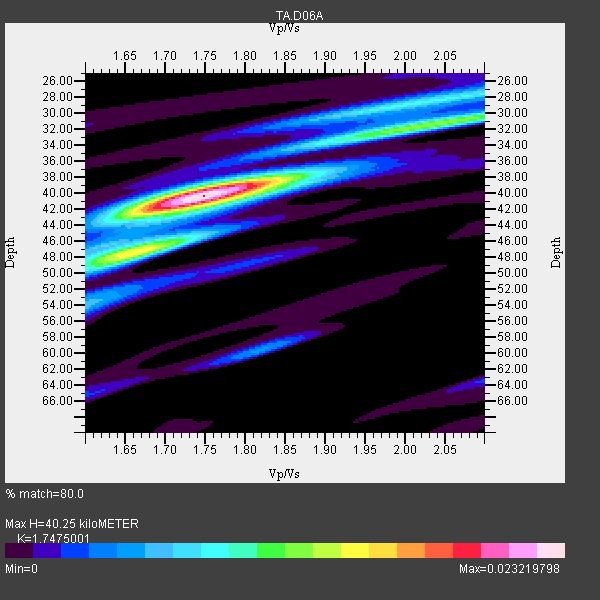
| Thickness Estimate: | 40 km |
| Thickness StdDev: | 3.6 km |
| Vp/Vs Estimate: | 1.75 |
| Vp/Vs StdDev: | 0.09 |
| Vs Estimate: | 3.775 km/s |
| Poisson's Ratio: | 0.26 |
| Peak Value: | 0.02 |
| Assumed Vp: | 6.597 km/s |
| Ps Weight: | 0.33333334 |
| PpPs Weight: | 0.33333334 |
| PsPs Weight: | 0.33333328 |
| Residual Complexity: | 0.530 |
| Nearby stations H: | +- |
| (2.0 deg) Vp/Vs: | +- |
11 with match > 90% ( 24.444445 %) and 29 with match > 80% ( 64.44444 %) out of 45.
Download stack as xyz text file.
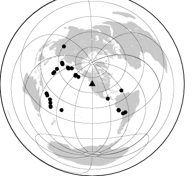
Azimuth Distribution of Events:
Prior Results for this Station
| Study | Thickness | Vp/Vs | Vp | Vs | Poissons Ratio | Extra |
| EARS | 40 km | 1.75 | 6.597 km/s | 3.775 km/s | 0.26 | |
| Crust2.0 | 40 km | 1.77 | 6.597 km/s | 3.723 km/s | 0.27 | L3,continental arc, Southern Andes, 0.2 km seds. |
| Global Maxima | 40 km | 1.75 | 6.597 km/s | 3.775 km/s | 0.26 | amp=0.023219798 |
| Local Maxima 1 | 31 km | 2.05 | 6.597 km/s | 3.222 km/s | 0.34 | amp=0.011927191 |
| Local Maxima 2 | 47 km | 1.69 | 6.597 km/s | 3.915 km/s | 0.23 | amp=0.010980664 |
| Local Maxima 3 | 29 km | 1.98 | 6.597 km/s | 3.341 km/s | 0.33 | amp=0.008018232 |
| Local Maxima 4 | 39 km | 1.76 | 6.597 km/s | 3.743 km/s | 0.26 | amp=0.0065984363 |
| Predicted Arrivals for vertical incidence (zero ray parameter) | |
| Ps | 4.56 SECOND |
| PpPs | 16.76 SECOND |
| PsPs/PpSs | 21.32 SECOND |
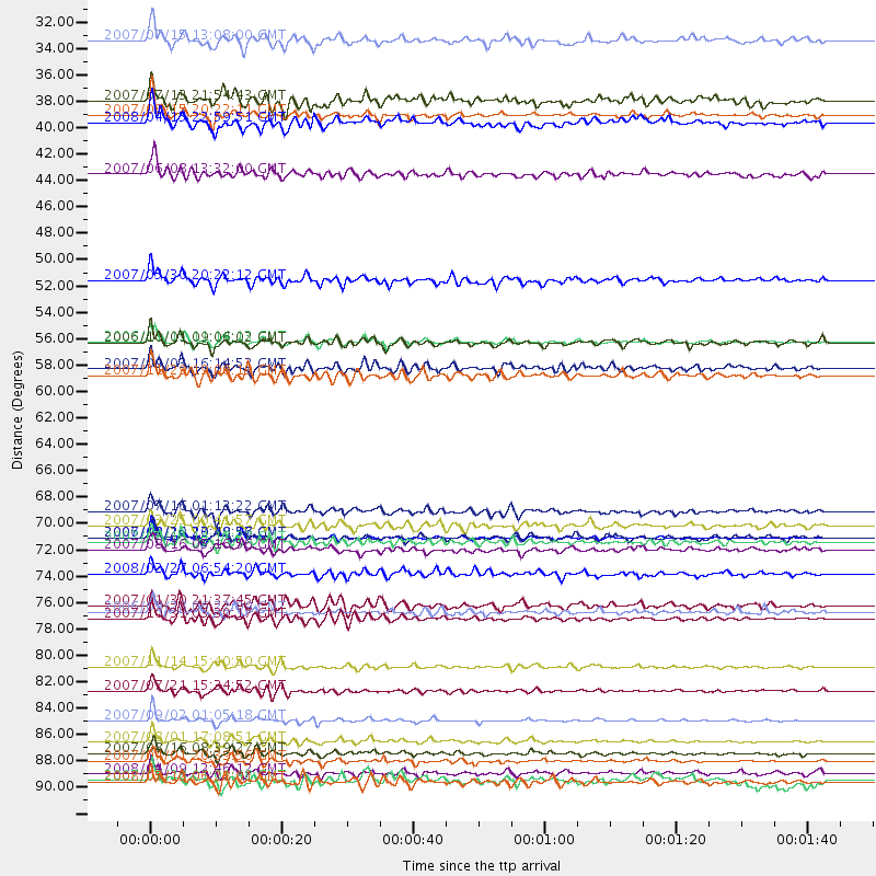
Events Processed for this Station
Download zip of receiver functions as SAC
Plot maxima for each earthquake.
Events Used in the Stack
(29 events)| Radial Match | Distance | Baz | FERegion | Time | Lat/Lon | Depth | Magnitude |
| 97.00457 | 87.4 deg | 250.031 deg | Santa Cruz Islands | 2007/09/02 01:05:18 GMT | (-11.6, 165.8) | 35 km | 5.9 MB, 7.3 MS, 7.2 MW, 6.9 ME |
| 96.353325 | 55.7 deg | 303.641 deg | Kuril Islands | 2006/11/15 11:14:13 GMT | (46.6, 153.3) | 10 km | 6.5 MB, 7.8 MS, 8.3 MW, 7.9 MW |
| 96.23183 | 90.8 deg | 258.522 deg | Solomon Islands | 2007/04/01 20:39:56 GMT | (-8.5, 157.0) | 10 km | 6.8 MB, 7.9 MS, 8.1 MW, 7.7 ME |
| 95.994736 | 72.1 deg | 134.481 deg | Near Coast Of Peru | 2007/08/15 23:40:57 GMT | (-13.4, -76.6) | 39 km | 6.7 MB, 7.9 MS, 8.0 MW, 7.5 ME |
| 93.80283 | 83.0 deg | 133.531 deg | Northern Chile | 2007/11/14 15:40:50 GMT | (-22.2, -69.9) | 40 km | 6.7 MB, 7.4 MS, 7.7 MW, 7.4 ME |
| 92.96341 | 89.2 deg | 246.036 deg | Vanuatu Islands | 2007/08/01 17:08:51 GMT | (-15.6, 167.7) | 120 km | 6.2 MB, 7.2 MW, 7.2 MW |
| 92.67829 | 90.2 deg | 255.836 deg | Solomon Islands | 2007/08/16 08:39:27 GMT | (-9.8, 159.5) | 10 km | 6.1 MB, 6.7 MS, 6.4 MW |
| 91.287315 | 58.6 deg | 102.37 deg | Windward Islands | 2007/11/29 19:00:19 GMT | (15.0, -61.3) | 148 km | 6.9 MB, 7.4 MW, 7.4 MW |
| 91.22356 | 78.3 deg | 229.725 deg | Samoa Islands Region | 2006/09/28 06:22:09 GMT | (-16.6, -172.0) | 28 km | 6.5 MB, 6.6 MS, 6.9 MW, 6.7 MW |
| 90.76147 | 92.6 deg | 323.21 deg | Sichuan, China | 2008/05/12 06:28:01 GMT | (31.0, 103.3) | 19 km | 6.9 MB, 8.1 MS, 7.9 MW, 7.9 MW |
| 90.5911 | 69.9 deg | 303.743 deg | Near West Coast Of Honshu, Japan | 2007/07/16 01:13:22 GMT | (37.5, 138.4) | 12 km | 6.5 MB, 6.4 MS, 6.6 MW, 6.5 MW |
| 89.86185 | 50.5 deg | 307.798 deg | Kamchatka Peninsula, Russia | 2007/05/30 20:22:12 GMT | (52.1, 157.3) | 116 km | 6.4 MB, 6.4 MW, 6.4 MW |
| 89.24943 | 91.9 deg | 242.285 deg | Loyalty Islands | 2008/04/09 12:46:12 GMT | (-20.1, 168.9) | 33 km | 6.3 MB, 7.3 MS, 7.3 MW, 7.3 MW |
| 88.9438 | 78.9 deg | 285.688 deg | Mariana Islands | 2007/10/31 03:30:17 GMT | (18.9, 145.4) | 223 km | 6.2 MB, 7.2 MW, 7.2 MW |
| 88.56337 | 30.5 deg | 297.701 deg | Fox Islands, Aleutian Islands | 2007/07/15 13:08:00 GMT | (52.5, -168.0) | 10 km | 5.8 MB, 5.9 MS, 6.1 MW, 6.0 MW |
| 86.74301 | 58.0 deg | 304.451 deg | Kuril Islands | 2007/09/03 16:14:53 GMT | (45.8, 150.1) | 94 km | 6.3 MB, 6.2 MW, 6.2 ME |
| 86.697334 | 55.8 deg | 303.532 deg | Kuril Islands | 2006/10/01 09:06:02 GMT | (46.5, 153.2) | 19 km | 6.1 MB, 6.4 MS, 6.6 MW, 6.5 MW |
| 85.91677 | 72.5 deg | 305.361 deg | Sea Of Japan | 2007/07/16 14:17:37 GMT | (36.8, 134.9) | 350 km | 6.2 MB, 6.8 MW, 6.8 MW |
| 84.88349 | 85.0 deg | 130.272 deg | Jujuy Province, Argentina | 2007/07/21 15:34:52 GMT | (-22.2, -65.8) | 290 km | 5.8 MB, 6.4 MW, 6.3 MW |
| 84.77755 | 72.1 deg | 134.584 deg | Near Coast Of Peru | 2006/10/20 10:48:56 GMT | (-13.5, -76.7) | 23 km | 5.9 MB, 6.6 MS, 6.7 MW, 6.6 MW |
| 84.18254 | 36.7 deg | 296.409 deg | Andreanof Islands, Aleutian Is. | 2007/08/15 20:22:11 GMT | (50.3, -177.5) | 9.0 km | 6.3 MB, 6.2 MS, 6.4 MW, 5.9 ML |
| 83.00534 | 35.5 deg | 298.498 deg | Andreanof Islands, Aleutian Is. | 2007/07/13 21:54:43 GMT | (51.8, -176.3) | 35 km | 5.7 MB, 5.6 MS, 6.0 MW, 5.9 MW |
| 82.85545 | 41.7 deg | 132.92 deg | Near Coast Of Guatemala | 2007/06/08 13:32:00 GMT | (13.8, -90.8) | 48 km | 5.5 MB, 5.4 MS, 5.8 MW, 5.8 MW |
| 81.873764 | 73.1 deg | 134.529 deg | Near Coast Of Peru | 2007/08/16 05:16:56 GMT | (-14.3, -76.1) | 23 km | 5.8 MB, 6.1 MS, 6.3 MW, 6.2 ML |
| 81.866005 | 77.8 deg | 287.623 deg | Mariana Islands | 2007/01/30 21:37:45 GMT | (21.0, 144.7) | 30 km | 6.3 MB, 6.5 MS, 6.6 MW, 6.5 MW |
| 81.61759 | 37.4 deg | 299.4 deg | Andreanof Islands, Aleutian Is. | 2008/04/15 22:59:51 GMT | (51.9, -179.4) | 10 km | 6.1 MB, 6.4 MS, 6.4 MW, 6.4 MW |
| 81.24363 | 71.1 deg | 304.701 deg | Near West Coast Of Honshu, Japan | 2007/03/25 00:41:57 GMT | (37.3, 136.6) | 8.0 km | 6.1 MB, 6.8 MS, 6.7 MW, 6.6 MW |
| 80.75764 | 75.1 deg | 293.313 deg | Bonin Islands, Japan Region | 2008/02/27 06:54:20 GMT | (26.8, 142.4) | 15 km | 5.8 MB, 6.1 MS, 6.2 MW, 6.2 MW |
| 80.42312 | 92.5 deg | 241.223 deg | Southeast Of Loyalty Islands | 2007/09/28 01:01:48 GMT | (-21.2, 169.4) | 10 km | 5.8 MB, 6.4 MS, 6.3 MW, 6.2 MW |
Losers
(16 events)| Radial Match | Distance | Baz | FERegion | Time | Lat/Lon | Depth | Magnitude | Reason |
| 89.71716 | 84.9 deg | 282.83 deg | South Of Mariana Islands | 2008/05/09 21:51:29 GMT | (12.5, 143.2) | 76 km | 6.1 MB, 6.7 MW, 6.7 MW | |
| 82.33068 | 92.1 deg | 242.225 deg | Loyalty Islands | 2008/04/19 05:58:42 GMT | (-20.3, 168.8) | 14 km | 5.7 MB, 6.2 MS, 6.3 MW, 6.2 MW | |
| 78.150154 | 37.3 deg | 299.382 deg | Andreanof Islands, Aleutian Is. | 2008/04/16 05:54:19 GMT | (51.9, -179.2) | 13 km | 6.1 MB, 6.5 MS, 6.6 MW, 6.6 MW | |
| 75.49051 | 69.1 deg | 300.858 deg | Near East Coast Of Honshu, Japan | 2008/05/07 16:45:20 GMT | (36.2, 141.5) | 39 km | 6.1 MB, 6.7 MS, 6.8 MW, 6.8 MW | |
| 73.824524 | 42.0 deg | 132.919 deg | Near Coast Of Guatemala | 2008/04/15 03:03:04 GMT | (13.6, -90.6) | 33 km | 5.6 MB, 5.8 MS, 6.1 MW, 6.1 MW | |
| 73.56891 | 92.0 deg | 242.202 deg | Loyalty Islands | 2008/04/09 11:23:40 GMT | (-20.2, 168.9) | 35 km | 5.7 MB, 6.3 MW, 6.3 MW | |
| 68.57743 | 91.8 deg | 242.324 deg | Vanuatu Islands | 2008/04/28 18:33:34 GMT | (-19.9, 169.0) | 32 km | 6.2 MB, 6.2 MS, 6.4 MW, 6.4 MW | |
| 67.78901 | 92.2 deg | 242.125 deg | Loyalty Islands | 2008/04/11 17:45:05 GMT | (-20.4, 168.8) | 35 km | 5.7 MB, 5.9 MS, 6.0 MW, 6.0 MW | |
| 66.43201 | 92.0 deg | 242.241 deg | Loyalty Islands | 2008/04/09 11:13:17 GMT | (-20.2, 168.9) | 13 km | 5.6 MB, 6.3 MS, 6.4 MW, 6.3 MW | |
| 60.828026 | 92.1 deg | 242.084 deg | Loyalty Islands | 2008/04/10 01:10:02 GMT | (-20.3, 168.9) | 35 km | 5.5 MB, 5.5 MS, 5.8 MW | |
| 57.825226 | 95.6 deg | 296.277 deg | Philippine Islands Region | 2008/03/03 14:11:14 GMT | (13.4, 125.6) | 24 km | 6.4 MB, 6.9 MW, 6.8 MW | |
| 54.67668 | 69.1 deg | 300.859 deg | Near East Coast Of Honshu, Japan | 2008/05/07 16:02:02 GMT | (36.2, 141.5) | 19 km | 5.7 MB, 6.2 MW, 6.2 MW | |
| 54.021706 | 92.1 deg | 242.227 deg | Loyalty Islands | 2008/04/28 20:26:53 GMT | (-20.2, 168.8) | 35 km | 5.8 MB, 5.7 MS, 6.1 MW, 6.0 MW | |
| 50.865875 | 82.7 deg | 234.899 deg | Fiji Islands Region | 2008/04/18 20:39:07 GMT | (-17.3, -179.0) | 554 km | 5.9 MB, 6.3 MW, 6.3 MW | |
| 48.55829 | 69.1 deg | 300.722 deg | Near East Coast Of Honshu, Japan | 2008/05/08 23:21:06 GMT | (36.1, 141.7) | 17 km | 5.6 MB, 5.2 MS, 5.6 MW, 5.5 MW | |
| 47.01818 | 68.0 deg | 303.98 deg | Eastern Honshu, Japan | 2008/04/16 19:19:36 GMT | (39.0, 140.0) | 166 km | 5.6 MB, 5.8 MW, 5.8 MW |
