You are here: Home > Network List > TA - USArray Transportable Network (new EarthScope stations) Stations List
> Station D06A Cle Elum, WA, USA > Earthquake Result Viewer
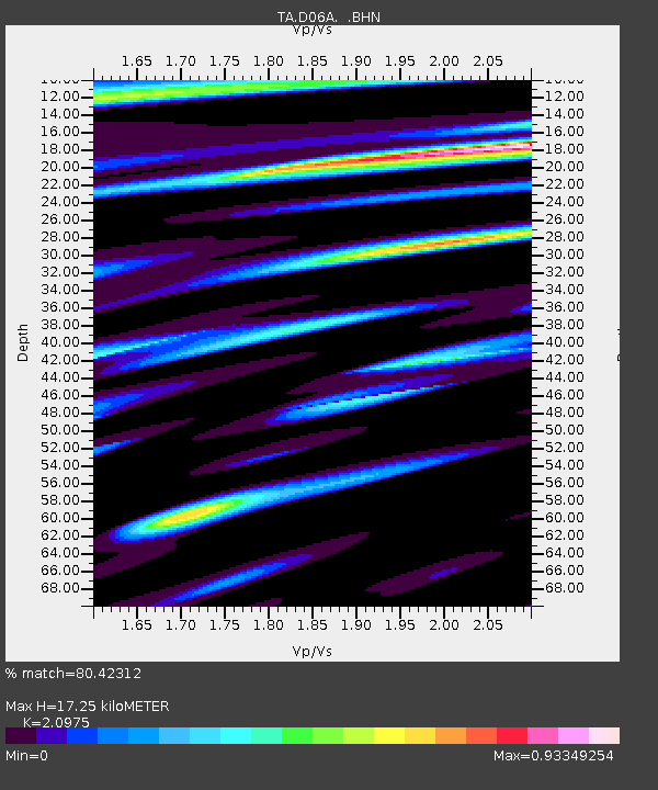
D06A Cle Elum, WA, USA - Earthquake Result Viewer
| Earthquake location: |
Southeast Of Loyalty Islands |
| Earthquake latitude/longitude: |
-21.2/169.4 |
| Earthquake time(UTC): |
2007/09/28 (271) 01:01:48 GMT |
| Earthquake Depth: |
10 km |
| Earthquake Magnitude: |
5.8 MB, 6.4 MS, 6.3 MW, 6.2 MW |
| Earthquake Catalog/Contributor: |
WHDF/NEIC |
|
| Network: |
TA USArray Transportable Network (new EarthScope stations) |
| Station: |
D06A Cle Elum, WA, USA |
| Lat/Lon: |
47.19 N/120.84 W |
| Elevation: |
575 m |
|
| Distance: |
92.5 deg |
| Az: |
39.837 deg |
| Baz: |
241.223 deg |
| Ray Param: |
0.04145086 |
| Estimated Moho Depth: |
17.25 km |
| Estimated Crust Vp/Vs: |
2.10 |
| Assumed Crust Vp: |
6.597 km/s |
| Estimated Crust Vs: |
3.145 km/s |
| Estimated Crust Poisson's Ratio: |
0.35 |
|
| Radial Match: |
80.42312 % |
| Radial Bump: |
400 |
| Transverse Match: |
64.50388 % |
| Transverse Bump: |
400 |
| SOD ConfigId: |
2564 |
| Insert Time: |
2010-03-07 02:52:50.431 +0000 |
| GWidth: |
2.5 |
| Max Bumps: |
400 |
| Tol: |
0.001 |
|

Signal To Noise
| Channel | StoN | STA | LTA |
| TA:D06A: :BHN:20070928T01:14:28.300012Z | 0.43082482 | 1.3558532E-7 | 3.1471103E-7 |
| TA:D06A: :BHE:20070928T01:14:28.300012Z | 1.2953384 | 2.2906084E-7 | 1.7683476E-7 |
| TA:D06A: :BHZ:20070928T01:14:28.300012Z | 4.528143 | 4.74982E-7 | 1.0489554E-7 |
| Arrivals |
| Ps | 2.9 SECOND |
| PpPs | 8.0 SECOND |
| PsPs/PpSs | 11 SECOND |


