You are here: Home > Network List > TA - USArray Transportable Network (new EarthScope stations) Stations List
> Station D06A Cle Elum, WA, USA > Earthquake Result Viewer
D06A Cle Elum, WA, USA - Earthquake Result Viewer
| Earthquake location: |
Near Coast Of Peru |
| Earthquake latitude/longitude: |
-14.3/-76.1 |
| Earthquake time(UTC): |
2007/08/16 (228) 05:16:56 GMT |
| Earthquake Depth: |
23 km |
| Earthquake Magnitude: |
5.8 MB, 6.1 MS, 6.3 MW, 6.2 ML |
| Earthquake Catalog/Contributor: |
WHDF/NEIC |
|
| Network: |
TA USArray Transportable Network (new EarthScope stations) |
| Station: |
D06A Cle Elum, WA, USA |
| Lat/Lon: |
47.19 N/120.84 W |
| Elevation: |
575 m |
|
| Distance: |
73.1 deg |
| Az: |
329.902 deg |
| Baz: |
134.529 deg |
| Ray Param: |
0.05319262 |
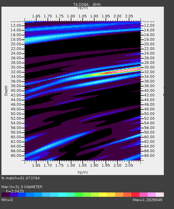
| Estimated Moho Depth: |
31.0 km |
| Estimated Crust Vp/Vs: |
2.04 |
| Assumed Crust Vp: |
6.597 km/s |
| Estimated Crust Vs: |
3.23 km/s |
| Estimated Crust Poisson's Ratio: |
0.34 |
|
| Radial Match: |
81.873764 % |
| Radial Bump: |
400 |
| Transverse Match: |
74.32492 % |
| Transverse Bump: |
400 |
| SOD ConfigId: |
2564 |
| Insert Time: |
2010-03-07 02:52:57.075 +0000 |
| GWidth: |
2.5 |
| Max Bumps: |
400 |
| Tol: |
0.001 |
|

Signal To Noise
| Channel | StoN | STA | LTA |
| TA:D06A: :BHN:20070816T05:27:53.324011Z | 1.7385769 | 2.4052946E-7 | 1.3834848E-7 |
| TA:D06A: :BHE:20070816T05:27:53.324011Z | 0.7027877 | 1.3312436E-7 | 1.8942329E-7 |
| TA:D06A: :BHZ:20070816T05:27:53.324011Z | 3.7772129 | 5.32502E-7 | 1.4097749E-7 |
| Arrivals |
| Ps | 5.1 SECOND |
| PpPs | 14 SECOND |
| PsPs/PpSs | 19 SECOND |


