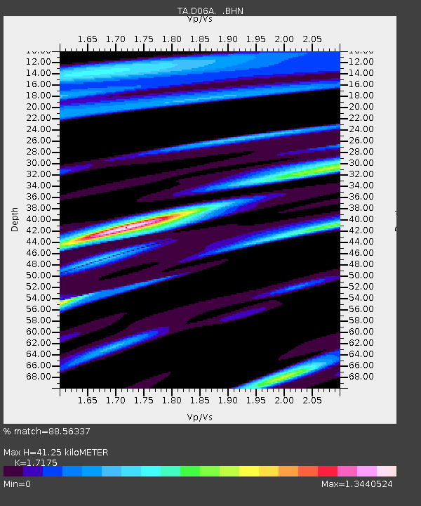
D06A Cle Elum, WA, USA - Earthquake Result Viewer
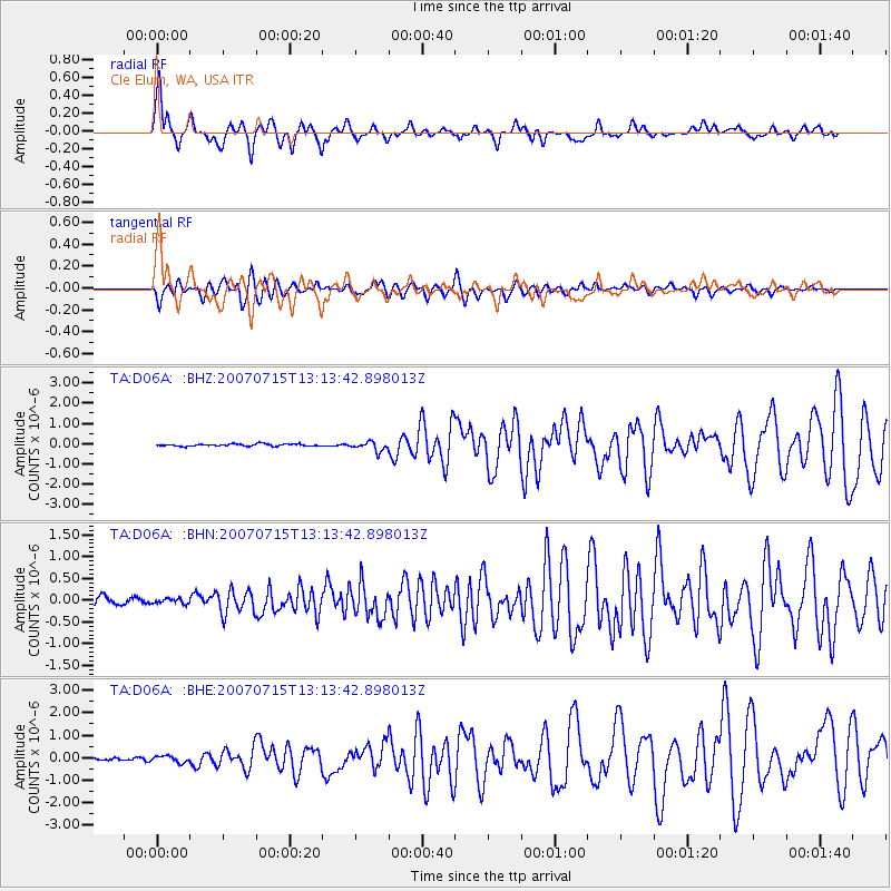
Earthquake location: Fox Islands, Aleutian Islands
Earthquake latitude/longitude: 52.5/-168.0
Earthquake time(UTC): 2007/07/15 (196) 13:08:00 GMT
Earthquake Depth: 10 km
Earthquake Magnitude: 5.8 MB, 5.9 MS, 6.1 MW, 6.0 MW
Earthquake Catalog/Contributor: WHDF/NEIC
Network: TA USArray Transportable Network (new EarthScope stations)
Station: D06A Cle Elum, WA, USA
Lat/Lon: 47.19 N/120.84 W
Elevation: 575 m
Distance: 30.5 deg
Az: 80.833 deg
Baz: 297.701 deg
Ray Param: 0.07932725
Estimated Moho Depth: 41.25 km
Estimated Crust Vp/Vs: 1.72
Assumed Crust Vp: 6.597 km/s
Estimated Crust Vs: 3.841 km/s
Estimated Crust Poisson's Ratio: 0.24
Radial Match: 88.56337 %
Radial Bump: 400
Transverse Match: 76.54279 %
Transverse Bump: 400
SOD ConfigId: 2564
Insert Time: 2010-03-07 02:53:08.937 +0000
GWidth: 2.5
Max Bumps: 400
Tol: 0.001

Signal To Noise

ChannelStoNSTALTA
TA:D06A: :BHN:20070715T13:13:42.898013Z0.58702425.85479E-89.973677E-8
TA:D06A: :BHE:20070715T13:13:42.898013Z1.52472811.4481832E-79.497977E-8
TA:D06A: :BHZ:20070715T13:13:42.898013Z4.26398562.2879688E-75.3657985E-8
Arrivals
Ps4.9 SECOND
PpPs16 SECOND
PsPs/PpSs20 SECOND