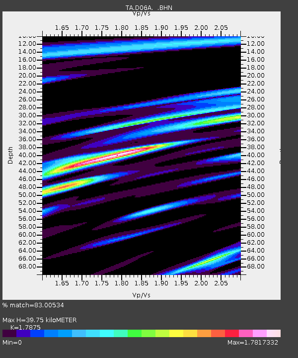
D06A Cle Elum, WA, USA - Earthquake Result Viewer
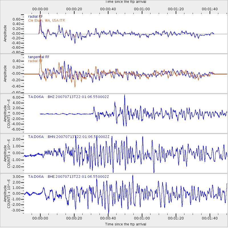
Earthquake location: Andreanof Islands, Aleutian Is.
Earthquake latitude/longitude: 51.8/-176.3
Earthquake time(UTC): 2007/07/13 (194) 21:54:43 GMT
Earthquake Depth: 35 km
Earthquake Magnitude: 5.7 MB, 5.6 MS, 6.0 MW, 5.9 MW
Earthquake Catalog/Contributor: WHDF/NEIC
Network: TA USArray Transportable Network (new EarthScope stations)
Station: D06A Cle Elum, WA, USA
Lat/Lon: 47.19 N/120.84 W
Elevation: 575 m
Distance: 35.5 deg
Az: 75.012 deg
Baz: 298.498 deg
Ray Param: 0.07709754
Estimated Moho Depth: 39.75 km
Estimated Crust Vp/Vs: 1.79
Assumed Crust Vp: 6.597 km/s
Estimated Crust Vs: 3.691 km/s
Estimated Crust Poisson's Ratio: 0.27
Radial Match: 83.00534 %
Radial Bump: 400
Transverse Match: 81.825775 %
Transverse Bump: 400
SOD ConfigId: 2564
Insert Time: 2010-03-07 02:53:11.037 +0000
GWidth: 2.5
Max Bumps: 400
Tol: 0.001

Signal To Noise

ChannelStoNSTALTA
TA:D06A: :BHN:20070713T22:01:06.550002Z1.65872312.5768733E-71.5535284E-7
TA:D06A: :BHE:20070713T22:01:06.550002Z4.74049665.680834E-71.1983627E-7
TA:D06A: :BHZ:20070713T22:01:06.550002Z11.5025011.1226073E-69.75968E-8
Arrivals
Ps5.1 SECOND
PpPs16 SECOND
PsPs/PpSs21 SECOND