You are here: Home > Network List > TA - USArray Transportable Network (new EarthScope stations) Stations List
> Station D06A Cle Elum, WA, USA > Earthquake Result Viewer
D06A Cle Elum, WA, USA - Earthquake Result Viewer
| Earthquake location: |
Near Coast Of Guatemala |
| Earthquake latitude/longitude: |
13.8/-90.8 |
| Earthquake time(UTC): |
2007/06/08 (159) 13:32:00 GMT |
| Earthquake Depth: |
48 km |
| Earthquake Magnitude: |
5.5 MB, 5.4 MS, 5.8 MW, 5.8 MW |
| Earthquake Catalog/Contributor: |
WHDF/NEIC |
|
| Network: |
TA USArray Transportable Network (new EarthScope stations) |
| Station: |
D06A Cle Elum, WA, USA |
| Lat/Lon: |
47.19 N/120.84 W |
| Elevation: |
575 m |
|
| Distance: |
41.7 deg |
| Az: |
329.06 deg |
| Baz: |
132.92 deg |
| Ray Param: |
0.0735183 |
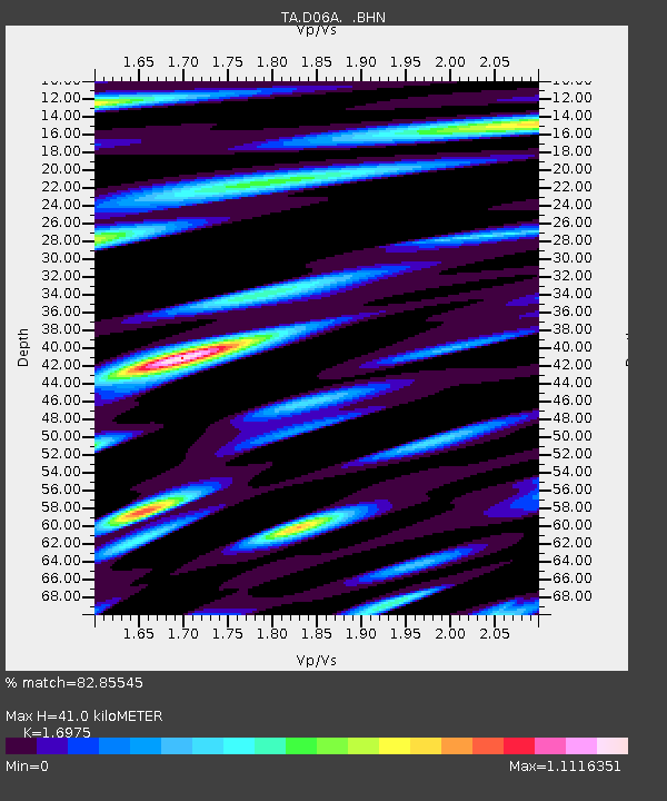
| Estimated Moho Depth: |
41.0 km |
| Estimated Crust Vp/Vs: |
1.70 |
| Assumed Crust Vp: |
6.597 km/s |
| Estimated Crust Vs: |
3.887 km/s |
| Estimated Crust Poisson's Ratio: |
0.23 |
|
| Radial Match: |
82.85545 % |
| Radial Bump: |
400 |
| Transverse Match: |
70.188835 % |
| Transverse Bump: |
400 |
| SOD ConfigId: |
2564 |
| Insert Time: |
2010-03-07 02:53:12.685 +0000 |
| GWidth: |
2.5 |
| Max Bumps: |
400 |
| Tol: |
0.001 |
|

Signal To Noise
| Channel | StoN | STA | LTA |
| TA:D06A: :BHN:20070608T13:39:14.173015Z | 2.2549024 | 2.5548627E-7 | 1.1330259E-7 |
| TA:D06A: :BHE:20070608T13:39:14.173015Z | 2.9384894 | 3.540555E-7 | 1.2048893E-7 |
| TA:D06A: :BHZ:20070608T13:39:14.173015Z | 9.540268 | 7.391431E-7 | 7.747614E-8 |
| Arrivals |
| Ps | 4.7 SECOND |
| PpPs | 16 SECOND |
| PsPs/PpSs | 20 SECOND |


