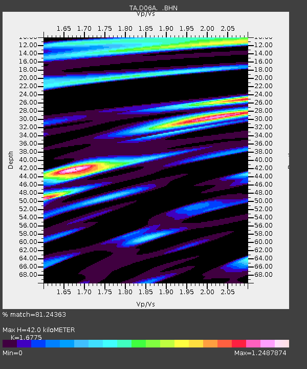
D06A Cle Elum, WA, USA - Earthquake Result Viewer
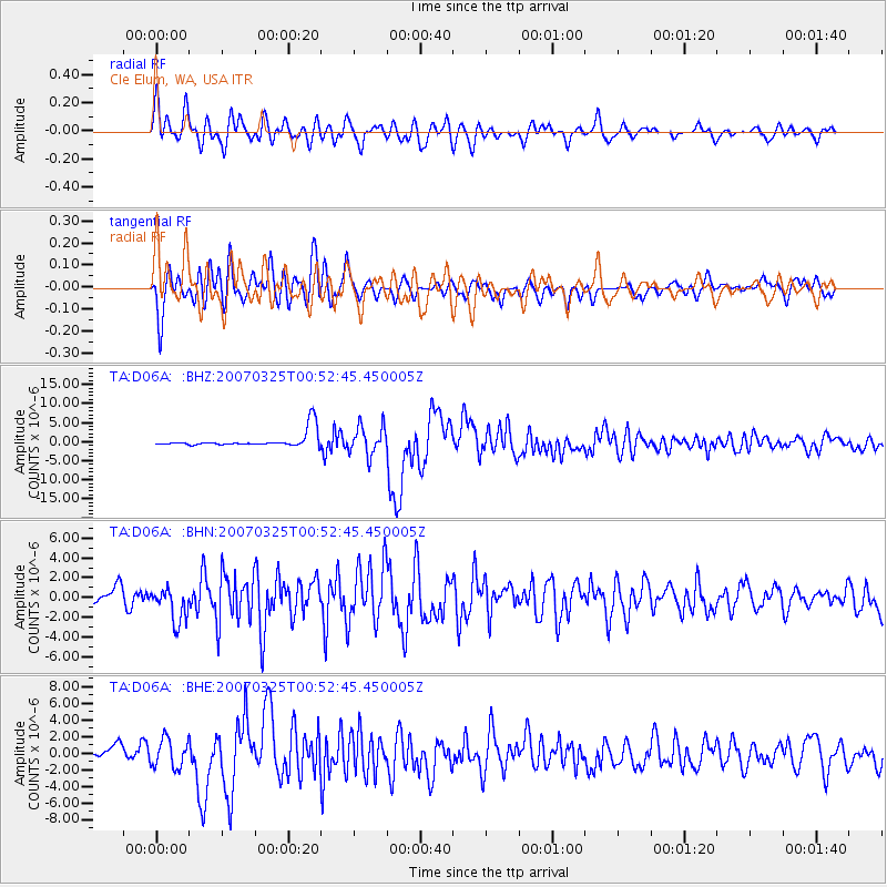
Earthquake location: Near West Coast Of Honshu, Japan
Earthquake latitude/longitude: 37.3/136.6
Earthquake time(UTC): 2007/03/25 (084) 00:41:57 GMT
Earthquake Depth: 8.0 km
Earthquake Magnitude: 6.1 MB, 6.8 MS, 6.7 MW, 6.6 MW
Earthquake Catalog/Contributor: WHDF/NEIC
Network: TA USArray Transportable Network (new EarthScope stations)
Station: D06A Cle Elum, WA, USA
Lat/Lon: 47.19 N/120.84 W
Elevation: 575 m
Distance: 71.1 deg
Az: 44.704 deg
Baz: 304.701 deg
Ray Param: 0.054527607
Estimated Moho Depth: 42.0 km
Estimated Crust Vp/Vs: 1.68
Assumed Crust Vp: 6.597 km/s
Estimated Crust Vs: 3.933 km/s
Estimated Crust Poisson's Ratio: 0.22
Radial Match: 81.24363 %
Radial Bump: 400
Transverse Match: 75.491356 %
Transverse Bump: 400
SOD ConfigId: 2564
Insert Time: 2010-03-07 02:53:17.813 +0000
GWidth: 2.5
Max Bumps: 400
Tol: 0.001

Signal To Noise

ChannelStoNSTALTA
TA:D06A: :BHN:20070325T00:52:45.450005Z3.41480331.7449562E-65.109976E-7
TA:D06A: :BHE:20070325T00:52:45.450005Z3.24719951.692138E-65.2110687E-7
TA:D06A: :BHZ:20070325T00:52:45.450005Z1.90888663.7207942E-61.949196E-6
Arrivals
Ps4.5 SECOND
PpPs16 SECOND
PsPs/PpSs21 SECOND