You are here: Home > Network List > TA - USArray Transportable Network (new EarthScope stations) Stations List
> Station D06A Cle Elum, WA, USA > Earthquake Result Viewer
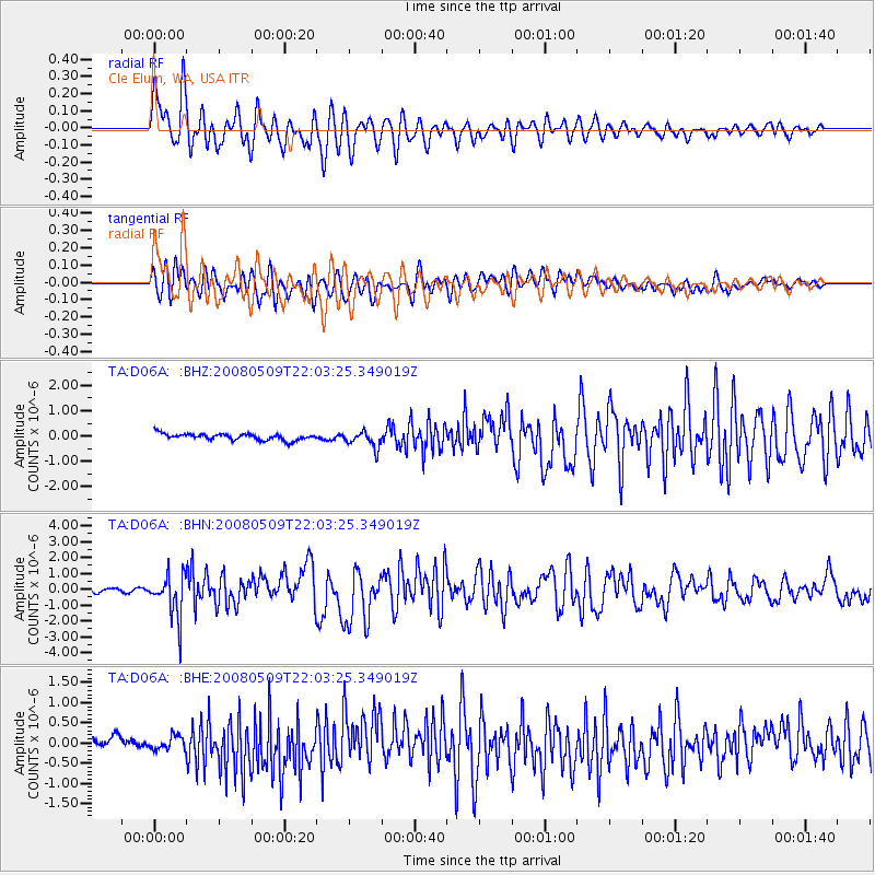
D06A Cle Elum, WA, USA - Earthquake Result Viewer
*The percent match for this event was below the threshold and hence no stack was calculated.
| Earthquake location: |
South Of Mariana Islands |
| Earthquake latitude/longitude: |
12.5/143.2 |
| Earthquake time(UTC): |
2008/05/09 (130) 21:51:29 GMT |
| Earthquake Depth: |
76 km |
| Earthquake Magnitude: |
6.1 MB, 6.7 MW, 6.7 MW |
| Earthquake Catalog/Contributor: |
WHDF/NEIC |
|
| Network: |
TA USArray Transportable Network (new EarthScope stations) |
| Station: |
D06A Cle Elum, WA, USA |
| Lat/Lon: |
47.19 N/120.84 W |
| Elevation: |
575 m |
|
| Distance: |
84.9 deg |
| Az: |
42.916 deg |
| Baz: |
282.83 deg |
| Ray Param: |
$rayparam |
*The percent match for this event was below the threshold and hence was not used in the summary stack. |
|
| Radial Match: |
89.71716 % |
| Radial Bump: |
400 |
| Transverse Match: |
73.2971 % |
| Transverse Bump: |
400 |
| SOD ConfigId: |
2504 |
| Insert Time: |
2010-03-07 02:53:53.490 +0000 |
| GWidth: |
2.5 |
| Max Bumps: |
400 |
| Tol: |
0.001 |
|
Signal To Noise
| Channel | StoN | STA | LTA |
| TA:D06A: :BHN:20080509T22:03:25.349019Z | 11.285066 | 1.336162E-6 | 1.184009E-7 |
| TA:D06A: :BHE:20080509T22:03:25.349019Z | 0.87370914 | 1.7761361E-7 | 2.0328689E-7 |
| TA:D06A: :BHZ:20080509T22:03:25.349019Z | 2.5432863 | 3.2727962E-7 | 1.2868375E-7 |
| Arrivals |
| Ps | |
| PpPs | |
| PsPs/PpSs | |


