You are here: Home > Network List > TA - USArray Transportable Network (new EarthScope stations) Stations List
> Station D06A Cle Elum, WA, USA > Earthquake Result Viewer
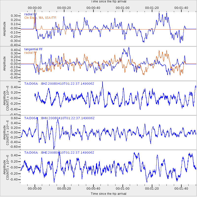
D06A Cle Elum, WA, USA - Earthquake Result Viewer
*The percent match for this event was below the threshold and hence no stack was calculated.
| Earthquake location: |
Loyalty Islands |
| Earthquake latitude/longitude: |
-20.3/168.9 |
| Earthquake time(UTC): |
2008/04/10 (101) 01:10:02 GMT |
| Earthquake Depth: |
35 km |
| Earthquake Magnitude: |
5.5 MB, 5.5 MS, 5.8 MW |
| Earthquake Catalog/Contributor: |
WHDF/NEIC |
|
| Network: |
TA USArray Transportable Network (new EarthScope stations) |
| Station: |
D06A Cle Elum, WA, USA |
| Lat/Lon: |
47.19 N/120.84 W |
| Elevation: |
575 m |
|
| Distance: |
92.1 deg |
| Az: |
39.952 deg |
| Baz: |
242.084 deg |
| Ray Param: |
$rayparam |
*The percent match for this event was below the threshold and hence was not used in the summary stack. |
|
| Radial Match: |
60.828026 % |
| Radial Bump: |
400 |
| Transverse Match: |
57.06757 % |
| Transverse Bump: |
400 |
| SOD ConfigId: |
2504 |
| Insert Time: |
2010-03-07 02:53:54.122 +0000 |
| GWidth: |
2.5 |
| Max Bumps: |
400 |
| Tol: |
0.001 |
|
Signal To Noise
| Channel | StoN | STA | LTA |
| TA:D06A: :BHN:20080410T01:22:37.149006Z | 3.1154096 | 2.8460016E-7 | 9.1352405E-8 |
| TA:D06A: :BHE:20080410T01:22:37.149006Z | 0.6355528 | 1.2138891E-7 | 1.9099735E-7 |
| TA:D06A: :BHZ:20080410T01:22:37.149006Z | 0.62368035 | 9.073473E-8 | 1.4548276E-7 |
| Arrivals |
| Ps | |
| PpPs | |
| PsPs/PpSs | |


