You are here: Home > Network List > TA - USArray Transportable Network (new EarthScope stations) Stations List
> Station B07A Winthrop, WA, USA > Earthquake Result Viewer
B07A Winthrop, WA, USA - Earthquake Result Viewer
| Earthquake location: |
Andreanof Islands, Aleutian Is. |
| Earthquake latitude/longitude: |
51.4/-179.0 |
| Earthquake time(UTC): |
2007/12/21 (355) 07:24:34 GMT |
| Earthquake Depth: |
30 km |
| Earthquake Magnitude: |
6.1 MB, 6.2 MW, 6.3 ML |
| Earthquake Catalog/Contributor: |
WHDF/NEIC |
|
| Network: |
TA USArray Transportable Network (new EarthScope stations) |
| Station: |
B07A Winthrop, WA, USA |
| Lat/Lon: |
48.46 N/120.12 W |
| Elevation: |
781 m |
|
| Distance: |
37.1 deg |
| Az: |
70.679 deg |
| Baz: |
297.263 deg |
| Ray Param: |
0.076248586 |
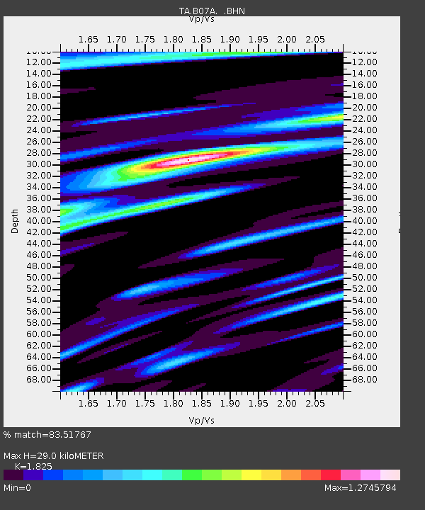
| Estimated Moho Depth: |
29.0 km |
| Estimated Crust Vp/Vs: |
1.83 |
| Assumed Crust Vp: |
6.566 km/s |
| Estimated Crust Vs: |
3.598 km/s |
| Estimated Crust Poisson's Ratio: |
0.29 |
|
| Radial Match: |
83.51767 % |
| Radial Bump: |
400 |
| Transverse Match: |
73.95616 % |
| Transverse Bump: |
400 |
| SOD ConfigId: |
2564 |
| Insert Time: |
2010-03-07 02:55:13.469 +0000 |
| GWidth: |
2.5 |
| Max Bumps: |
400 |
| Tol: |
0.001 |
|
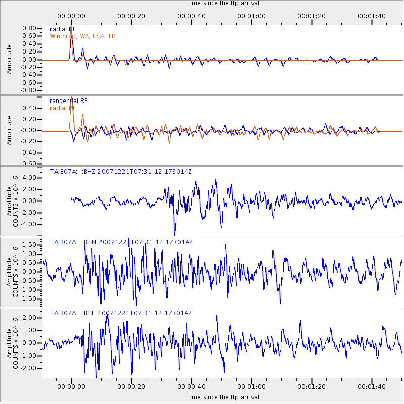
Signal To Noise
| Channel | StoN | STA | LTA |
| TA:B07A: :BHN:20071221T07:31:12.173014Z | 2.139641 | 5.676601E-7 | 2.6530623E-7 |
| TA:B07A: :BHE:20071221T07:31:12.173014Z | 2.3474958 | 6.7587047E-7 | 2.8791126E-7 |
| TA:B07A: :BHZ:20071221T07:31:12.173014Z | 4.27266 | 1.9986774E-6 | 4.6778294E-7 |
| Arrivals |
| Ps | 3.9 SECOND |
| PpPs | 12 SECOND |
| PsPs/PpSs | 16 SECOND |


