
Station TA B07A - Winthrop, WA, USA
Network: TA - USArray Transportable Network (new EarthScope stations)
Nearby stations (2 deg radius)
| Station | Name | (Lat, Lon) | Start / End | Elevation |
| B07A | Winthrop, WA, USA | (48.46, -120.12) | 2006-09-15 / 2499-01-01 | 0.8 km |
| Crust2 Type: | L8,thin continental arc, Cordilleras, 0.5 km seds. |
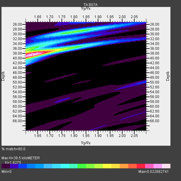
| Thickness Estimate: | 38 km |
| Thickness StdDev: | 1.1 km |
| Vp/Vs Estimate: | 1.63 |
| Vp/Vs StdDev: | 0.02 |
| Vs Estimate: | 4.035 km/s |
| Poisson's Ratio: | 0.20 |
| Peak Value: | 0.02 |
| Assumed Vp: | 6.566 km/s |
| Ps Weight: | 0.33333334 |
| PpPs Weight: | 0.33333334 |
| PsPs Weight: | 0.33333328 |
| Residual Complexity: | 0.577 |
| Nearby stations H: | +- |
| (2.0 deg) Vp/Vs: | +- |
17 with match > 90% ( 27.868853 %) and 44 with match > 80% ( 72.13115 %) out of 61.
Download stack as xyz text file.
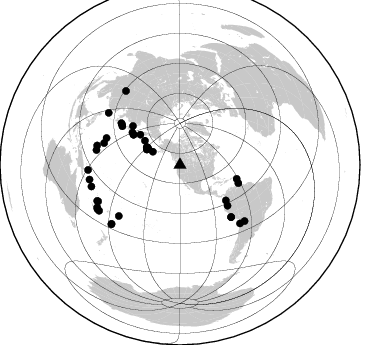
Azimuth Distribution of Events:
Prior Results for this Station
| Study | Thickness | Vp/Vs | Vp | Vs | Poissons Ratio | Extra |
| EARS | 38 km | 1.63 | 6.566 km/s | 4.035 km/s | 0.20 | |
| Crust2.0 | 34 km | 1.77 | 6.566 km/s | 3.707 km/s | 0.27 | L8,thin continental arc, Cordilleras, 0.5 km seds. |
| Global Maxima | 38 km | 1.63 | 6.566 km/s | 4.035 km/s | 0.20 | amp=0.022882741 |
| Local Maxima 1 | 29 km | 1.80 | 6.566 km/s | 3.653 km/s | 0.28 | amp=0.011616076 |
| Local Maxima 2 | 38 km | 1.61 | 6.566 km/s | 4.091 km/s | 0.18 | amp=0.010342448 |
| Local Maxima 3 | 36 km | 1.60 | 6.566 km/s | 4.104 km/s | 0.18 | amp=0.008042445 |
| Local Maxima 4 | 35 km | 1.81 | 6.566 km/s | 3.623 km/s | 0.28 | amp=0.0047634523 |
| Predicted Arrivals for vertical incidence (zero ray parameter) | |
| Ps | 3.68 SECOND |
| PpPs | 15.41 SECOND |
| PsPs/PpSs | 19.09 SECOND |
Events Processed for this Station
Download zip of receiver functions as SAC
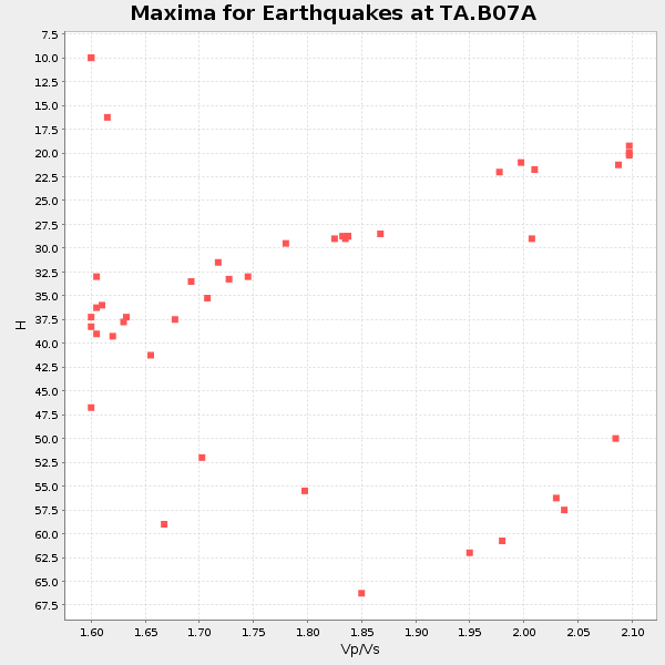
Plot maxima for each earthquake.
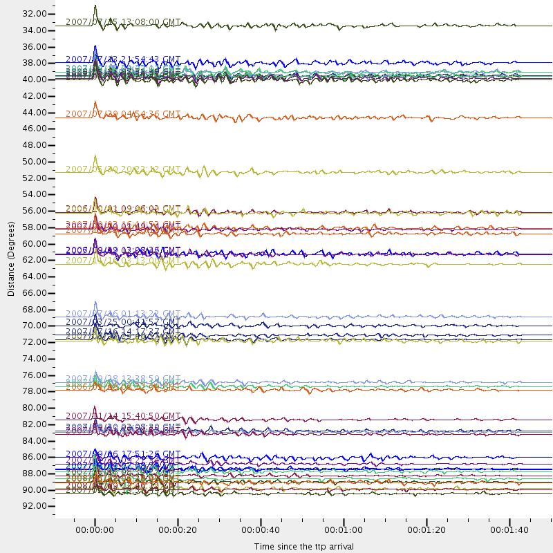
Events Used in the Stack
(44 events)| Radial Match | Distance | Baz | FERegion | Time | Lat/Lon | Depth | Magnitude |
| 96.52293 | 72.7 deg | 135.412 deg | Near Coast Of Peru | 2007/08/15 23:40:57 GMT | (-13.4, -76.6) | 39 km | 6.7 MB, 7.9 MS, 8.0 MW, 7.5 ME |
| 95.62911 | 90.2 deg | 246.567 deg | Vanuatu Islands | 2007/08/01 17:08:51 GMT | (-15.6, 167.7) | 120 km | 6.2 MB, 7.2 MW, 7.2 MW |
| 94.39385 | 83.5 deg | 134.216 deg | Northern Chile | 2007/11/14 15:40:50 GMT | (-22.2, -69.9) | 40 km | 6.7 MB, 7.4 MS, 7.7 MW, 7.4 ME |
| 94.32413 | 91.9 deg | 323.79 deg | Sichuan, China | 2008/05/12 06:28:01 GMT | (31.0, 103.3) | 19 km | 6.9 MB, 8.1 MS, 7.9 MW, 7.9 MW |
| 94.29478 | 36.6 deg | 295.127 deg | Andreanof Islands, Aleutian Is. | 2007/08/15 20:22:11 GMT | (50.3, -177.5) | 9.0 km | 6.3 MB, 6.2 MS, 6.4 MW, 5.9 ML |
| 93.9788 | 92.9 deg | 242.858 deg | Loyalty Islands | 2008/04/09 12:46:12 GMT | (-20.1, 168.9) | 33 km | 6.3 MB, 7.3 MS, 7.3 MW, 7.3 MW |
| 93.62731 | 90.1 deg | 229.301 deg | South Of Fiji Islands | 2007/12/09 07:28:20 GMT | (-26.0, -177.5) | 152 km | 7.0 MB, 7.8 MW, 7.7 MW |
| 93.322136 | 50.2 deg | 307.254 deg | Kamchatka Peninsula, Russia | 2007/05/30 20:22:12 GMT | (52.1, 157.3) | 116 km | 6.4 MB, 6.4 MW, 6.4 MW |
| 92.94462 | 57.9 deg | 127.707 deg | Near West Coast Of Colombia | 2007/09/10 01:49:14 GMT | (3.0, -78.0) | 31 km | 6.1 MB, 6.7 MS, 6.8 MW |
| 92.82729 | 91.0 deg | 256.384 deg | Solomon Islands | 2007/08/16 08:39:27 GMT | (-9.8, 159.5) | 10 km | 6.1 MB, 6.7 MS, 6.4 MW |
| 92.81908 | 78.4 deg | 290.001 deg | Volcano Islands, Japan Region | 2007/09/28 13:38:59 GMT | (22.0, 142.7) | 276 km | 6.7 MB, 7.4 MW, 7.4 MW |
| 92.566826 | 69.6 deg | 303.791 deg | Near West Coast Of Honshu, Japan | 2007/07/16 01:13:22 GMT | (37.5, 138.4) | 12 km | 6.5 MB, 6.4 MS, 6.6 MW, 6.5 MW |
| 92.26743 | 89.5 deg | 246.015 deg | Vanuatu Islands | 2007/07/15 09:27:34 GMT | (-15.4, 168.6) | 8.0 km | 6.0 MB, 5.8 MS, 6.1 MW, 6.0 MW |
| 92.11732 | 85.0 deg | 280.017 deg | South Of Mariana Islands | 2007/09/30 02:08:30 GMT | (10.5, 145.7) | 14 km | 6.4 MB, 7.1 MS, 6.9 MW, 6.9 MW |
| 91.77014 | 30.3 deg | 295.931 deg | Fox Islands, Aleutian Islands | 2007/07/15 13:08:00 GMT | (52.5, -168.0) | 10 km | 5.8 MB, 5.9 MS, 6.1 MW, 6.0 MW |
| 91.52006 | 37.5 deg | 297.458 deg | Andreanof Islands, Aleutian Is. | 2007/12/19 09:30:27 GMT | (51.4, -179.5) | 29 km | 6.4 MB, 7.1 MS, 7.1 MW, 7.0 MW |
| 90.92656 | 61.2 deg | 309.523 deg | Sakhalin, Russia | 2007/08/02 02:37:42 GMT | (47.1, 141.8) | 5.0 km | 6.2 MS, 5.3 MB, 6.2 MW, 6.2 MW |
| 89.7964 | 91.5 deg | 260.808 deg | Solomon Islands | 2007/04/01 21:11:33 GMT | (-7.3, 155.7) | 10 km | 6.3 MB |
| 89.61622 | 37.1 deg | 298.141 deg | Andreanof Islands, Aleutian Is. | 2008/04/16 05:54:19 GMT | (51.9, -179.2) | 13 km | 6.1 MB, 6.5 MS, 6.6 MW, 6.6 MW |
| 88.70006 | 79.0 deg | 285.96 deg | Mariana Islands | 2007/10/31 03:30:17 GMT | (18.9, 145.4) | 223 km | 6.2 MB, 7.2 MW, 7.2 MW |
| 88.386765 | 79.5 deg | 230.132 deg | Samoa Islands Region | 2006/09/28 06:22:09 GMT | (-16.6, -172.0) | 28 km | 6.5 MB, 6.6 MS, 6.9 MW, 6.7 MW |
| 88.37715 | 58.4 deg | 103.731 deg | Windward Islands | 2007/11/29 19:00:19 GMT | (15.0, -61.3) | 148 km | 6.9 MB, 7.4 MW, 7.4 MW |
| 87.95958 | 72.1 deg | 305.477 deg | Sea Of Japan | 2007/07/16 14:17:37 GMT | (36.8, 134.9) | 350 km | 6.2 MB, 6.8 MW, 6.8 MW |
| 87.75076 | 57.7 deg | 304.154 deg | Kuril Islands | 2007/09/03 16:14:53 GMT | (45.8, 150.1) | 94 km | 6.3 MB, 6.2 MW, 6.2 ME |
| 87.10093 | 35.4 deg | 297.139 deg | Andreanof Islands, Aleutian Is. | 2007/07/13 21:54:43 GMT | (51.8, -176.3) | 35 km | 5.7 MB, 5.6 MS, 6.0 MW, 5.9 MW |
| 87.098625 | 37.2 deg | 298.168 deg | Andreanof Islands, Aleutian Is. | 2008/04/15 22:59:51 GMT | (51.9, -179.4) | 10 km | 6.1 MB, 6.4 MS, 6.4 MW, 6.4 MW |
| 86.92809 | 85.1 deg | 283.248 deg | South Of Mariana Islands | 2008/05/09 21:51:29 GMT | (12.5, 143.2) | 76 km | 6.1 MB, 6.7 MW, 6.7 MW |
| 86.107834 | 90.5 deg | 229.3 deg | South Of Fiji Islands | 2007/07/18 00:07:35 GMT | (-26.3, -177.7) | 10 km | 5.8 MB, 5.9 MS, 6.1 MW, 6.0 MW |
| 85.06568 | 85.4 deg | 130.915 deg | Jujuy Province, Argentina | 2007/07/21 15:34:52 GMT | (-22.2, -65.8) | 290 km | 5.8 MB, 6.4 MW, 6.3 MW |
| 84.11875 | 55.5 deg | 303.16 deg | Kuril Islands | 2006/10/01 09:06:02 GMT | (46.5, 153.2) | 19 km | 6.1 MB, 6.4 MS, 6.6 MW, 6.5 MW |
| 84.0858 | 37.7 deg | 297.527 deg | Andreanof Islands, Aleutian Is. | 2007/08/02 03:21:42 GMT | (51.3, -180.0) | 21 km | 6.3 MB, 6.6 MS, 6.7 MW, 6.6 MW |
| 83.51767 | 37.1 deg | 297.263 deg | Andreanof Islands, Aleutian Is. | 2007/12/21 07:24:34 GMT | (51.4, -179.0) | 30 km | 6.1 MB, 6.2 MW, 6.3 ML |
| 83.49494 | 93.5 deg | 241.926 deg | Southeast Of Loyalty Islands | 2007/09/27 19:57:44 GMT | (-21.1, 169.3) | 9.0 km | 6.2 MB, 6.3 MS, 6.1 MW, 6.1 MW |
| 83.229065 | 61.1 deg | 107.253 deg | Trinidad | 2006/09/29 13:08:26 GMT | (10.9, -61.8) | 53 km | 5.9 MB, 5.4 MS, 6.1 MW, 6.0 MW |
| 83.19454 | 88.6 deg | 306.086 deg | Taiwan Region | 2007/09/06 17:51:26 GMT | (24.3, 122.2) | 53 km | 6.1 MB, 6.2 MW, 6.1 ME |
| 83.174675 | 72.9 deg | 135.518 deg | Near Coast Of Peru | 2007/08/17 13:18:13 GMT | (-13.6, -76.6) | 48 km | 5.6 MB, 5.6 MS, 5.9 MW |
| 82.95331 | 37.2 deg | 297.095 deg | Andreanof Islands, Aleutian Is. | 2007/12/21 07:23:35 GMT | (51.2, -179.0) | 30 km | 5.7 MB, 5.5 ML |
| 82.94269 | 36.7 deg | 295.01 deg | Andreanof Islands, Aleutian Is. | 2007/08/16 04:03:03 GMT | (50.2, -177.6) | 15 km | 5.8 MB |
| 82.76701 | 42.8 deg | 304.438 deg | Komandorskiye Ostrova Region | 2007/07/29 04:54:36 GMT | (53.6, 169.7) | 26 km | 6.0 MB, 5.5 MS, 5.9 MW, 5.8 MW |
| 82.22851 | 92.8 deg | 240.497 deg | Southeast Of Loyalty Islands | 2007/07/27 14:46:26 GMT | (-21.5, 170.9) | 10 km | 6.0 MB, 6.0 MS, 6.1 MW, 6.1 MW |
| 81.03192 | 70.8 deg | 304.781 deg | Near West Coast Of Honshu, Japan | 2007/03/25 00:41:57 GMT | (37.3, 136.6) | 8.0 km | 6.1 MB, 6.8 MS, 6.7 MW, 6.6 MW |
| 80.68529 | 55.6 deg | 302.928 deg | Kuril Islands | 2006/10/13 13:47:39 GMT | (46.3, 153.3) | 8.0 km | 5.5 MB, 5.8 MS, 6.3 MW, 5.8 MW |
| 80.48533 | 62.5 deg | 130.707 deg | Peru-Ecuador Border Region | 2007/11/16 03:13:00 GMT | (-2.3, -77.8) | 123 km | 6.3 MB, 6.8 MW, 6.7 MW |
| 80.00873 | 91.9 deg | 266.841 deg | New Ireland Region, P.N.G. | 2007/06/18 06:18:48 GMT | (-3.6, 151.0) | 26 km | 5.7 MB, 6.2 MS, 6.3 MW, 6.1 MW |
Losers
(17 events)| Radial Match | Distance | Baz | FERegion | Time | Lat/Lon | Depth | Magnitude | Reason |
| 77.74199 | 36.7 deg | 298.466 deg | Andreanof Islands, Aleutian Is. | 2008/03/22 21:24:11 GMT | (52.2, -178.7) | 132 km | 5.8 MB, 6.2 MW, 6.1 MW | |
| 75.69306 | 95.4 deg | 296.943 deg | Philippine Islands Region | 2008/03/03 14:11:14 GMT | (13.4, 125.6) | 24 km | 6.4 MB, 6.9 MW, 6.8 MW | |
| 75.62898 | 93.0 deg | 242.815 deg | Loyalty Islands | 2008/04/09 11:13:17 GMT | (-20.2, 168.9) | 13 km | 5.6 MB, 6.3 MS, 6.4 MW, 6.3 MW | |
| 69.02619 | 68.9 deg | 300.88 deg | Near East Coast Of Honshu, Japan | 2008/05/07 16:02:02 GMT | (36.2, 141.5) | 19 km | 5.7 MB, 6.2 MW, 6.2 MW | |
| 67.35515 | 92.8 deg | 242.895 deg | Vanuatu Islands | 2008/04/28 18:33:34 GMT | (-19.9, 169.0) | 32 km | 6.2 MB, 6.2 MS, 6.4 MW, 6.4 MW | |
| 63.192646 | 83.8 deg | 235.345 deg | Fiji Islands Region | 2008/04/18 20:39:07 GMT | (-17.3, -179.0) | 554 km | 5.9 MB, 6.3 MW, 6.3 MW | |
| 62.68052 | 93.1 deg | 242.66 deg | Loyalty Islands | 2008/04/10 01:10:02 GMT | (-20.3, 168.9) | 35 km | 5.5 MB, 5.5 MS, 5.8 MW | |
| 62.134346 | 42.5 deg | 134.834 deg | Near Coast Of Guatemala | 2008/04/15 03:03:04 GMT | (13.6, -90.6) | 33 km | 5.6 MB, 5.8 MS, 6.1 MW, 6.1 MW | |
| 58.81172 | 93.1 deg | 242.801 deg | Loyalty Islands | 2008/04/19 05:58:42 GMT | (-20.3, 168.8) | 14 km | 5.7 MB, 6.2 MS, 6.3 MW, 6.2 MW | |
| 56.80908 | 93.2 deg | 242.703 deg | Loyalty Islands | 2008/04/11 17:45:05 GMT | (-20.4, 168.8) | 35 km | 5.7 MB, 5.9 MS, 6.0 MW, 6.0 MW | |
| 56.745544 | 93.1 deg | 242.803 deg | Loyalty Islands | 2008/04/28 20:26:53 GMT | (-20.2, 168.8) | 35 km | 5.8 MB, 5.7 MS, 6.1 MW, 6.0 MW | |
| 50.604046 | 93.0 deg | 242.777 deg | Loyalty Islands | 2008/04/09 11:23:40 GMT | (-20.2, 168.9) | 35 km | 5.7 MB, 6.3 MW, 6.3 MW | |
| 49.76769 | 82.1 deg | 132.323 deg | Chile-Bolivia Border Region | 2008/03/24 20:39:07 GMT | (-20.0, -69.0) | 120 km | 5.7 MB, 6.2 MW, 6.1 MW | |
| 48.80028 | 95.3 deg | 85.81 deg | Central Mid-Atlantic Ridge | 2008/04/24 12:14:49 GMT | (-1.2, -23.5) | 10 km | 6.0 MS, 5.4 MB, 6.5 MW, 6.4 MW | |
| 45.098892 | 91.2 deg | 246.372 deg | Vanuatu Islands | 2008/03/12 11:36:55 GMT | (-16.5, 167.2) | 10 km | 5.6 MB, 6.3 MW | |
| 44.386265 | 92.5 deg | 243.245 deg | Vanuatu Islands | 2008/05/01 04:57:50 GMT | (-19.5, 168.9) | 35 km | 5.7 MB, 5.2 MS, 5.7 MW, 5.7 MW | |
| 32.613888 | 60.3 deg | 303.717 deg | Kuril Islands | 2008/04/12 00:46:28 GMT | (43.9, 147.5) | 64 km | 5.7 MB |
