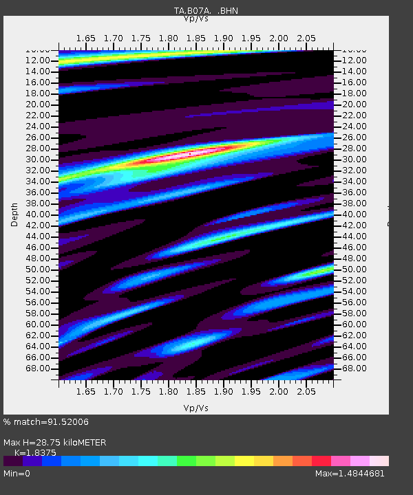
B07A Winthrop, WA, USA - Earthquake Result Viewer
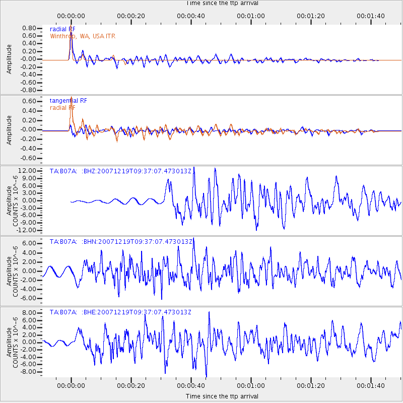
Earthquake location: Andreanof Islands, Aleutian Is.
Earthquake latitude/longitude: 51.4/-179.5
Earthquake time(UTC): 2007/12/19 (353) 09:30:27 GMT
Earthquake Depth: 29 km
Earthquake Magnitude: 6.4 MB, 7.1 MS, 7.1 MW, 7.0 MW
Earthquake Catalog/Contributor: WHDF/NEIC
Network: TA USArray Transportable Network (new EarthScope stations)
Station: B07A Winthrop, WA, USA
Lat/Lon: 48.46 N/120.12 W
Elevation: 781 m
Distance: 37.5 deg
Az: 70.408 deg
Baz: 297.458 deg
Ray Param: 0.07607532
Estimated Moho Depth: 28.75 km
Estimated Crust Vp/Vs: 1.84
Assumed Crust Vp: 6.566 km/s
Estimated Crust Vs: 3.573 km/s
Estimated Crust Poisson's Ratio: 0.29
Radial Match: 91.52006 %
Radial Bump: 400
Transverse Match: 72.70538 %
Transverse Bump: 400
SOD ConfigId: 2564
Insert Time: 2010-03-07 02:55:15.619 +0000
GWidth: 2.5
Max Bumps: 400
Tol: 0.001

Signal To Noise

ChannelStoNSTALTA
TA:B07A: :BHN:20071219T09:37:07.473013Z3.44615841.828337E-65.305435E-7
TA:B07A: :BHE:20071219T09:37:07.473013Z5.78338152.0582324E-63.5588735E-7
TA:B07A: :BHZ:20071219T09:37:07.473013Z6.51686244.3329087E-66.648765E-7
Arrivals
Ps3.9 SECOND
PpPs12 SECOND
PsPs/PpSs15 SECOND