You are here: Home > Network List > TA - USArray Transportable Network (new EarthScope stations) Stations List
> Station B07A Winthrop, WA, USA > Earthquake Result Viewer
B07A Winthrop, WA, USA - Earthquake Result Viewer
| Earthquake location: |
Volcano Islands, Japan Region |
| Earthquake latitude/longitude: |
22.0/142.7 |
| Earthquake time(UTC): |
2007/09/28 (271) 13:38:59 GMT |
| Earthquake Depth: |
276 km |
| Earthquake Magnitude: |
6.7 MB, 7.4 MW, 7.4 MW |
| Earthquake Catalog/Contributor: |
WHDF/NEIC |
|
| Network: |
TA USArray Transportable Network (new EarthScope stations) |
| Station: |
B07A Winthrop, WA, USA |
| Lat/Lon: |
48.46 N/120.12 W |
| Elevation: |
781 m |
|
| Distance: |
78.4 deg |
| Az: |
42.376 deg |
| Baz: |
290.001 deg |
| Ray Param: |
0.04890274 |
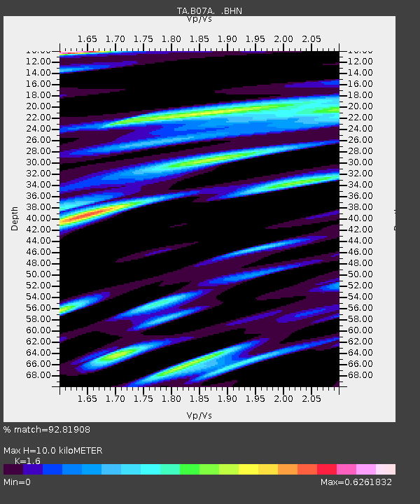
| Estimated Moho Depth: |
10.0 km |
| Estimated Crust Vp/Vs: |
1.60 |
| Assumed Crust Vp: |
6.566 km/s |
| Estimated Crust Vs: |
4.104 km/s |
| Estimated Crust Poisson's Ratio: |
0.18 |
|
| Radial Match: |
92.81908 % |
| Radial Bump: |
400 |
| Transverse Match: |
82.78958 % |
| Transverse Bump: |
400 |
| SOD ConfigId: |
2564 |
| Insert Time: |
2010-03-07 02:55:25.790 +0000 |
| GWidth: |
2.5 |
| Max Bumps: |
400 |
| Tol: |
0.001 |
|
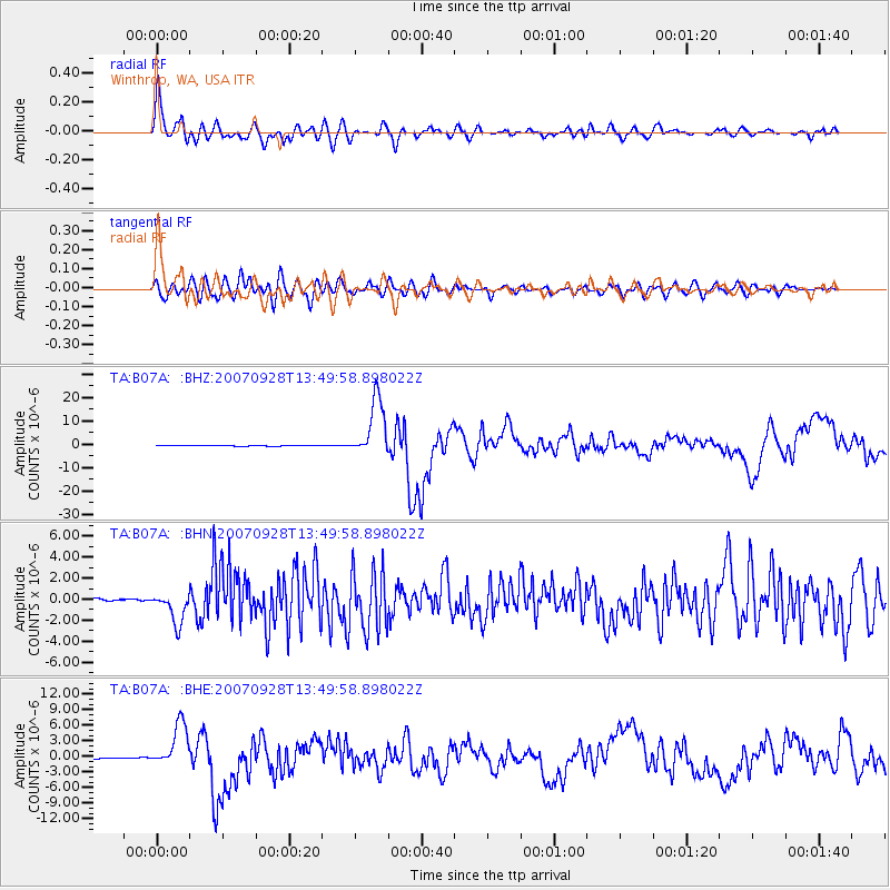
Signal To Noise
| Channel | StoN | STA | LTA |
| TA:B07A: :BHN:20070928T13:49:58.898022Z | 19.588797 | 1.48852E-6 | 7.598833E-8 |
| TA:B07A: :BHE:20070928T13:49:58.898022Z | 53.113914 | 4.249973E-6 | 8.0016186E-8 |
| TA:B07A: :BHZ:20070928T13:49:58.898022Z | 85.02634 | 1.2397195E-5 | 1.4580418E-7 |
| Arrivals |
| Ps | 0.9 SECOND |
| PpPs | 3.8 SECOND |
| PsPs/PpSs | 4.8 SECOND |


