You are here: Home > Network List > TA - USArray Transportable Network (new EarthScope stations) Stations List
> Station B07A Winthrop, WA, USA > Earthquake Result Viewer
B07A Winthrop, WA, USA - Earthquake Result Viewer
| Earthquake location: |
Andreanof Islands, Aleutian Is. |
| Earthquake latitude/longitude: |
50.2/-177.6 |
| Earthquake time(UTC): |
2007/08/16 (228) 04:03:03 GMT |
| Earthquake Depth: |
15 km |
| Earthquake Magnitude: |
5.8 MB |
| Earthquake Catalog/Contributor: |
WHDF/NEIC |
|
| Network: |
TA USArray Transportable Network (new EarthScope stations) |
| Station: |
B07A Winthrop, WA, USA |
| Lat/Lon: |
48.46 N/120.12 W |
| Elevation: |
781 m |
|
| Distance: |
36.7 deg |
| Az: |
69.965 deg |
| Baz: |
295.01 deg |
| Ray Param: |
0.076543234 |
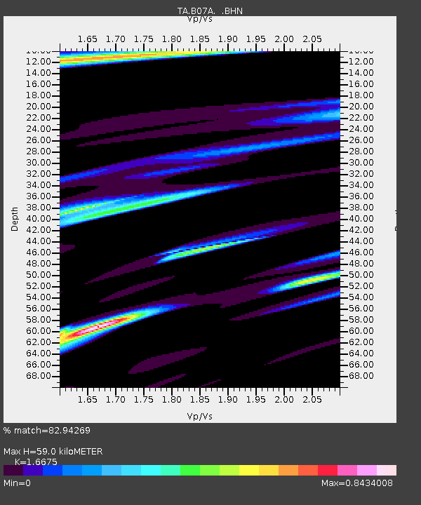
| Estimated Moho Depth: |
59.0 km |
| Estimated Crust Vp/Vs: |
1.67 |
| Assumed Crust Vp: |
6.566 km/s |
| Estimated Crust Vs: |
3.938 km/s |
| Estimated Crust Poisson's Ratio: |
0.22 |
|
| Radial Match: |
82.94269 % |
| Radial Bump: |
284 |
| Transverse Match: |
53.00505 % |
| Transverse Bump: |
362 |
| SOD ConfigId: |
2564 |
| Insert Time: |
2010-03-07 02:55:36.612 +0000 |
| GWidth: |
2.5 |
| Max Bumps: |
400 |
| Tol: |
0.001 |
|
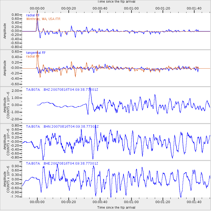
Signal To Noise
| Channel | StoN | STA | LTA |
| TA:B07A: :BHN:20070816T04:09:38.77301Z | 3.2265403 | 5.154139E-7 | 1.5974196E-7 |
| TA:B07A: :BHE:20070816T04:09:38.77301Z | 1.4876862 | 4.7494598E-7 | 3.1925146E-7 |
| TA:B07A: :BHZ:20070816T04:09:38.77301Z | 4.126797 | 1.0044979E-6 | 2.434086E-7 |
| Arrivals |
| Ps | 6.5 SECOND |
| PpPs | 22 SECOND |
| PsPs/PpSs | 29 SECOND |


