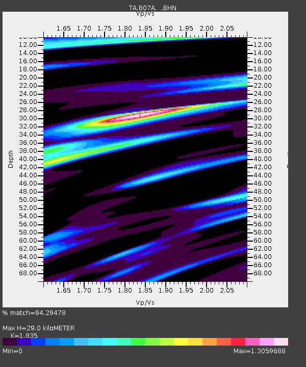
B07A Winthrop, WA, USA - Earthquake Result Viewer

Earthquake location: Andreanof Islands, Aleutian Is.
Earthquake latitude/longitude: 50.3/-177.5
Earthquake time(UTC): 2007/08/15 (227) 20:22:11 GMT
Earthquake Depth: 9.0 km
Earthquake Magnitude: 6.3 MB, 6.2 MS, 6.4 MW, 5.9 ML
Earthquake Catalog/Contributor: WHDF/NEIC
Network: TA USArray Transportable Network (new EarthScope stations)
Station: B07A Winthrop, WA, USA
Lat/Lon: 48.46 N/120.12 W
Elevation: 781 m
Distance: 36.6 deg
Az: 70.075 deg
Baz: 295.127 deg
Ray Param: 0.07657817
Estimated Moho Depth: 29.0 km
Estimated Crust Vp/Vs: 1.84
Assumed Crust Vp: 6.566 km/s
Estimated Crust Vs: 3.578 km/s
Estimated Crust Poisson's Ratio: 0.29
Radial Match: 94.29478 %
Radial Bump: 378
Transverse Match: 85.46025 %
Transverse Bump: 400
SOD ConfigId: 2564
Insert Time: 2010-03-07 02:55:39.502 +0000
GWidth: 2.5
Max Bumps: 400
Tol: 0.001

Signal To Noise

ChannelStoNSTALTA
TA:B07A: :BHN:20070815T20:28:46.923009Z18.5442396.675915E-73.5999943E-8
TA:B07A: :BHE:20070815T20:28:46.923009Z24.4489861.292199E-65.2852872E-8
TA:B07A: :BHZ:20070815T20:28:46.923009Z41.96522.4074388E-65.7367508E-8
Arrivals
Ps4.0 SECOND
PpPs12 SECOND
PsPs/PpSs16 SECOND