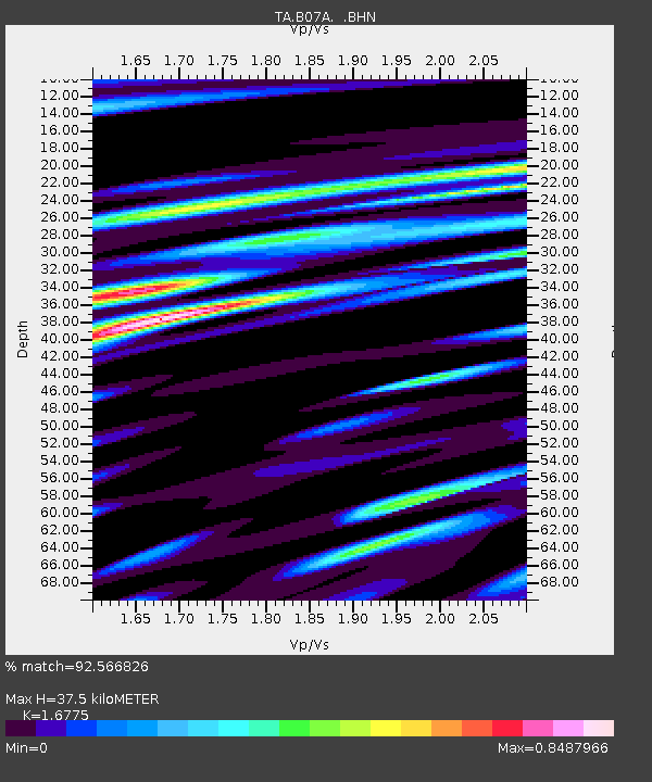
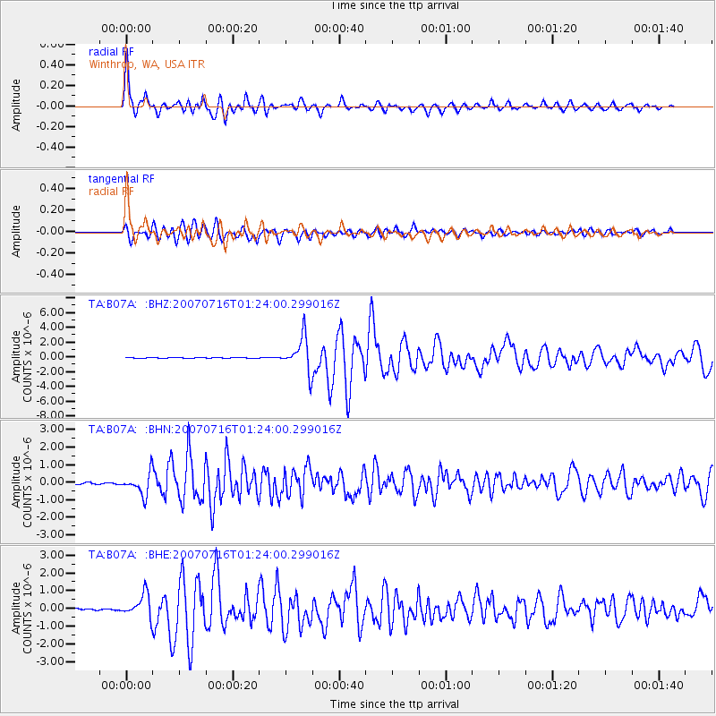
B07A Winthrop, WA, USA - Earthquake Result Viewer

Earthquake location: Near West Coast Of Honshu, Japan
Earthquake latitude/longitude: 37.5/138.4
Earthquake time(UTC): 2007/07/16 (197) 01:13:22 GMT
Earthquake Depth: 12 km
Earthquake Magnitude: 6.5 MB, 6.4 MS, 6.6 MW, 6.5 MW
Earthquake Catalog/Contributor: WHDF/NEIC
Network: TA USArray Transportable Network (new EarthScope stations)
Station: B07A Winthrop, WA, USA
Lat/Lon: 48.46 N/120.12 W
Elevation: 781 m
Distance: 69.6 deg
Az: 44.097 deg
Baz: 303.791 deg
Ray Param: 0.055506386
Estimated Moho Depth: 37.5 km
Estimated Crust Vp/Vs: 1.68
Assumed Crust Vp: 6.566 km/s
Estimated Crust Vs: 3.914 km/s
Estimated Crust Poisson's Ratio: 0.22
Radial Match: 92.566826 %
Radial Bump: 400
Transverse Match: 84.43722 %
Transverse Bump: 400
SOD ConfigId: 2564
Insert Time: 2010-03-07 02:55:55.436 +0000
GWidth: 2.5
Max Bumps: 400
Tol: 0.001

Signal To Noise

ChannelStoNSTALTA
TA:B07A: :BHN:20070716T01:24:00.299016Z9.9645366.3022213E-76.324651E-8
TA:B07A: :BHE:20070716T01:24:00.299016Z18.6489856.5896717E-73.5335283E-8
TA:B07A: :BHZ:20070716T01:24:00.299016Z45.312072.3502525E-65.186814E-8
Arrivals
Ps4.0 SECOND
PpPs15 SECOND
PsPs/PpSs19 SECOND