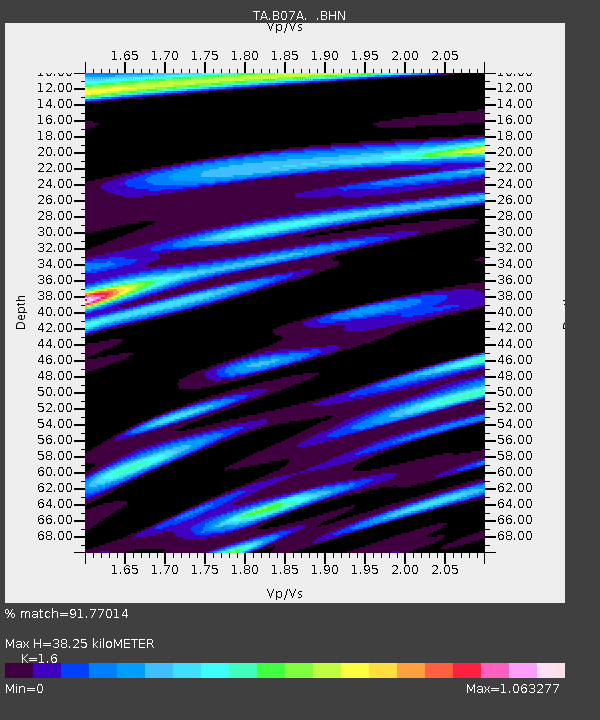
B07A Winthrop, WA, USA - Earthquake Result Viewer
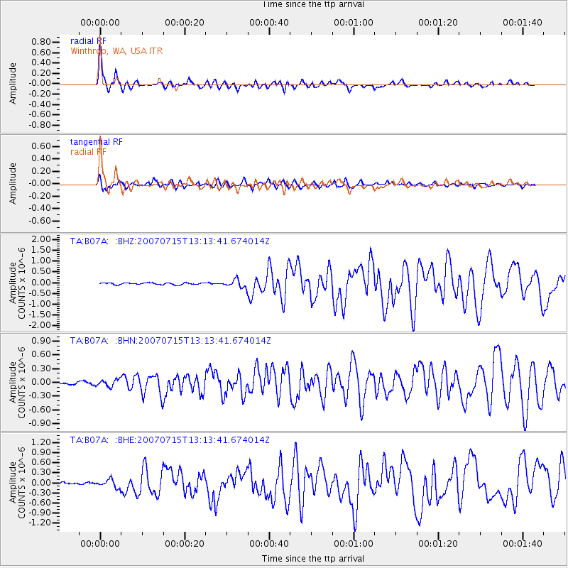
Earthquake location: Fox Islands, Aleutian Islands
Earthquake latitude/longitude: 52.5/-168.0
Earthquake time(UTC): 2007/07/15 (196) 13:08:00 GMT
Earthquake Depth: 10 km
Earthquake Magnitude: 5.8 MB, 5.9 MS, 6.1 MW, 6.0 MW
Earthquake Catalog/Contributor: WHDF/NEIC
Network: TA USArray Transportable Network (new EarthScope stations)
Station: B07A Winthrop, WA, USA
Lat/Lon: 48.46 N/120.12 W
Elevation: 781 m
Distance: 30.3 deg
Az: 78.16 deg
Baz: 295.931 deg
Ray Param: 0.079363026
Estimated Moho Depth: 38.25 km
Estimated Crust Vp/Vs: 1.60
Assumed Crust Vp: 6.566 km/s
Estimated Crust Vs: 4.104 km/s
Estimated Crust Poisson's Ratio: 0.18
Radial Match: 91.77014 %
Radial Bump: 400
Transverse Match: 84.583885 %
Transverse Bump: 400
SOD ConfigId: 2564
Insert Time: 2010-03-07 02:55:57.209 +0000
GWidth: 2.5
Max Bumps: 400
Tol: 0.001

Signal To Noise

ChannelStoNSTALTA
TA:B07A: :BHN:20070715T13:13:41.674014Z2.25735647.619449E-83.3753857E-8
TA:B07A: :BHE:20070715T13:13:41.674014Z3.32119081.2120401E-73.6494143E-8
TA:B07A: :BHZ:20070715T13:13:41.674014Z4.6436581.9066204E-74.1058584E-8
Arrivals
Ps3.8 SECOND
PpPs14 SECOND
PsPs/PpSs18 SECOND