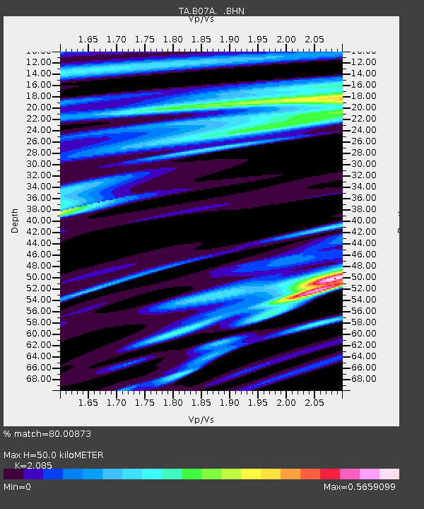
B07A Winthrop, WA, USA - Earthquake Result Viewer
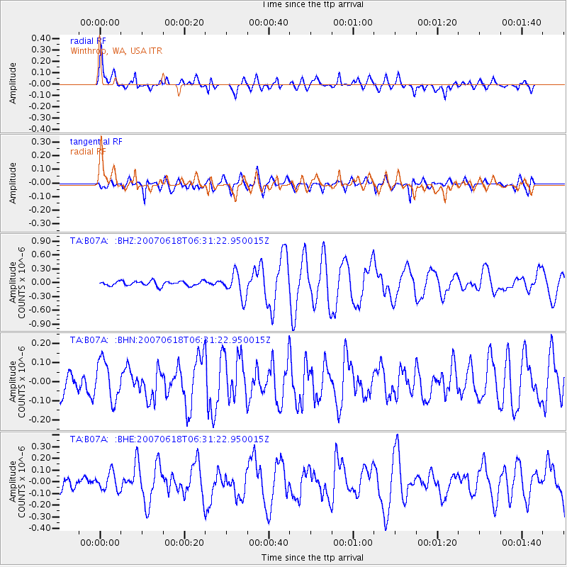
Earthquake location: New Ireland Region, P.N.G.
Earthquake latitude/longitude: -3.6/151.0
Earthquake time(UTC): 2007/06/18 (169) 06:18:48 GMT
Earthquake Depth: 26 km
Earthquake Magnitude: 5.7 MB, 6.2 MS, 6.3 MW, 6.1 MW
Earthquake Catalog/Contributor: WHDF/NEIC
Network: TA USArray Transportable Network (new EarthScope stations)
Station: B07A Winthrop, WA, USA
Lat/Lon: 48.46 N/120.12 W
Elevation: 781 m
Distance: 91.9 deg
Az: 41.75 deg
Baz: 266.841 deg
Ray Param: 0.041529644
Estimated Moho Depth: 50.0 km
Estimated Crust Vp/Vs: 2.09
Assumed Crust Vp: 6.566 km/s
Estimated Crust Vs: 3.149 km/s
Estimated Crust Poisson's Ratio: 0.35
Radial Match: 80.00873 %
Radial Bump: 400
Transverse Match: 66.97635 %
Transverse Bump: 400
SOD ConfigId: 2564
Insert Time: 2010-03-07 02:56:03.176 +0000
GWidth: 2.5
Max Bumps: 400
Tol: 0.001

Signal To Noise

ChannelStoNSTALTA
TA:B07A: :BHN:20070618T06:31:22.950015Z1.70326281.0592699E-76.219064E-8
TA:B07A: :BHE:20070618T06:31:22.950015Z1.19913167.762597E-86.4735154E-8
TA:B07A: :BHZ:20070618T06:31:22.950015Z5.4226772.7420353E-75.056608E-8
Arrivals
Ps8.4 SECOND
PpPs23 SECOND
PsPs/PpSs31 SECOND