You are here: Home > Network List > TA - USArray Transportable Network (new EarthScope stations) Stations List
> Station B07A Winthrop, WA, USA > Earthquake Result Viewer
B07A Winthrop, WA, USA - Earthquake Result Viewer
| Earthquake location: |
Kuril Islands |
| Earthquake latitude/longitude: |
46.3/153.3 |
| Earthquake time(UTC): |
2006/10/13 (286) 13:47:39 GMT |
| Earthquake Depth: |
8.0 km |
| Earthquake Magnitude: |
5.5 MB, 5.8 MS, 6.3 MW, 5.8 MW |
| Earthquake Catalog/Contributor: |
WHDF/NEIC |
|
| Network: |
TA USArray Transportable Network (new EarthScope stations) |
| Station: |
B07A Winthrop, WA, USA |
| Lat/Lon: |
48.46 N/120.12 W |
| Elevation: |
781 m |
|
| Distance: |
55.6 deg |
| Az: |
53.625 deg |
| Baz: |
302.928 deg |
| Ray Param: |
0.06468288 |
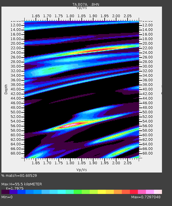
| Estimated Moho Depth: |
55.5 km |
| Estimated Crust Vp/Vs: |
1.80 |
| Assumed Crust Vp: |
6.566 km/s |
| Estimated Crust Vs: |
3.653 km/s |
| Estimated Crust Poisson's Ratio: |
0.28 |
|
| Radial Match: |
80.68529 % |
| Radial Bump: |
400 |
| Transverse Match: |
70.21633 % |
| Transverse Bump: |
400 |
| SOD ConfigId: |
2665 |
| Insert Time: |
2010-03-07 02:56:10.313 +0000 |
| GWidth: |
2.5 |
| Max Bumps: |
400 |
| Tol: |
0.001 |
|
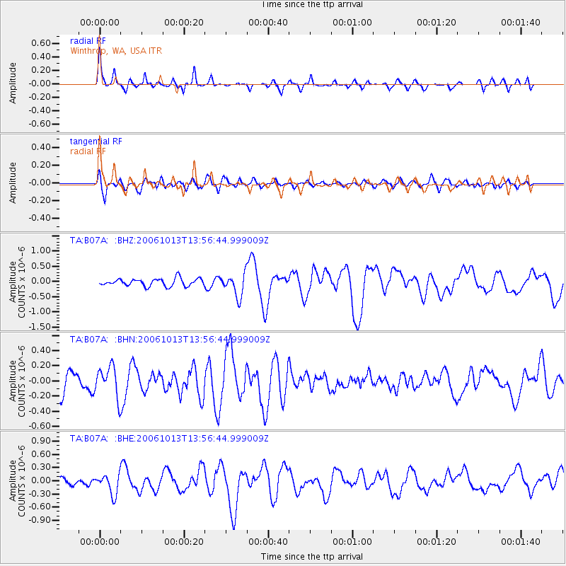
Signal To Noise
| Channel | StoN | STA | LTA |
| TA:B07A: :BHN:20061013T13:56:44.999009Z | 2.0857332 | 2.0351959E-7 | 9.757701E-8 |
| TA:B07A: :BHE:20061013T13:56:44.999009Z | 2.0517497 | 2.3288592E-7 | 1.13506005E-7 |
| TA:B07A: :BHZ:20061013T13:56:44.999009Z | 3.1700764 | 3.8512795E-7 | 1.2148854E-7 |
| Arrivals |
| Ps | 7.1 SECOND |
| PpPs | 22 SECOND |
| PsPs/PpSs | 30 SECOND |


