You are here: Home > Network List > TA - USArray Transportable Network (new EarthScope stations) Stations List
> Station B07A Winthrop, WA, USA > Earthquake Result Viewer
B07A Winthrop, WA, USA - Earthquake Result Viewer
*The percent match for this event was below the threshold and hence no stack was calculated.
| Earthquake location: |
Philippine Islands Region |
| Earthquake latitude/longitude: |
13.4/125.6 |
| Earthquake time(UTC): |
2008/03/03 (063) 14:11:14 GMT |
| Earthquake Depth: |
24 km |
| Earthquake Magnitude: |
6.4 MB, 6.9 MW, 6.8 MW |
| Earthquake Catalog/Contributor: |
WHDF/NEIC |
|
| Network: |
TA USArray Transportable Network (new EarthScope stations) |
| Station: |
B07A Winthrop, WA, USA |
| Lat/Lon: |
48.46 N/120.12 W |
| Elevation: |
781 m |
|
| Distance: |
95.4 deg |
| Az: |
37.564 deg |
| Baz: |
296.943 deg |
| Ray Param: |
$rayparam |
*The percent match for this event was below the threshold and hence was not used in the summary stack. |
|
| Radial Match: |
75.69306 % |
| Radial Bump: |
400 |
| Transverse Match: |
69.19398 % |
| Transverse Bump: |
400 |
| SOD ConfigId: |
2504 |
| Insert Time: |
2010-03-07 02:56:27.510 +0000 |
| GWidth: |
2.5 |
| Max Bumps: |
400 |
| Tol: |
0.001 |
|
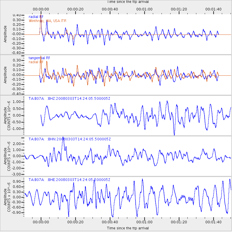
Signal To Noise
| Channel | StoN | STA | LTA |
| TA:B07A: :BHN:20080303T14:24:05.500005Z | 2.1777174 | 6.684156E-7 | 3.0693403E-7 |
| TA:B07A: :BHE:20080303T14:24:05.500005Z | 1.078253 | 2.677363E-7 | 2.4830564E-7 |
| TA:B07A: :BHZ:20080303T14:24:05.500005Z | 1.5715368 | 4.1938955E-7 | 2.6686587E-7 |
| Arrivals |
| Ps | |
| PpPs | |
| PsPs/PpSs | |


