You are here: Home > Network List > TA - USArray Transportable Network (new EarthScope stations) Stations List
> Station B07A Winthrop, WA, USA > Earthquake Result Viewer
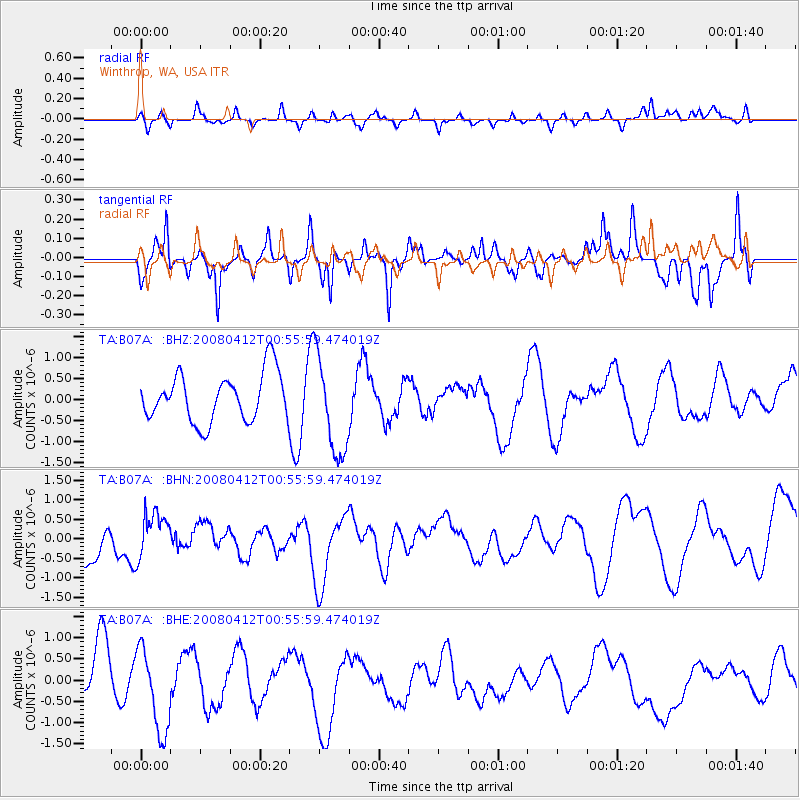
B07A Winthrop, WA, USA - Earthquake Result Viewer
*The percent match for this event was below the threshold and hence no stack was calculated.
| Earthquake location: |
Kuril Islands |
| Earthquake latitude/longitude: |
43.9/147.5 |
| Earthquake time(UTC): |
2008/04/12 (103) 00:46:28 GMT |
| Earthquake Depth: |
64 km |
| Earthquake Magnitude: |
5.7 MB |
| Earthquake Catalog/Contributor: |
WHDF/NEIC |
|
| Network: |
TA USArray Transportable Network (new EarthScope stations) |
| Station: |
B07A Winthrop, WA, USA |
| Lat/Lon: |
48.46 N/120.12 W |
| Elevation: |
781 m |
|
| Distance: |
60.3 deg |
| Az: |
49.965 deg |
| Baz: |
303.717 deg |
| Ray Param: |
$rayparam |
*The percent match for this event was below the threshold and hence was not used in the summary stack. |
|
| Radial Match: |
32.613888 % |
| Radial Bump: |
352 |
| Transverse Match: |
46.01716 % |
| Transverse Bump: |
275 |
| SOD ConfigId: |
2504 |
| Insert Time: |
2010-03-07 02:56:45.512 +0000 |
| GWidth: |
2.5 |
| Max Bumps: |
400 |
| Tol: |
0.001 |
|
Signal To Noise
| Channel | StoN | STA | LTA |
| TA:B07A: :BHN:20080412T00:55:59.474019Z | 0.9792857 | 5.8072044E-7 | 5.930041E-7 |
| TA:B07A: :BHE:20080412T00:55:59.474019Z | 1.5315204 | 9.990388E-7 | 6.5231836E-7 |
| TA:B07A: :BHZ:20080412T00:55:59.474019Z | 2.0335965 | 1.1702729E-6 | 5.754695E-7 |
| Arrivals |
| Ps | |
| PpPs | |
| PsPs/PpSs | |


