You are here: Home > Network List > TA - USArray Transportable Network (new EarthScope stations) Stations List
> Station G11A Walters Elk Ranch, Riggins, ID, USA > Earthquake Result Viewer
G11A Walters Elk Ranch, Riggins, ID, USA - Earthquake Result Viewer
| Earthquake location: |
Andreanof Islands, Aleutian Is. |
| Earthquake latitude/longitude: |
52.2/-178.7 |
| Earthquake time(UTC): |
2008/03/22 (082) 21:24:11 GMT |
| Earthquake Depth: |
132 km |
| Earthquake Magnitude: |
5.8 MB, 6.2 MW, 6.1 MW |
| Earthquake Catalog/Contributor: |
WHDF/NEIC |
|
| Network: |
TA USArray Transportable Network (new EarthScope stations) |
| Station: |
G11A Walters Elk Ranch, Riggins, ID, USA |
| Lat/Lon: |
45.40 N/116.27 W |
| Elevation: |
1343 m |
|
| Distance: |
40.6 deg |
| Az: |
73.904 deg |
| Baz: |
302.882 deg |
| Ray Param: |
0.0738564 |
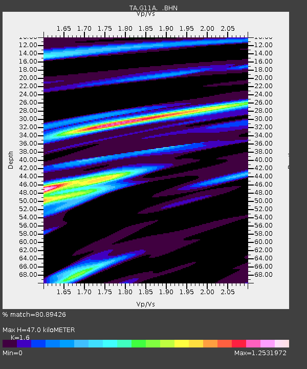
| Estimated Moho Depth: |
47.0 km |
| Estimated Crust Vp/Vs: |
1.60 |
| Assumed Crust Vp: |
6.571 km/s |
| Estimated Crust Vs: |
4.107 km/s |
| Estimated Crust Poisson's Ratio: |
0.18 |
|
| Radial Match: |
80.89426 % |
| Radial Bump: |
400 |
| Transverse Match: |
56.21179 % |
| Transverse Bump: |
400 |
| SOD ConfigId: |
2564 |
| Insert Time: |
2010-03-07 03:10:09.951 +0000 |
| GWidth: |
2.5 |
| Max Bumps: |
400 |
| Tol: |
0.001 |
|

Signal To Noise
| Channel | StoN | STA | LTA |
| TA:G11A: :BHN:20080322T21:31:07.22401Z | 6.482202 | 8.630234E-7 | 1.3313738E-7 |
| TA:G11A: :BHE:20080322T21:31:07.22401Z | 3.140728 | 6.7977174E-7 | 2.1643766E-7 |
| TA:G11A: :BHZ:20080322T21:31:07.22401Z | 7.6158395 | 1.7311532E-6 | 2.2730957E-7 |
| Arrivals |
| Ps | 4.7 SECOND |
| PpPs | 17 SECOND |
| PsPs/PpSs | 22 SECOND |


