
Station TA G11A - Walters Elk Ranch, Riggins, ID, USA
Network: TA - USArray Transportable Network (new EarthScope stations)
Nearby stations (2 deg radius)
| Station | Name | (Lat, Lon) | Start / End | Elevation |
| G11A | Walters Elk Ranch, Riggins, ID, USA | (45.40, -116.27) | 2006-11-08 / 2499-01-01 | 1.3 km |
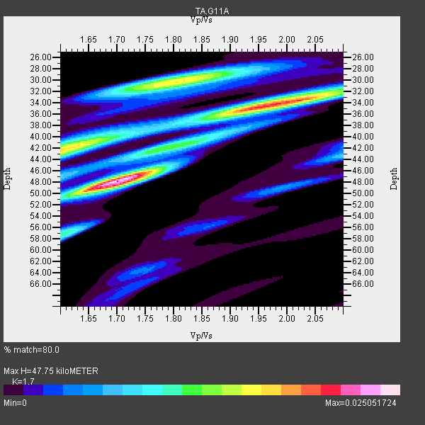
| Crust2 Type: | Q9,orogen/41km no ice, cordilleras, 0.25 km seds. |
| Thickness Estimate: | 48 km |
| Thickness StdDev: | 7.0 km |
| Vp/Vs Estimate: | 1.70 |
| Vp/Vs StdDev: | 0.14 |
| Vs Estimate: | 3.865 km/s |
| Poisson's Ratio: | 0.24 |
| Peak Value: | 0.03 |
| Assumed Vp: | 6.571 km/s |
| Ps Weight: | 0.33333334 |
| PpPs Weight: | 0.33333334 |
| PsPs Weight: | 0.33333328 |
| Residual Complexity: | 0.819 |
| Nearby stations H: | +- |
| (2.0 deg) Vp/Vs: | +- |
6 with match > 90% ( 28.571428 %) and 21 with match > 80% ( 100.0 %) out of 21.
Download stack as xyz text file.
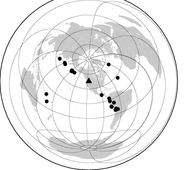
Azimuth Distribution of Events:
Prior Results for this Station
| Study | Thickness | Vp/Vs | Vp | Vs | Poissons Ratio | Extra |
| EARS | 48 km | 1.70 | 6.571 km/s | 3.865 km/s | 0.24 | |
| Crust2.0 | 41 km | 1.76 | 6.571 km/s | 3.735 km/s | 0.26 | Q9,orogen/41km no ice, cordilleras, 0.25 km seds. |
| Global Maxima | 48 km | 1.70 | 6.571 km/s | 3.865 km/s | 0.24 | amp=0.025051724 |
| Local Maxima 1 | 35 km | 1.95 | 6.571 km/s | 3.374 km/s | 0.32 | amp=0.019906303 |
| Local Maxima 2 | 30 km | 1.81 | 6.571 km/s | 3.64 km/s | 0.28 | amp=0.016334092 |
| Local Maxima 3 | 42 km | 1.60 | 6.571 km/s | 4.107 km/s | 0.18 | amp=0.016227681 |
| Local Maxima 4 | 32 km | 2.08 | 6.571 km/s | 3.163 km/s | 0.35 | amp=0.009068194 |
| Predicted Arrivals for vertical incidence (zero ray parameter) | |
| Ps | 5.09 SECOND |
| PpPs | 19.62 SECOND |
| PsPs/PpSs | 24.71 SECOND |
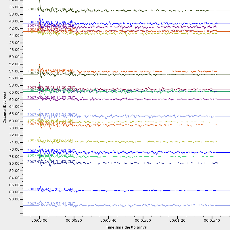
Events Processed for this Station
Download zip of receiver functions as SAC
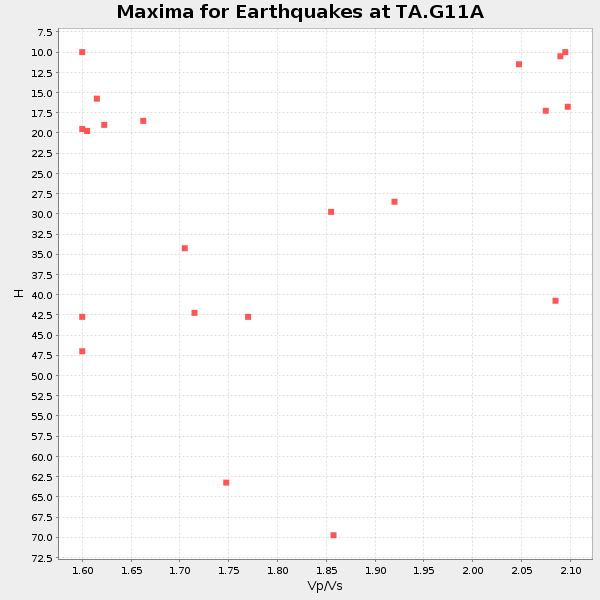
Plot maxima for each earthquake.
Events Used in the Stack
(21 events)| Radial Match | Distance | Baz | FERegion | Time | Lat/Lon | Depth | Magnitude |
| 97.61138 | 89.9 deg | 253.393 deg | Santa Cruz Islands | 2007/09/02 01:05:18 GMT | (-11.6, 165.8) | 35 km | 5.9 MB, 7.3 MS, 7.2 MW, 6.9 ME |
| 96.948395 | 79.4 deg | 136.984 deg | Northern Chile | 2007/11/14 15:40:50 GMT | (-22.2, -69.9) | 40 km | 6.7 MB, 7.4 MS, 7.7 MW, 7.4 ME |
| 96.04908 | 68.6 deg | 138.157 deg | Near Coast Of Peru | 2007/08/15 23:40:57 GMT | (-13.4, -76.6) | 39 km | 6.7 MB, 7.9 MS, 8.0 MW, 7.5 ME |
| 91.8829 | 40.4 deg | 299.817 deg | Andreanof Islands, Aleutian Is. | 2007/08/15 20:22:11 GMT | (50.3, -177.5) | 9.0 km | 6.3 MB, 6.2 MS, 6.4 MW, 5.9 ML |
| 91.5924 | 34.1 deg | 301.012 deg | Fox Islands, Aleutian Islands | 2007/07/15 13:08:00 GMT | (52.5, -168.0) | 10 km | 5.8 MB, 5.9 MS, 6.1 MW, 6.0 MW |
| 91.04893 | 81.4 deg | 133.665 deg | Jujuy Province, Argentina | 2007/07/21 15:34:52 GMT | (-22.2, -65.8) | 290 km | 5.8 MB, 6.4 MW, 6.3 MW |
| 89.91049 | 61.6 deg | 307.509 deg | Kuril Islands | 2007/09/03 16:14:53 GMT | (45.8, 150.1) | 94 km | 6.3 MB, 6.2 MW, 6.2 ME |
| 88.83406 | 74.7 deg | 307.867 deg | Near West Coast Of Honshu, Japan | 2007/03/25 00:41:57 GMT | (37.3, 136.6) | 8.0 km | 6.1 MB, 6.8 MS, 6.7 MW, 6.6 MW |
| 88.82323 | 53.9 deg | 130.021 deg | Near West Coast Of Colombia | 2007/09/10 01:49:14 GMT | (3.0, -78.0) | 31 km | 6.1 MB, 6.7 MS, 6.8 MW |
| 87.960434 | 59.1 deg | 305.71 deg | East Of Kuril Islands | 2007/10/25 13:50:02 GMT | (46.0, 154.2) | 10 km | 6.0 MB, 5.7 MS, 6.1 MW, 5.9 MW |
| 86.449135 | 58.5 deg | 133.224 deg | Peru-Ecuador Border Region | 2007/11/16 03:13:00 GMT | (-2.3, -77.8) | 123 km | 6.3 MB, 6.8 MW, 6.7 MW |
| 86.08843 | 41.3 deg | 301.913 deg | Andreanof Islands, Aleutian Is. | 2007/12/19 09:30:27 GMT | (51.4, -179.5) | 29 km | 6.4 MB, 7.1 MS, 7.1 MW, 7.0 MW |
| 85.74452 | 38.2 deg | 137.398 deg | Near Coast Of Guatemala | 2007/06/08 13:32:00 GMT | (13.8, -90.8) | 48 km | 5.5 MB, 5.4 MS, 5.8 MW, 5.8 MW |
| 84.88848 | 66.8 deg | 130.405 deg | Western Brazil | 2007/07/21 13:27:04 GMT | (-8.1, -71.3) | 645 km | 6.2 MB, 6.1 MW, 6.0 MW |
| 84.72516 | 53.0 deg | 49.885 deg | Northern Mid-Atlantic Ridge | 2007/05/23 04:41:46 GMT | (52.4, -31.8) | 10 km | 5.6 MS, 5.4 MB, 5.7 MW, 5.6 MW |
| 83.0904 | 59.2 deg | 83.245 deg | Northern Mid-Atlantic Ridge | 2007/08/09 17:25:05 GMT | (25.9, -45.0) | 10 km | 5.6 MW, 5.1 MS, 5.2 MB |
| 82.78137 | 69.6 deg | 138.185 deg | Near Coast Of Peru | 2007/08/16 05:16:56 GMT | (-14.3, -76.1) | 23 km | 5.8 MB, 6.1 MS, 6.3 MW, 6.2 ML |
| 81.54746 | 94.5 deg | 244.46 deg | Southeast Of Loyalty Islands | 2007/09/27 19:57:44 GMT | (-21.1, 169.3) | 9.0 km | 6.2 MB, 6.3 MS, 6.1 MW, 6.1 MW |
| 81.04208 | 39.2 deg | 301.743 deg | Andreanof Islands, Aleutian Is. | 2007/07/13 21:54:43 GMT | (51.8, -176.3) | 35 km | 5.7 MB, 5.6 MS, 6.0 MW, 5.9 MW |
| 80.89426 | 40.6 deg | 302.882 deg | Andreanof Islands, Aleutian Is. | 2008/03/22 21:24:11 GMT | (52.2, -178.7) | 132 km | 5.8 MB, 6.2 MW, 6.1 MW |
| 80.301285 | 78.0 deg | 135.061 deg | Chile-Bolivia Border Region | 2008/03/24 20:39:07 GMT | (-20.0, -69.0) | 120 km | 5.7 MB, 6.2 MW, 6.1 MW |
Losers
(0 events)| Radial Match | Distance | Baz | FERegion | Time | Lat/Lon | Depth | Magnitude | Reason |
