You are here: Home > Network List > TA - USArray Transportable Network (new EarthScope stations) Stations List
> Station G11A Walters Elk Ranch, Riggins, ID, USA > Earthquake Result Viewer
G11A Walters Elk Ranch, Riggins, ID, USA - Earthquake Result Viewer
| Earthquake location: |
Peru-Ecuador Border Region |
| Earthquake latitude/longitude: |
-2.3/-77.8 |
| Earthquake time(UTC): |
2007/11/16 (320) 03:13:00 GMT |
| Earthquake Depth: |
123 km |
| Earthquake Magnitude: |
6.3 MB, 6.8 MW, 6.7 MW |
| Earthquake Catalog/Contributor: |
WHDF/NEIC |
|
| Network: |
TA USArray Transportable Network (new EarthScope stations) |
| Station: |
G11A Walters Elk Ranch, Riggins, ID, USA |
| Lat/Lon: |
45.40 N/116.27 W |
| Elevation: |
1343 m |
|
| Distance: |
58.5 deg |
| Az: |
329.083 deg |
| Baz: |
133.224 deg |
| Ray Param: |
0.062456742 |
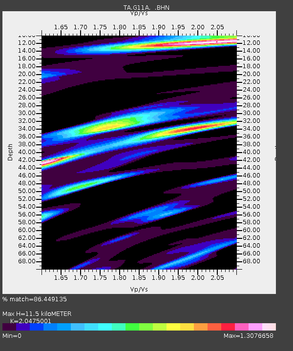
| Estimated Moho Depth: |
11.5 km |
| Estimated Crust Vp/Vs: |
2.05 |
| Assumed Crust Vp: |
6.571 km/s |
| Estimated Crust Vs: |
3.209 km/s |
| Estimated Crust Poisson's Ratio: |
0.34 |
|
| Radial Match: |
86.449135 % |
| Radial Bump: |
400 |
| Transverse Match: |
81.597534 % |
| Transverse Bump: |
400 |
| SOD ConfigId: |
2564 |
| Insert Time: |
2010-03-07 03:10:12.030 +0000 |
| GWidth: |
2.5 |
| Max Bumps: |
400 |
| Tol: |
0.001 |
|
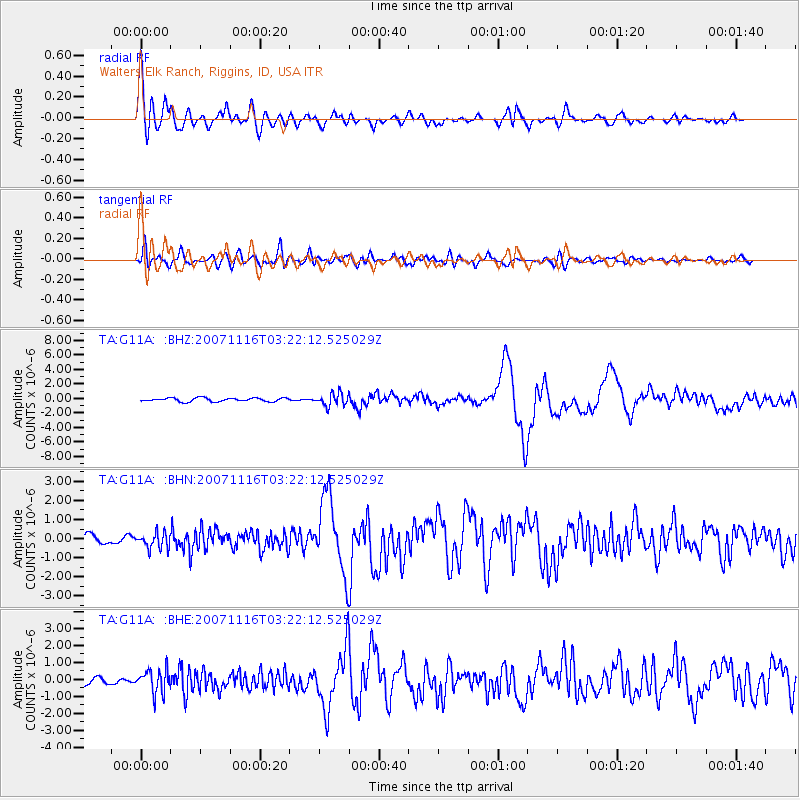
Signal To Noise
| Channel | StoN | STA | LTA |
| TA:G11A: :BHN:20071116T03:22:12.525029Z | 2.017178 | 4.0350133E-7 | 2.0003257E-7 |
| TA:G11A: :BHE:20071116T03:22:12.525029Z | 2.1164193 | 6.834255E-7 | 3.2291592E-7 |
| TA:G11A: :BHZ:20071116T03:22:12.525029Z | 3.5054066 | 8.6149674E-7 | 2.457623E-7 |
| Arrivals |
| Ps | 1.9 SECOND |
| PpPs | 5.1 SECOND |
| PsPs/PpSs | 7.0 SECOND |


