You are here: Home > Network List > TA - USArray Transportable Network (new EarthScope stations) Stations List
> Station G11A Walters Elk Ranch, Riggins, ID, USA > Earthquake Result Viewer
G11A Walters Elk Ranch, Riggins, ID, USA - Earthquake Result Viewer
| Earthquake location: |
Southeast Of Loyalty Islands |
| Earthquake latitude/longitude: |
-21.1/169.3 |
| Earthquake time(UTC): |
2007/09/27 (270) 19:57:44 GMT |
| Earthquake Depth: |
9.0 km |
| Earthquake Magnitude: |
6.2 MB, 6.3 MS, 6.1 MW, 6.1 MW |
| Earthquake Catalog/Contributor: |
WHDF/NEIC |
|
| Network: |
TA USArray Transportable Network (new EarthScope stations) |
| Station: |
G11A Walters Elk Ranch, Riggins, ID, USA |
| Lat/Lon: |
45.40 N/116.27 W |
| Elevation: |
1343 m |
|
| Distance: |
94.5 deg |
| Az: |
42.907 deg |
| Baz: |
244.46 deg |
| Ray Param: |
0.0410404 |
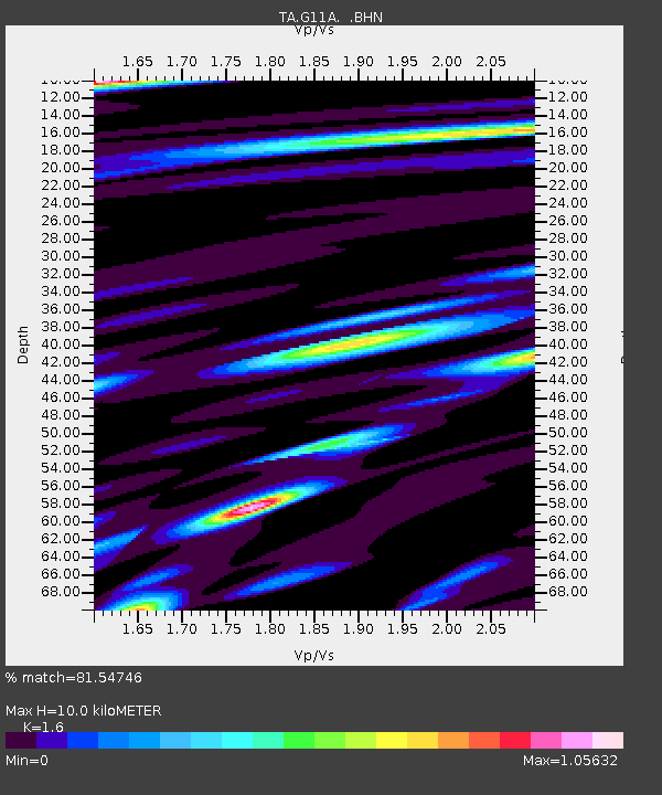
| Estimated Moho Depth: |
10.0 km |
| Estimated Crust Vp/Vs: |
1.60 |
| Assumed Crust Vp: |
6.571 km/s |
| Estimated Crust Vs: |
4.107 km/s |
| Estimated Crust Poisson's Ratio: |
0.18 |
|
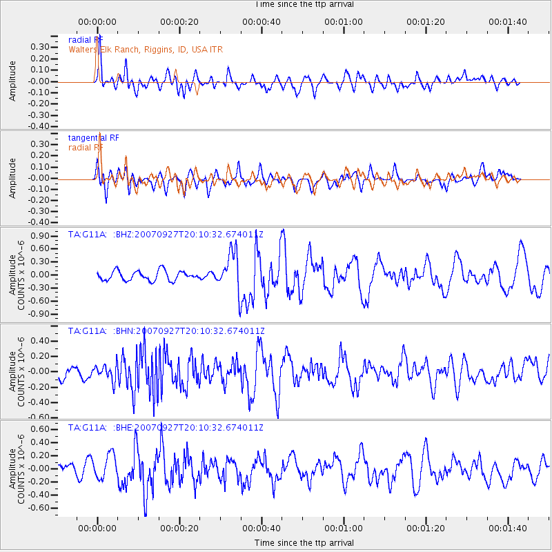
| Radial Match: |
81.54746 % |
| Radial Bump: |
400 |
| Transverse Match: |
74.13854 % |
| Transverse Bump: |
400 |
| SOD ConfigId: |
2564 |
| Insert Time: |
2010-03-07 03:10:15.396 +0000 |
| GWidth: |
2.5 |
| Max Bumps: |
400 |
| Tol: |
0.001 |
|
Signal To Noise
| Channel | StoN | STA | LTA |
| TA:G11A: :BHN:20070927T20:10:32.674011Z | 0.93202615 | 1.0173695E-7 | 1.0915676E-7 |
| TA:G11A: :BHE:20070927T20:10:32.674011Z | 3.0149584 | 1.8536373E-7 | 6.148136E-8 |
| TA:G11A: :BHZ:20070927T20:10:32.674011Z | 4.200925 | 4.6530002E-7 | 1.10761334E-7 |
| Arrivals |
| Ps | 0.9 SECOND |
| PpPs | 3.9 SECOND |
| PsPs/PpSs | 4.8 SECOND |


