You are here: Home > Network List > TA - USArray Transportable Network (new EarthScope stations) Stations List
> Station G11A Walters Elk Ranch, Riggins, ID, USA > Earthquake Result Viewer
G11A Walters Elk Ranch, Riggins, ID, USA - Earthquake Result Viewer
| Earthquake location: |
Near Coast Of Peru |
| Earthquake latitude/longitude: |
-14.3/-76.1 |
| Earthquake time(UTC): |
2007/08/16 (228) 05:16:56 GMT |
| Earthquake Depth: |
23 km |
| Earthquake Magnitude: |
5.8 MB, 6.1 MS, 6.3 MW, 6.2 ML |
| Earthquake Catalog/Contributor: |
WHDF/NEIC |
|
| Network: |
TA USArray Transportable Network (new EarthScope stations) |
| Station: |
G11A Walters Elk Ranch, Riggins, ID, USA |
| Lat/Lon: |
45.40 N/116.27 W |
| Elevation: |
1343 m |
|
| Distance: |
69.6 deg |
| Az: |
331.019 deg |
| Baz: |
138.185 deg |
| Ray Param: |
0.055495992 |
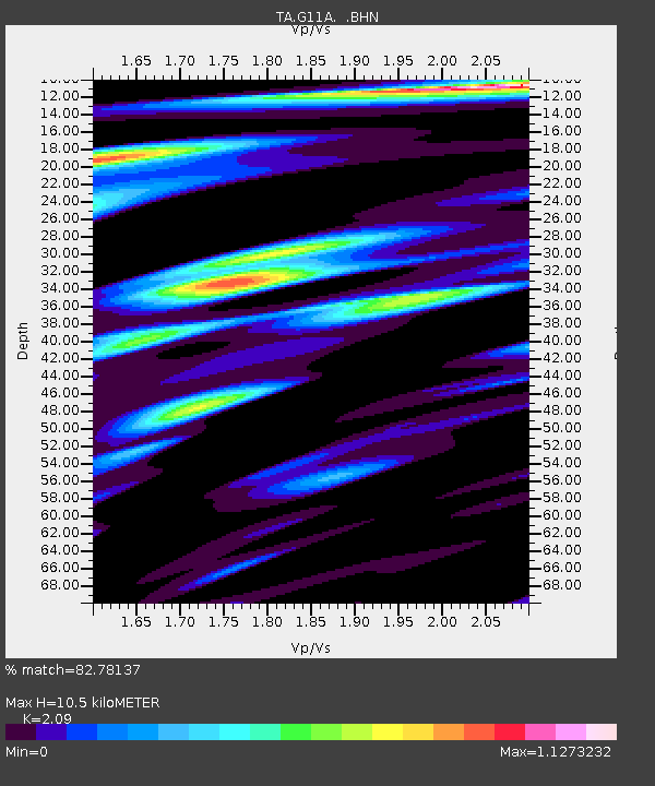
| Estimated Moho Depth: |
10.5 km |
| Estimated Crust Vp/Vs: |
2.09 |
| Assumed Crust Vp: |
6.571 km/s |
| Estimated Crust Vs: |
3.144 km/s |
| Estimated Crust Poisson's Ratio: |
0.35 |
|
| Radial Match: |
82.78137 % |
| Radial Bump: |
400 |
| Transverse Match: |
68.96316 % |
| Transverse Bump: |
400 |
| SOD ConfigId: |
2564 |
| Insert Time: |
2010-03-07 03:10:21.719 +0000 |
| GWidth: |
2.5 |
| Max Bumps: |
400 |
| Tol: |
0.001 |
|

Signal To Noise
| Channel | StoN | STA | LTA |
| TA:G11A: :BHN:20070816T05:27:32.300024Z | 1.4128131 | 1.512236E-7 | 1.0703724E-7 |
| TA:G11A: :BHE:20070816T05:27:32.300024Z | 1.371856 | 2.080607E-7 | 1.5166366E-7 |
| TA:G11A: :BHZ:20070816T05:27:32.300024Z | 3.0982096 | 3.9564082E-7 | 1.2769982E-7 |
| Arrivals |
| Ps | 1.8 SECOND |
| PpPs | 4.8 SECOND |
| PsPs/PpSs | 6.6 SECOND |


