You are here: Home > Network List > TA - USArray Transportable Network (new EarthScope stations) Stations List
> Station G11A Walters Elk Ranch, Riggins, ID, USA > Earthquake Result Viewer
G11A Walters Elk Ranch, Riggins, ID, USA - Earthquake Result Viewer
| Earthquake location: |
Andreanof Islands, Aleutian Is. |
| Earthquake latitude/longitude: |
50.3/-177.5 |
| Earthquake time(UTC): |
2007/08/15 (227) 20:22:11 GMT |
| Earthquake Depth: |
9.0 km |
| Earthquake Magnitude: |
6.3 MB, 6.2 MS, 6.4 MW, 5.9 ML |
| Earthquake Catalog/Contributor: |
WHDF/NEIC |
|
| Network: |
TA USArray Transportable Network (new EarthScope stations) |
| Station: |
G11A Walters Elk Ranch, Riggins, ID, USA |
| Lat/Lon: |
45.40 N/116.27 W |
| Elevation: |
1343 m |
|
| Distance: |
40.4 deg |
| Az: |
72.48 deg |
| Baz: |
299.817 deg |
| Ray Param: |
0.07443332 |
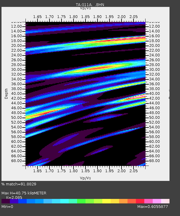
| Estimated Moho Depth: |
40.75 km |
| Estimated Crust Vp/Vs: |
2.09 |
| Assumed Crust Vp: |
6.571 km/s |
| Estimated Crust Vs: |
3.151 km/s |
| Estimated Crust Poisson's Ratio: |
0.35 |
|
| Radial Match: |
91.8829 % |
| Radial Bump: |
329 |
| Transverse Match: |
81.34431 % |
| Transverse Bump: |
400 |
| SOD ConfigId: |
2564 |
| Insert Time: |
2010-03-07 03:10:24.672 +0000 |
| GWidth: |
2.5 |
| Max Bumps: |
400 |
| Tol: |
0.001 |
|
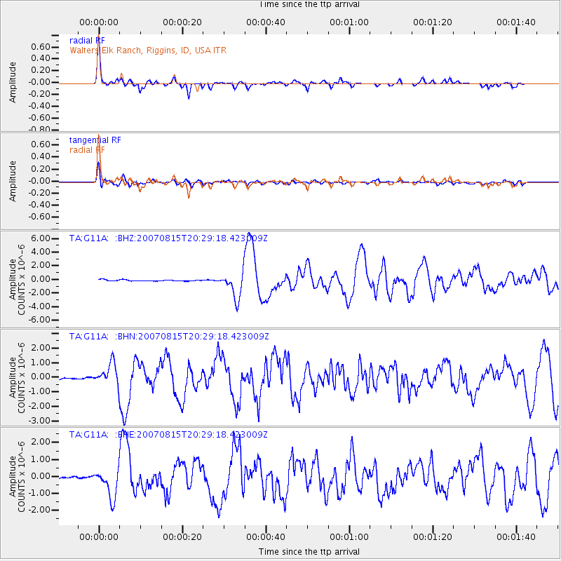
Signal To Noise
| Channel | StoN | STA | LTA |
| TA:G11A: :BHN:20070815T20:29:18.423009Z | 3.1540744 | 7.988638E-7 | 2.5327995E-7 |
| TA:G11A: :BHE:20070815T20:29:18.423009Z | 11.581756 | 8.944138E-7 | 7.72261E-8 |
| TA:G11A: :BHZ:20070815T20:29:18.423009Z | 22.231152 | 2.0122009E-6 | 9.051267E-8 |
| Arrivals |
| Ps | 7.2 SECOND |
| PpPs | 18 SECOND |
| PsPs/PpSs | 25 SECOND |


