You are here: Home > Network List > TA - USArray Transportable Network (new EarthScope stations) Stations List
> Station B04A Port Angeles, WA, USA > Earthquake Result Viewer
B04A Port Angeles, WA, USA - Earthquake Result Viewer

| Earthquake location: |
Chile-Bolivia Border Region |
| Earthquake latitude/longitude: |
-22.3/-67.9 |
| Earthquake time(UTC): |
2005/11/17 (321) 19:26:56 GMT |
| Earthquake Depth: |
163 km |
| Earthquake Magnitude: |
6.0 MB, 6.9 MW, 6.8 MW |
| Earthquake Catalog/Contributor: |
WHDF/NEIC |
|
| Network: |
TA USArray Transportable Network (new EarthScope stations) |
| Station: |
B04A Port Angeles, WA, USA |
| Lat/Lon: |
48.06 N/123.50 W |
| Elevation: |
294 m |
|
| Distance: |
85.9 deg |
| Az: |
326.286 deg |
| Baz: |
129.994 deg |
| Ray Param: |
0.044039488 |
| Estimated Moho Depth: |
32.25 km |
| Estimated Crust Vp/Vs: |
1.92 |
| Assumed Crust Vp: |
6.566 km/s |
| Estimated Crust Vs: |
3.411 km/s |
| Estimated Crust Poisson's Ratio: |
0.32 |
|
| Radial Match: |
91.55725 % |
| Radial Bump: |
400 |
| Transverse Match: |
84.68933 % |
| Transverse Bump: |
400 |
| SOD ConfigId: |
2422 |
| Insert Time: |
2010-03-07 03:10:39.505 +0000 |
| GWidth: |
2.5 |
| Max Bumps: |
400 |
| Tol: |
0.001 |
|
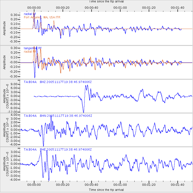
Signal To Noise
| Channel | StoN | STA | LTA |
| TA:B04A: :BHN:20051117T19:38:46.974006Z | 3.3374627 | 6.4893277E-7 | 1.9443897E-7 |
| TA:B04A: :BHE:20051117T19:38:46.974006Z | 4.6839986 | 1.2891214E-6 | 2.7521816E-7 |
| TA:B04A: :BHZ:20051117T19:38:46.974006Z | 25.755545 | 4.8905745E-6 | 1.8988433E-7 |
| Arrivals |
| Ps | 4.6 SECOND |
| PpPs | 14 SECOND |
| PsPs/PpSs | 19 SECOND |


