
Station TA B04A - Port Angeles, WA, USA
Network: TA - USArray Transportable Network (new EarthScope stations)
Nearby stations (2 deg radius)
| Station | Name | (Lat, Lon) | Start / End | Elevation |
| B04A | Port Angeles, WA, USA | (48.06, -123.50) | 2005-10-21 / 2499-01-01 | 294 m |
| Crust2 Type: | L8,thin continental arc, Cordilleras, 0.5 km seds. |
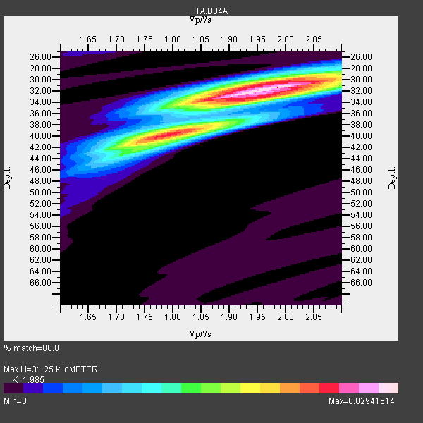
| Thickness Estimate: | 31 km |
| Thickness StdDev: | 3.0 km |
| Vp/Vs Estimate: | 1.99 |
| Vp/Vs StdDev: | 0.07 |
| Vs Estimate: | 3.308 km/s |
| Poisson's Ratio: | 0.33 |
| Peak Value: | 0.03 |
| Assumed Vp: | 6.566 km/s |
| Ps Weight: | 0.33333334 |
| PpPs Weight: | 0.33333334 |
| PsPs Weight: | 0.33333328 |
| Residual Complexity: | 0.643 |
| Nearby stations H: | +- |
| (2.0 deg) Vp/Vs: | +- |
9 with match > 90% ( 40.909092 %) and 22 with match > 80% ( 100.0 %) out of 22.
Download stack as xyz text file.
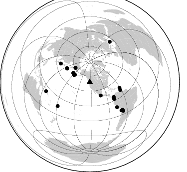
Azimuth Distribution of Events:
Prior Results for this Station
| Study | Thickness | Vp/Vs | Vp | Vs | Poissons Ratio | Extra |
| EARS | 31 km | 1.99 | 6.566 km/s | 3.308 km/s | 0.33 | |
| Crust2.0 | 34 km | 1.77 | 6.566 km/s | 3.707 km/s | 0.27 | L8,thin continental arc, Cordilleras, 0.5 km seds. |
| Global Maxima | 31 km | 1.99 | 6.566 km/s | 3.308 km/s | 0.33 | amp=0.02941814 |
| Local Maxima 1 | 40 km | 1.81 | 6.566 km/s | 3.623 km/s | 0.28 | amp=0.020232407 |
| Local Maxima 2 | 30 km | 1.98 | 6.566 km/s | 3.325 km/s | 0.33 | amp=0.014054134 |
| Local Maxima 3 | 32 km | 2.00 | 6.566 km/s | 3.287 km/s | 0.33 | amp=0.011639364 |
| Local Maxima 4 | 43 km | 1.71 | 6.566 km/s | 3.845 km/s | 0.24 | amp=0.008764281 |
| Predicted Arrivals for vertical incidence (zero ray parameter) | |
| Ps | 4.69 SECOND |
| PpPs | 14.21 SECOND |
| PsPs/PpSs | 18.89 SECOND |
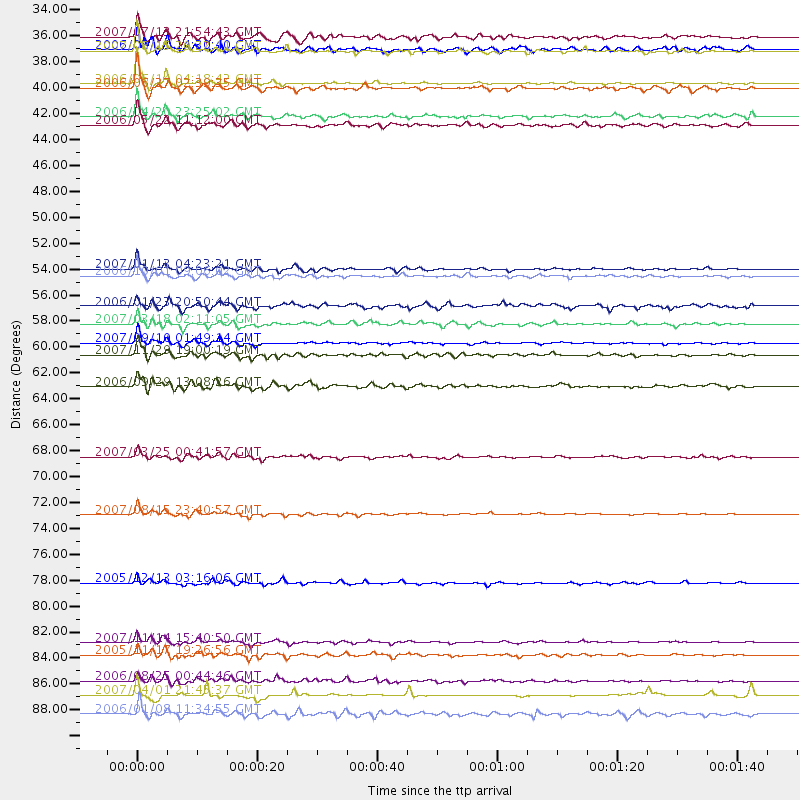
Events Processed for this Station
Download zip of receiver functions as SAC
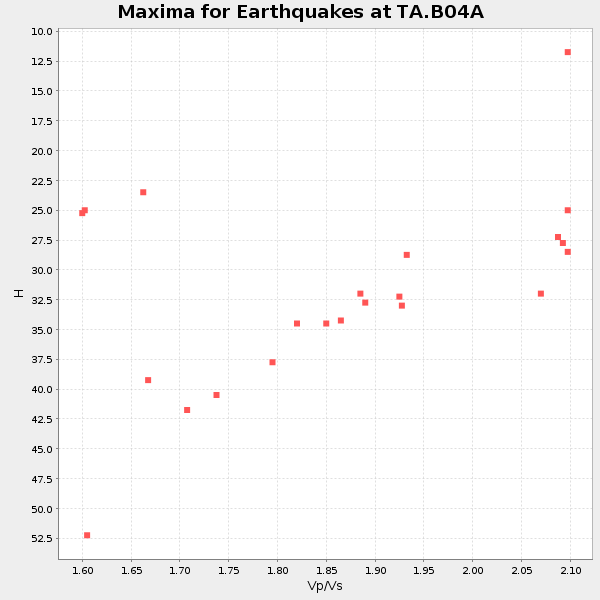
Plot maxima for each earthquake.
Events Used in the Stack
(22 events)| Radial Match | Distance | Baz | FERegion | Time | Lat/Lon | Depth | Magnitude |
| 95.93855 | 59.5 deg | 124.183 deg | Near West Coast Of Colombia | 2007/09/10 01:49:14 GMT | (3.0, -78.0) | 31 km | 6.1 MB, 6.7 MS, 6.8 MW |
| 95.55514 | 84.9 deg | 131.511 deg | Northern Chile | 2007/11/14 15:40:50 GMT | (-22.2, -69.9) | 40 km | 6.7 MB, 7.4 MS, 7.7 MW, 7.4 ME |
| 95.409 | 53.2 deg | 300.889 deg | East Of Kuril Islands | 2007/01/13 04:23:21 GMT | (46.2, 154.5) | 10 km | 7.3 MB, 8.2 MS, 8.1 MW, 7.9 MW |
| 93.890625 | 37.5 deg | 298.531 deg | Rat Islands, Aleutian Islands | 2006/06/14 04:18:42 GMT | (51.8, 177.1) | 14 km | 5.9 MB, 6.4 MS, 6.4 MW, 6.4 MW |
| 93.14697 | 60.5 deg | 100.698 deg | Windward Islands | 2007/11/29 19:00:19 GMT | (15.0, -61.3) | 148 km | 6.9 MB, 7.4 MW, 7.4 MW |
| 92.02144 | 74.0 deg | 132.337 deg | Near Coast Of Peru | 2007/08/15 23:40:57 GMT | (-13.4, -76.6) | 39 km | 6.7 MB, 7.9 MS, 8.0 MW, 7.5 ME |
| 91.793655 | 88.1 deg | 130.496 deg | Chile-Argentina Border Region | 2006/08/25 00:44:46 GMT | (-24.4, -67.0) | 184 km | 5.9 MB, 6.6 MW, 6.6 MW |
| 91.55725 | 85.9 deg | 129.994 deg | Chile-Bolivia Border Region | 2005/11/17 19:26:56 GMT | (-22.3, -67.9) | 163 km | 6.0 MB, 6.9 MW, 6.8 MW |
| 90.844185 | 53.8 deg | 301.744 deg | Kuril Islands | 2006/10/01 09:06:02 GMT | (46.5, 153.2) | 19 km | 6.1 MB, 6.4 MS, 6.6 MW, 6.5 MW |
| 89.94702 | 89.3 deg | 258.347 deg | Solomon Islands | 2007/04/01 21:45:37 GMT | (-7.3, 155.6) | 10 km | 5.7 MB |
| 89.76838 | 57.9 deg | 123.662 deg | South Of Panama | 2007/03/18 02:11:05 GMT | (4.6, -78.5) | 8.0 km | 6.4 MB, 5.7 MS, 6.2 MW, 6.1 MW |
| 89.367714 | 34.7 deg | 294.439 deg | Andreanof Islands, Aleutian Is. | 2007/08/15 20:22:11 GMT | (50.3, -177.5) | 9.0 km | 6.3 MB, 6.2 MS, 6.4 MW, 5.9 ML |
| 88.829185 | 33.6 deg | 296.635 deg | Andreanof Islands, Aleutian Is. | 2007/07/13 21:54:43 GMT | (51.8, -176.3) | 35 km | 5.7 MB, 5.6 MS, 6.0 MW, 5.9 MW |
| 88.39344 | 40.3 deg | 315.083 deg | Eastern Siberia, Russia | 2006/04/20 23:25:02 GMT | (60.9, 167.1) | 22 km | 6.8 MB, 7.6 MS, 7.6 MW, 7.3 MW |
| 85.09181 | 41.0 deg | 315.072 deg | Eastern Siberia, Russia | 2006/05/22 11:12:00 GMT | (60.8, 165.7) | 16 km | 6.0 MB, 6.7 MS, 6.6 MW, 6.5 MW |
| 84.88095 | 90.9 deg | 26.316 deg | Southern Greece | 2006/01/08 11:34:55 GMT | (36.3, 23.2) | 66 km | 6.5 MB, 6.7 MW, 6.7 MW |
| 84.62619 | 63.2 deg | 104.206 deg | Trinidad | 2006/09/29 13:08:26 GMT | (10.9, -61.8) | 53 km | 5.9 MB, 5.4 MS, 6.1 MW, 6.0 MW |
| 83.31992 | 79.8 deg | 233.506 deg | Fiji Islands Region | 2005/12/13 03:16:06 GMT | (-15.3, -178.6) | 10 km | 6.1 MB, 6.8 MS, 6.7 MW, 6.7 MW |
| 82.47117 | 37.9 deg | 299.523 deg | Rat Islands, Aleutian Islands | 2006/06/27 02:39:35 GMT | (52.2, 176.2) | 34 km | 5.6 MB, 6.0 MS, 6.2 MW, 6.2 MW |
| 80.56111 | 34.6 deg | 140.411 deg | Guerrero, Mexico | 2006/08/11 14:30:40 GMT | (18.6, -101.1) | 60 km | 6.0 MB, 6.1 MW, 6.0 MW |
| 80.54176 | 56.4 deg | 121.439 deg | Near West Coast Of Colombia | 2006/01/23 20:50:44 GMT | (6.9, -77.8) | 14 km | 6.1 MB, 5.9 MS, 6.2 MW, 6.1 MW |
| 80.393585 | 69.2 deg | 302.844 deg | Near West Coast Of Honshu, Japan | 2007/03/25 00:41:57 GMT | (37.3, 136.6) | 8.0 km | 6.1 MB, 6.8 MS, 6.7 MW, 6.6 MW |
Losers
(0 events)| Radial Match | Distance | Baz | FERegion | Time | Lat/Lon | Depth | Magnitude | Reason |
