You are here: Home > Network List > TA - USArray Transportable Network (new EarthScope stations) Stations List
> Station B04A Port Angeles, WA, USA > Earthquake Result Viewer
B04A Port Angeles, WA, USA - Earthquake Result Viewer
| Earthquake location: |
Windward Islands |
| Earthquake latitude/longitude: |
15.0/-61.3 |
| Earthquake time(UTC): |
2007/11/29 (333) 19:00:19 GMT |
| Earthquake Depth: |
148 km |
| Earthquake Magnitude: |
6.9 MB, 7.4 MW, 7.4 MW |
| Earthquake Catalog/Contributor: |
WHDF/NEIC |
|
| Network: |
TA USArray Transportable Network (new EarthScope stations) |
| Station: |
B04A Port Angeles, WA, USA |
| Lat/Lon: |
48.06 N/123.50 W |
| Elevation: |
294 m |
|
| Distance: |
60.5 deg |
| Az: |
316.994 deg |
| Baz: |
100.698 deg |
| Ray Param: |
0.061037455 |
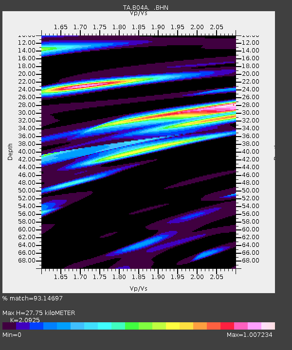
| Estimated Moho Depth: |
27.75 km |
| Estimated Crust Vp/Vs: |
2.09 |
| Assumed Crust Vp: |
6.566 km/s |
| Estimated Crust Vs: |
3.138 km/s |
| Estimated Crust Poisson's Ratio: |
0.35 |
|
| Radial Match: |
93.14697 % |
| Radial Bump: |
400 |
| Transverse Match: |
84.24967 % |
| Transverse Bump: |
400 |
| SOD ConfigId: |
2564 |
| Insert Time: |
2010-03-07 03:10:42.614 +0000 |
| GWidth: |
2.5 |
| Max Bumps: |
400 |
| Tol: |
0.001 |
|

Signal To Noise
| Channel | StoN | STA | LTA |
| TA:B04A: :BHN:20071129T19:09:43.373022Z | 4.3240633 | 2.7286483E-6 | 6.3103806E-7 |
| TA:B04A: :BHE:20071129T19:09:43.373022Z | 14.489796 | 5.3029007E-6 | 3.659748E-7 |
| TA:B04A: :BHZ:20071129T19:09:43.373022Z | 17.686329 | 8.982493E-6 | 5.078777E-7 |
| Arrivals |
| Ps | 4.8 SECOND |
| PpPs | 13 SECOND |
| PsPs/PpSs | 17 SECOND |


