You are here: Home > Network List > TA - USArray Transportable Network (new EarthScope stations) Stations List
> Station L22K Petersville, AK, USA > Earthquake Result Viewer
L22K Petersville, AK, USA - Earthquake Result Viewer
| Earthquake location: |
Turkey |
| Earthquake latitude/longitude: |
37.9/29.7 |
| Earthquake time(UTC): |
2019/08/08 (220) 11:25:31 GMT |
| Earthquake Depth: |
10 km |
| Earthquake Magnitude: |
5.8 Mww |
| Earthquake Catalog/Contributor: |
NEIC PDE/us |
|
| Network: |
TA USArray Transportable Network (new EarthScope stations) |
| Station: |
L22K Petersville, AK, USA |
| Lat/Lon: |
62.53 N/150.77 W |
| Elevation: |
817 m |
|
| Distance: |
79.9 deg |
| Az: |
0.22 deg |
| Baz: |
359.625 deg |
| Ray Param: |
0.04866497 |
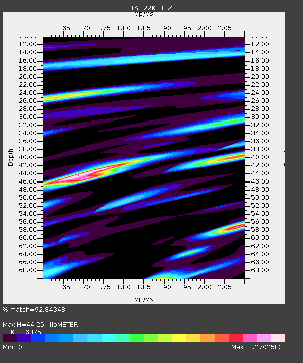
| Estimated Moho Depth: |
44.25 km |
| Estimated Crust Vp/Vs: |
1.69 |
| Assumed Crust Vp: |
6.438 km/s |
| Estimated Crust Vs: |
3.815 km/s |
| Estimated Crust Poisson's Ratio: |
0.23 |
|
| Radial Match: |
92.84348 % |
| Radial Bump: |
400 |
| Transverse Match: |
82.56115 % |
| Transverse Bump: |
400 |
| SOD ConfigId: |
19053131 |
| Insert Time: |
2019-08-22 11:38:15.058 +0000 |
| GWidth: |
2.5 |
| Max Bumps: |
400 |
| Tol: |
0.001 |
|

Signal To Noise
| Channel | StoN | STA | LTA |
| TA:L22K: :BHZ:20190808T11:37:08.349989Z | 15.5068035 | 8.6460597E-7 | 5.575656E-8 |
| TA:L22K: :BHN:20190808T11:37:08.349989Z | 6.6496625 | 3.702426E-7 | 5.56784E-8 |
| TA:L22K: :BHE:20190808T11:37:08.349989Z | 1.6677542 | 1.3344399E-7 | 8.001419E-8 |
| Arrivals |
| Ps | 4.9 SECOND |
| PpPs | 18 SECOND |
| PsPs/PpSs | 23 SECOND |


