B04A Port Angeles, WA, USA - Earthquake Result Viewer
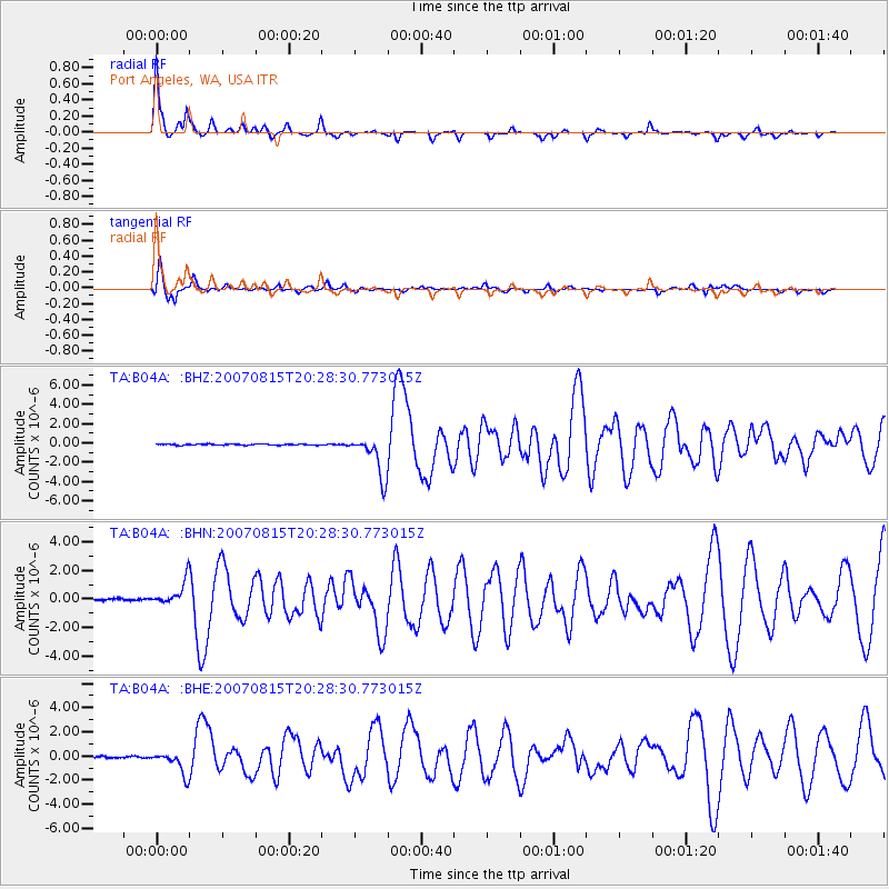
Earthquake location: Andreanof Islands, Aleutian Is.
Earthquake latitude/longitude: 50.3/-177.5
Earthquake time(UTC): 2007/08/15 (227) 20:22:11 GMT
Earthquake Depth: 9.0 km
Earthquake Magnitude: 6.3 MB, 6.2 MS, 6.4 MW, 5.9 ML
Earthquake Catalog/Contributor: WHDF/NEIC
Network: TA USArray Transportable Network (new EarthScope stations)
Station: B04A Port Angeles, WA, USA
Lat/Lon: 48.06 N/123.50 W
Elevation: 294 m
Distance: 34.7 deg
Az: 72.327 deg
Baz: 294.439 deg
Ray Param: 0.077584684
Estimated Moho Depth: 32.0 km
Estimated Crust Vp/Vs: 1.88
Assumed Crust Vp: 6.566 km/s
Estimated Crust Vs: 3.483 km/s
Estimated Crust Poisson's Ratio: 0.30
Radial Match: 89.367714 %
Radial Bump: 221
Transverse Match: 85.60023 %
Transverse Bump: 374
SOD ConfigId: 2564
Insert Time: 2010-03-07 03:10:49.959 +0000
GWidth: 2.5
Max Bumps: 400
Tol: 0.001

Signal To Noise

ChannelStoNSTALTA
TA:B04A: :BHN:20070815T20:28:30.773015Z5.15351729.3402406E-71.8124011E-7
TA:B04A: :BHE:20070815T20:28:30.773015Z14.5690099.220901E-76.32912E-8
TA:B04A: :BHZ:20070815T20:28:30.773015Z37.148532.1471278E-65.7798463E-8
Arrivals
Ps4.7 SECOND
PpPs13 SECOND
PsPs/PpSs18 SECOND