You are here: Home > Network List > TA - USArray Transportable Network (new EarthScope stations) Stations List
> Station B04A Port Angeles, WA, USA > Earthquake Result Viewer
B04A Port Angeles, WA, USA - Earthquake Result Viewer
| Earthquake location: |
Solomon Islands |
| Earthquake latitude/longitude: |
-7.3/155.6 |
| Earthquake time(UTC): |
2007/04/01 (091) 21:45:37 GMT |
| Earthquake Depth: |
10 km |
| Earthquake Magnitude: |
5.7 MB |
| Earthquake Catalog/Contributor: |
WHDF/NEIC |
|
| Network: |
TA USArray Transportable Network (new EarthScope stations) |
| Station: |
B04A Port Angeles, WA, USA |
| Lat/Lon: |
48.06 N/123.50 W |
| Elevation: |
294 m |
|
| Distance: |
89.3 deg |
| Az: |
41.481 deg |
| Baz: |
258.347 deg |
| Ray Param: |
0.04193513 |
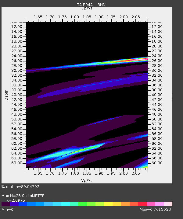
| Estimated Moho Depth: |
25.0 km |
| Estimated Crust Vp/Vs: |
2.10 |
| Assumed Crust Vp: |
6.566 km/s |
| Estimated Crust Vs: |
3.13 km/s |
| Estimated Crust Poisson's Ratio: |
0.35 |
|
| Radial Match: |
89.94702 % |
| Radial Bump: |
280 |
| Transverse Match: |
89.29722 % |
| Transverse Bump: |
327 |
| SOD ConfigId: |
2564 |
| Insert Time: |
2010-03-07 03:10:52.668 +0000 |
| GWidth: |
2.5 |
| Max Bumps: |
400 |
| Tol: |
0.001 |
|

Signal To Noise
| Channel | StoN | STA | LTA |
| TA:B04A: :BHN:20070401T21:58:02.475Z | 1.5822229 | 1.1931774E-5 | 7.5411454E-6 |
| TA:B04A: :BHE:20070401T21:58:02.475Z | 1.7408073 | 3.432887E-5 | 1.9720086E-5 |
| TA:B04A: :BHZ:20070401T21:58:02.475Z | 0.9207036 | 2.418327E-5 | 2.6266074E-5 |
| Arrivals |
| Ps | 4.3 SECOND |
| PpPs | 12 SECOND |
| PsPs/PpSs | 16 SECOND |


