You are here: Home > Network List > TA - USArray Transportable Network (new EarthScope stations) Stations List
> Station B04A Port Angeles, WA, USA > Earthquake Result Viewer
B04A Port Angeles, WA, USA - Earthquake Result Viewer
| Earthquake location: |
South Of Panama |
| Earthquake latitude/longitude: |
4.6/-78.5 |
| Earthquake time(UTC): |
2007/03/18 (077) 02:11:05 GMT |
| Earthquake Depth: |
8.0 km |
| Earthquake Magnitude: |
6.4 MB, 5.7 MS, 6.2 MW, 6.1 MW |
| Earthquake Catalog/Contributor: |
WHDF/NEIC |
|
| Network: |
TA USArray Transportable Network (new EarthScope stations) |
| Station: |
B04A Port Angeles, WA, USA |
| Lat/Lon: |
48.06 N/123.50 W |
| Elevation: |
294 m |
|
| Distance: |
57.9 deg |
| Az: |
325.934 deg |
| Baz: |
123.662 deg |
| Ray Param: |
0.06321509 |
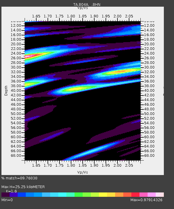
| Estimated Moho Depth: |
25.25 km |
| Estimated Crust Vp/Vs: |
1.60 |
| Assumed Crust Vp: |
6.566 km/s |
| Estimated Crust Vs: |
4.104 km/s |
| Estimated Crust Poisson's Ratio: |
0.18 |
|
| Radial Match: |
89.76838 % |
| Radial Bump: |
400 |
| Transverse Match: |
90.46256 % |
| Transverse Bump: |
400 |
| SOD ConfigId: |
2564 |
| Insert Time: |
2010-03-07 03:10:54.977 +0000 |
| GWidth: |
2.5 |
| Max Bumps: |
400 |
| Tol: |
0.001 |
|
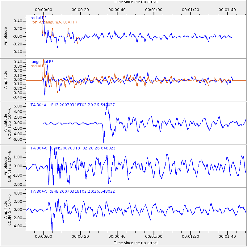
Signal To Noise
| Channel | StoN | STA | LTA |
| TA:B04A: :BHN:20070318T02:20:26.64802Z | 4.3566904 | 8.127953E-7 | 1.8656256E-7 |
| TA:B04A: :BHE:20070318T02:20:26.64802Z | 8.314023 | 1.6765712E-6 | 2.0165584E-7 |
| TA:B04A: :BHZ:20070318T02:20:26.64802Z | 16.21914 | 3.478116E-6 | 2.1444517E-7 |
| Arrivals |
| Ps | 2.4 SECOND |
| PpPs | 9.4 SECOND |
| PsPs/PpSs | 12 SECOND |


