You are here: Home > Network List > TA - USArray Transportable Network (new EarthScope stations) Stations List
> Station B04A Port Angeles, WA, USA > Earthquake Result Viewer
B04A Port Angeles, WA, USA - Earthquake Result Viewer
| Earthquake location: |
Kuril Islands |
| Earthquake latitude/longitude: |
46.5/153.2 |
| Earthquake time(UTC): |
2006/10/01 (274) 09:06:02 GMT |
| Earthquake Depth: |
19 km |
| Earthquake Magnitude: |
6.1 MB, 6.4 MS, 6.6 MW, 6.5 MW |
| Earthquake Catalog/Contributor: |
WHDF/NEIC |
|
| Network: |
TA USArray Transportable Network (new EarthScope stations) |
| Station: |
B04A Port Angeles, WA, USA |
| Lat/Lon: |
48.06 N/123.50 W |
| Elevation: |
294 m |
|
| Distance: |
53.8 deg |
| Az: |
55.633 deg |
| Baz: |
301.744 deg |
| Ray Param: |
0.06582447 |
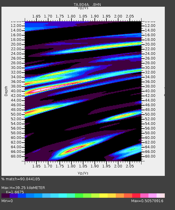
| Estimated Moho Depth: |
39.25 km |
| Estimated Crust Vp/Vs: |
1.67 |
| Assumed Crust Vp: |
6.566 km/s |
| Estimated Crust Vs: |
3.938 km/s |
| Estimated Crust Poisson's Ratio: |
0.22 |
|
| Radial Match: |
90.844185 % |
| Radial Bump: |
400 |
| Transverse Match: |
81.90325 % |
| Transverse Bump: |
400 |
| SOD ConfigId: |
2665 |
| Insert Time: |
2010-03-07 03:10:59.737 +0000 |
| GWidth: |
2.5 |
| Max Bumps: |
400 |
| Tol: |
0.001 |
|
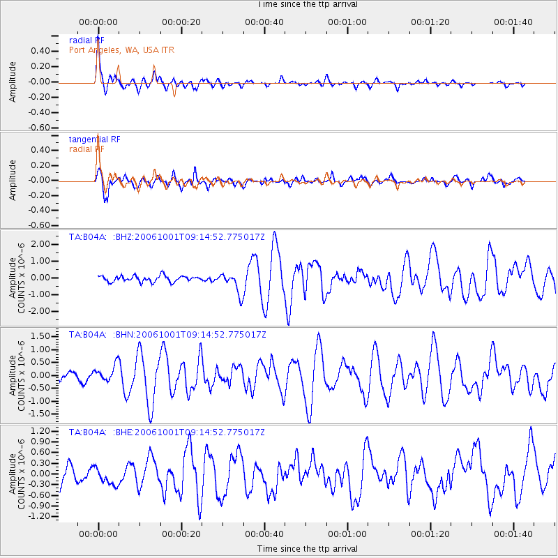
Signal To Noise
| Channel | StoN | STA | LTA |
| TA:B04A: :BHN:20061001T09:14:52.775017Z | 1.1350055 | 3.189192E-7 | 2.8098472E-7 |
| TA:B04A: :BHE:20061001T09:14:52.775017Z | 0.9729412 | 2.3816033E-7 | 2.447839E-7 |
| TA:B04A: :BHZ:20061001T09:14:52.775017Z | 3.704101 | 6.605565E-7 | 1.783311E-7 |
| Arrivals |
| Ps | 4.2 SECOND |
| PpPs | 15 SECOND |
| PsPs/PpSs | 19 SECOND |


