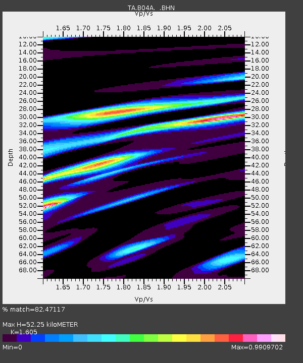
B04A Port Angeles, WA, USA - Earthquake Result Viewer
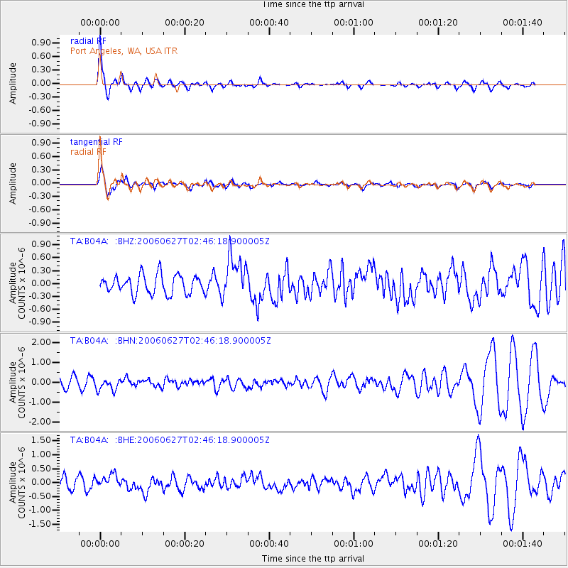
Earthquake location: Rat Islands, Aleutian Islands
Earthquake latitude/longitude: 52.2/176.2
Earthquake time(UTC): 2006/06/27 (178) 02:39:35 GMT
Earthquake Depth: 34 km
Earthquake Magnitude: 5.6 MB, 6.0 MS, 6.2 MW, 6.2 MW
Earthquake Catalog/Contributor: WHDF/NEIC
Network: TA USArray Transportable Network (new EarthScope stations)
Station: B04A Port Angeles, WA, USA
Lat/Lon: 48.06 N/123.50 W
Elevation: 294 m
Distance: 37.9 deg
Az: 71.546 deg
Baz: 299.523 deg
Ray Param: 0.075801775
Estimated Moho Depth: 52.25 km
Estimated Crust Vp/Vs: 1.61
Assumed Crust Vp: 6.566 km/s
Estimated Crust Vs: 4.091 km/s
Estimated Crust Poisson's Ratio: 0.18
Radial Match: 82.47117 %
Radial Bump: 314
Transverse Match: 81.02688 %
Transverse Bump: 400
SOD ConfigId: 2665
Insert Time: 2010-03-07 03:11:05.914 +0000
GWidth: 2.5
Max Bumps: 400
Tol: 0.001

Signal To Noise

ChannelStoNSTALTA
TA:B04A: :BHN:20060627T02:46:18.900005Z1.57183473.0905252E-71.9661897E-7
TA:B04A: :BHE:20060627T02:46:18.900005Z1.01909432.458605E-72.412539E-7
TA:B04A: :BHZ:20060627T02:46:18.900005Z2.2806444.9286183E-72.1610643E-7
Arrivals
Ps5.2 SECOND
PpPs19 SECOND
PsPs/PpSs24 SECOND