You are here: Home > Network List > TA - USArray Transportable Network (new EarthScope stations) Stations List
> Station B04A Port Angeles, WA, USA > Earthquake Result Viewer
B04A Port Angeles, WA, USA - Earthquake Result Viewer
| Earthquake location: |
Eastern Siberia, Russia |
| Earthquake latitude/longitude: |
60.9/167.1 |
| Earthquake time(UTC): |
2006/04/20 (110) 23:25:02 GMT |
| Earthquake Depth: |
22 km |
| Earthquake Magnitude: |
6.8 MB, 7.6 MS, 7.6 MW, 7.3 MW |
| Earthquake Catalog/Contributor: |
WHDF/NEIC |
|
| Network: |
TA USArray Transportable Network (new EarthScope stations) |
| Station: |
B04A Port Angeles, WA, USA |
| Lat/Lon: |
48.06 N/123.50 W |
| Elevation: |
294 m |
|
| Distance: |
40.3 deg |
| Az: |
76.049 deg |
| Baz: |
315.083 deg |
| Ray Param: |
0.07443626 |
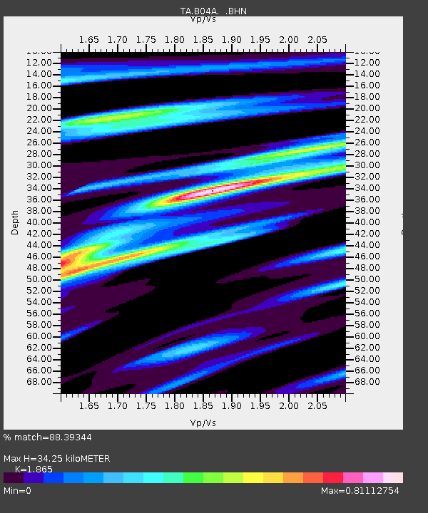
| Estimated Moho Depth: |
34.25 km |
| Estimated Crust Vp/Vs: |
1.87 |
| Assumed Crust Vp: |
6.566 km/s |
| Estimated Crust Vs: |
3.521 km/s |
| Estimated Crust Poisson's Ratio: |
0.30 |
|
| Radial Match: |
88.39344 % |
| Radial Bump: |
400 |
| Transverse Match: |
82.0918 % |
| Transverse Bump: |
400 |
| SOD ConfigId: |
2669 |
| Insert Time: |
2010-03-07 03:11:10.372 +0000 |
| GWidth: |
2.5 |
| Max Bumps: |
400 |
| Tol: |
0.001 |
|
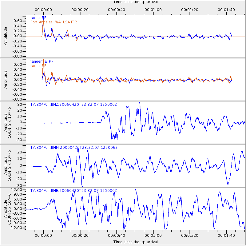
Signal To Noise
| Channel | StoN | STA | LTA |
| TA:B04A: :BHN:20060420T23:32:07.125006Z | 14.328992 | 5.319536E-6 | 3.7124286E-7 |
| TA:B04A: :BHE:20060420T23:32:07.125006Z | 7.6239605 | 3.2605212E-6 | 4.2766766E-7 |
| TA:B04A: :BHZ:20060420T23:32:07.125006Z | 28.071846 | 9.536106E-6 | 3.3970355E-7 |
| Arrivals |
| Ps | 4.8 SECOND |
| PpPs | 14 SECOND |
| PsPs/PpSs | 19 SECOND |


