You are here: Home > Network List > TA - USArray Transportable Network (new EarthScope stations) Stations List
> Station B06A Marblemount, WA, USA > Earthquake Result Viewer
B06A Marblemount, WA, USA - Earthquake Result Viewer
| Earthquake location: |
Northern Chile |
| Earthquake latitude/longitude: |
-22.2/-69.9 |
| Earthquake time(UTC): |
2007/11/14 (318) 15:40:50 GMT |
| Earthquake Depth: |
40 km |
| Earthquake Magnitude: |
6.7 MB, 7.4 MS, 7.7 MW, 7.4 ME |
| Earthquake Catalog/Contributor: |
WHDF/NEIC |
|
| Network: |
TA USArray Transportable Network (new EarthScope stations) |
| Station: |
B06A Marblemount, WA, USA |
| Lat/Lon: |
48.52 N/121.48 W |
| Elevation: |
75 m |
|
| Distance: |
84.2 deg |
| Az: |
328.418 deg |
| Baz: |
133.134 deg |
| Ray Param: |
0.045609117 |
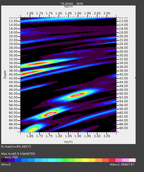
| Estimated Moho Depth: |
60.5 km |
| Estimated Crust Vp/Vs: |
1.75 |
| Assumed Crust Vp: |
6.566 km/s |
| Estimated Crust Vs: |
3.741 km/s |
| Estimated Crust Poisson's Ratio: |
0.26 |
|
| Radial Match: |
95.46572 % |
| Radial Bump: |
400 |
| Transverse Match: |
91.2721 % |
| Transverse Bump: |
400 |
| SOD ConfigId: |
2564 |
| Insert Time: |
2010-03-07 03:14:35.180 +0000 |
| GWidth: |
2.5 |
| Max Bumps: |
400 |
| Tol: |
0.001 |
|
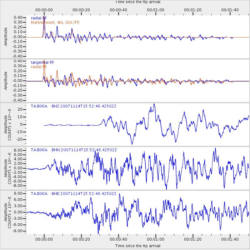
Signal To Noise
| Channel | StoN | STA | LTA |
| TA:B06A: :BHN:20071114T15:52:46.42502Z | 4.732878 | 9.523438E-7 | 2.0121874E-7 |
| TA:B06A: :BHE:20071114T15:52:46.42502Z | 5.4778075 | 1.0124295E-6 | 1.8482385E-7 |
| TA:B06A: :BHZ:20071114T15:52:46.42502Z | 14.348186 | 4.5016973E-6 | 3.1374682E-7 |
| Arrivals |
| Ps | 7.1 SECOND |
| PpPs | 25 SECOND |
| PsPs/PpSs | 32 SECOND |


