
Station TA B06A - Marblemount, WA, USA
Network: TA - USArray Transportable Network (new EarthScope stations)
Nearby stations (2 deg radius)
| Station | Name | (Lat, Lon) | Start / End | Elevation |
| B06A | Marblemount, WA, USA | (48.52, -121.48) | 2006-09-17 / 2499-01-01 | 0.1 km |
| Crust2 Type: | L8,thin continental arc, Cordilleras, 0.5 km seds. |
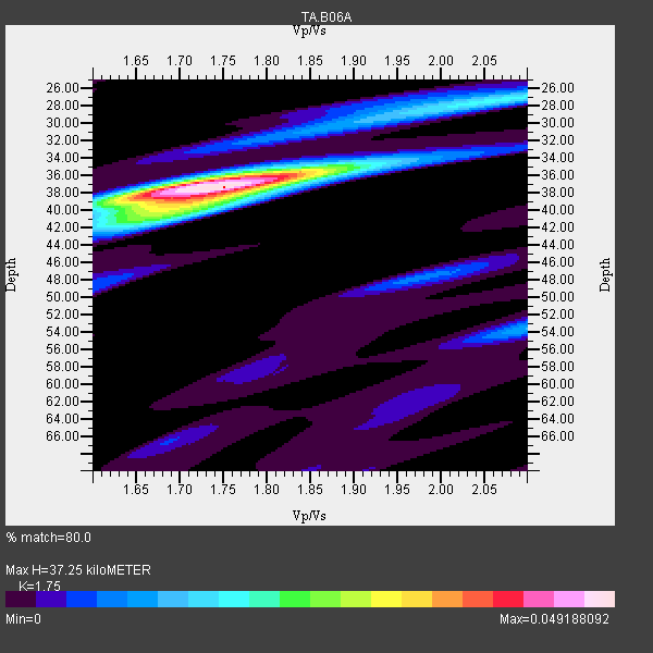
| Thickness Estimate: | 37 km |
| Thickness StdDev: | 0.3 km |
| Vp/Vs Estimate: | 1.75 |
| Vp/Vs StdDev: | 0.02 |
| Vs Estimate: | 3.752 km/s |
| Poisson's Ratio: | 0.26 |
| Peak Value: | 0.05 |
| Assumed Vp: | 6.566 km/s |
| Ps Weight: | 0.33333334 |
| PpPs Weight: | 0.33333334 |
| PsPs Weight: | 0.33333328 |
| Residual Complexity: | 0.456 |
| Nearby stations H: | 37 km +- 0.0 km |
| (2.0 deg) Vp/Vs: | 1.75 +- 0.01 |
9 with match > 90% ( 47.36842 %) and 19 with match > 80% ( 100.0 %) out of 19.
Download stack as xyz text file.
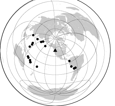
Azimuth Distribution of Events:
Prior Results for this Station
| Study | Thickness | Vp/Vs | Vp | Vs | Poissons Ratio | Extra |
| EARS | 37 km | 1.75 | 6.566 km/s | 3.752 km/s | 0.26 | |
| Crust2.0 | 34 km | 1.77 | 6.566 km/s | 3.707 km/s | 0.27 | L8,thin continental arc, Cordilleras, 0.5 km seds. |
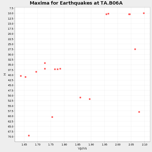
| Global Maxima | 37 km | 1.75 | 6.566 km/s | 3.752 km/s | 0.26 | amp=0.049188092 |
| Local Maxima 1 | 37 km | 1.70 | 6.566 km/s | 3.874 km/s | 0.23 | amp=0.026673479 |
| Local Maxima 2 | 27 km | 2.07 | 6.566 km/s | 3.176 km/s | 0.35 | amp=0.016502213 |
| Local Maxima 3 | 40 km | 1.68 | 6.566 km/s | 3.908 km/s | 0.23 | amp=0.01558414 |
| Local Maxima 4 | 54 km | 2.10 | 6.566 km/s | 3.13 km/s | 0.35 | amp=0.012341342 |
| Predicted Arrivals for vertical incidence (zero ray parameter) | |
| Ps | 4.25 SECOND |
| PpPs | 15.60 SECOND |
| PsPs/PpSs | 19.86 SECOND |
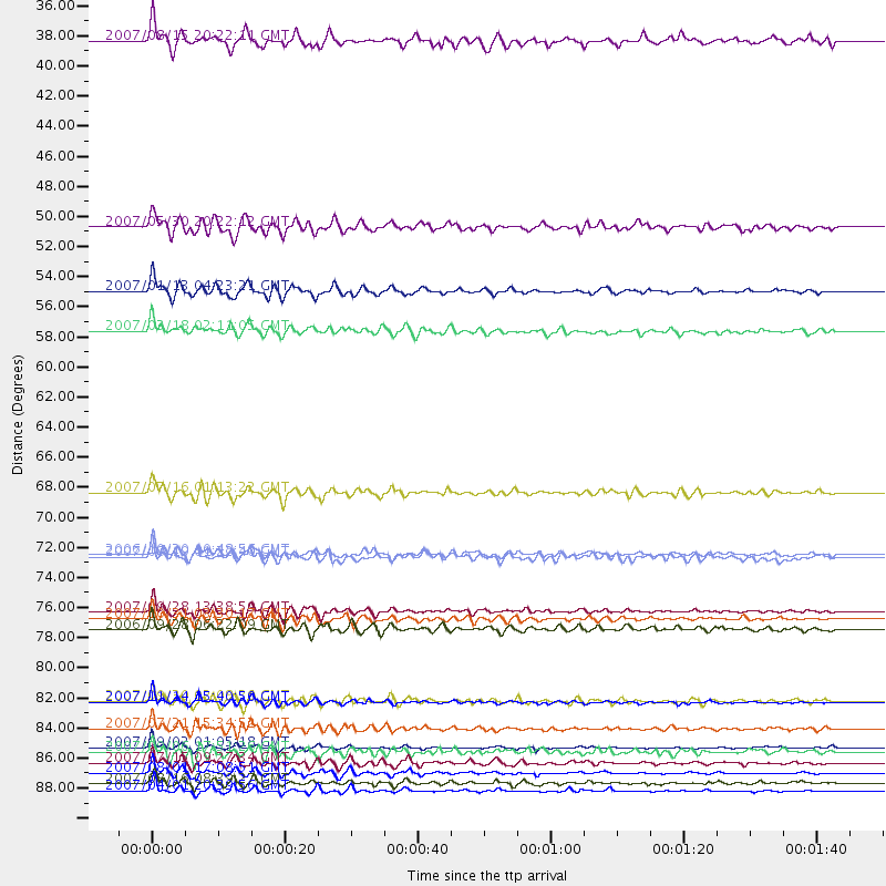
Events Processed for this Station
Download zip of receiver functions as SAC
Plot maxima for each earthquake.
Events Used in the Stack
(19 events)| Radial Match | Distance | Baz | FERegion | Time | Lat/Lon | Depth | Magnitude |
| 97.26249 | 87.5 deg | 249.496 deg | Santa Cruz Islands | 2007/09/02 01:05:18 GMT | (-11.6, 165.8) | 35 km | 5.9 MB, 7.3 MS, 7.2 MW, 6.9 ME |
| 96.067276 | 90.7 deg | 258.067 deg | Solomon Islands | 2007/04/01 20:39:56 GMT | (-8.5, 157.0) | 10 km | 6.8 MB, 7.9 MS, 8.1 MW, 7.7 ME |
| 95.46572 | 84.2 deg | 133.134 deg | Northern Chile | 2007/11/14 15:40:50 GMT | (-22.2, -69.9) | 40 km | 6.7 MB, 7.4 MS, 7.7 MW, 7.4 ME |
| 93.6772 | 78.9 deg | 228.992 deg | Samoa Islands Region | 2006/09/28 06:22:09 GMT | (-16.6, -172.0) | 28 km | 6.5 MB, 6.6 MS, 6.9 MW, 6.7 MW |
| 92.97167 | 54.1 deg | 301.588 deg | East Of Kuril Islands | 2007/01/13 04:23:21 GMT | (46.2, 154.5) | 10 km | 7.3 MB, 8.2 MS, 8.1 MW, 7.9 MW |
| 92.549 | 68.9 deg | 302.943 deg | Near West Coast Of Honshu, Japan | 2007/07/16 01:13:22 GMT | (37.5, 138.4) | 12 km | 6.5 MB, 6.4 MS, 6.6 MW, 6.5 MW |
| 92.42342 | 77.6 deg | 289.035 deg | Volcano Islands, Japan Region | 2007/09/28 13:38:59 GMT | (22.0, 142.7) | 276 km | 6.7 MB, 7.4 MW, 7.4 MW |
| 91.4905 | 89.4 deg | 245.547 deg | Vanuatu Islands | 2007/08/01 17:08:51 GMT | (-15.6, 167.7) | 120 km | 6.2 MB, 7.2 MW, 7.2 MW |
| 90.936035 | 90.1 deg | 255.367 deg | Solomon Islands | 2007/08/16 08:39:27 GMT | (-9.8, 159.5) | 10 km | 6.1 MB, 6.7 MS, 6.4 MW |
| 88.0828 | 49.4 deg | 306.657 deg | Kamchatka Peninsula, Russia | 2007/05/30 20:22:12 GMT | (52.1, 157.3) | 116 km | 6.4 MB, 6.4 MW, 6.4 MW |
| 87.07212 | 35.8 deg | 294.557 deg | Andreanof Islands, Aleutian Is. | 2007/08/15 20:22:11 GMT | (50.3, -177.5) | 9.0 km | 6.3 MB, 6.2 MS, 6.4 MW, 5.9 ML |
| 86.04548 | 78.1 deg | 284.978 deg | Mariana Islands | 2007/10/31 03:30:17 GMT | (18.9, 145.4) | 223 km | 6.2 MB, 7.2 MW, 7.2 MW |
| 84.65491 | 57.0 deg | 125.898 deg | South Of Panama | 2007/03/18 02:11:05 GMT | (4.6, -78.5) | 8.0 km | 6.4 MB, 5.7 MS, 6.2 MW, 6.1 MW |
| 83.81783 | 86.1 deg | 129.856 deg | Jujuy Province, Argentina | 2007/07/21 15:34:52 GMT | (-22.2, -65.8) | 290 km | 5.8 MB, 6.4 MW, 6.3 MW |
| 83.81453 | 73.5 deg | 134.343 deg | Near Coast Of Peru | 2007/08/19 01:22:40 GMT | (-13.6, -76.6) | 26 km | 5.9 MB, 5.4 MS, 5.8 MW, 5.5 ML |
| 82.75699 | 88.7 deg | 244.989 deg | Vanuatu Islands | 2007/07/15 09:27:34 GMT | (-15.4, 168.6) | 8.0 km | 6.0 MB, 5.8 MS, 6.1 MW, 6.0 MW |
| 82.51815 | 87.9 deg | 305.082 deg | Taiwan Region | 2007/09/06 17:51:26 GMT | (24.3, 122.2) | 53 km | 6.1 MB, 6.2 MW, 6.1 ME |
| 81.758934 | 84.1 deg | 279.006 deg | South Of Mariana Islands | 2007/09/30 02:08:30 GMT | (10.5, 145.7) | 14 km | 6.4 MB, 7.1 MS, 6.9 MW, 6.9 MW |
| 80.44037 | 73.4 deg | 134.311 deg | Near Coast Of Peru | 2006/10/20 10:48:56 GMT | (-13.5, -76.7) | 23 km | 5.9 MB, 6.6 MS, 6.7 MW, 6.6 MW |
Losers
(0 events)| Radial Match | Distance | Baz | FERegion | Time | Lat/Lon | Depth | Magnitude | Reason |
