You are here: Home > Network List > TA - USArray Transportable Network (new EarthScope stations) Stations List
> Station B06A Marblemount, WA, USA > Earthquake Result Viewer
B06A Marblemount, WA, USA - Earthquake Result Viewer

| Earthquake location: |
Volcano Islands, Japan Region |
| Earthquake latitude/longitude: |
22.0/142.7 |
| Earthquake time(UTC): |
2007/09/28 (271) 13:38:59 GMT |
| Earthquake Depth: |
276 km |
| Earthquake Magnitude: |
6.7 MB, 7.4 MW, 7.4 MW |
| Earthquake Catalog/Contributor: |
WHDF/NEIC |
|
| Network: |
TA USArray Transportable Network (new EarthScope stations) |
| Station: |
B06A Marblemount, WA, USA |
| Lat/Lon: |
48.52 N/121.48 W |
| Elevation: |
75 m |
|
| Distance: |
77.6 deg |
| Az: |
42.63 deg |
| Baz: |
289.035 deg |
| Ray Param: |
0.049488436 |
| Estimated Moho Depth: |
37.25 km |
| Estimated Crust Vp/Vs: |
1.77 |
| Assumed Crust Vp: |
6.566 km/s |
| Estimated Crust Vs: |
3.699 km/s |
| Estimated Crust Poisson's Ratio: |
0.27 |
|
| Radial Match: |
92.42342 % |
| Radial Bump: |
400 |
| Transverse Match: |
76.26656 % |
| Transverse Bump: |
400 |
| SOD ConfigId: |
2564 |
| Insert Time: |
2010-03-07 03:14:42.115 +0000 |
| GWidth: |
2.5 |
| Max Bumps: |
400 |
| Tol: |
0.001 |
|
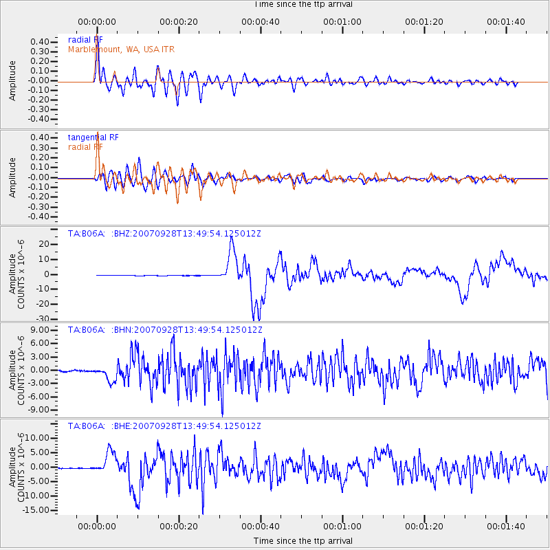
Signal To Noise
| Channel | StoN | STA | LTA |
| TA:B06A: :BHN:20070928T13:49:54.125012Z | 13.051966 | 1.6975413E-6 | 1.300602E-7 |
| TA:B06A: :BHE:20070928T13:49:54.125012Z | 35.946835 | 4.1084904E-6 | 1.1429352E-7 |
| TA:B06A: :BHZ:20070928T13:49:54.125012Z | 78.63116 | 1.1482972E-5 | 1.460359E-7 |
| Arrivals |
| Ps | 4.5 SECOND |
| PpPs | 15 SECOND |
| PsPs/PpSs | 20 SECOND |


