B06A Marblemount, WA, USA - Earthquake Result Viewer
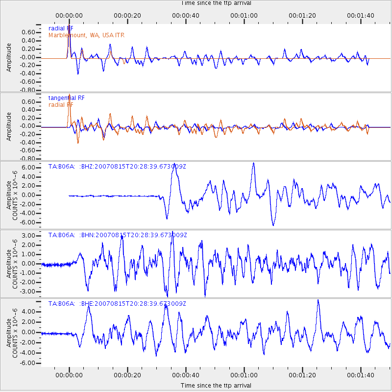
Earthquake location: Andreanof Islands, Aleutian Is.
Earthquake latitude/longitude: 50.3/-177.5
Earthquake time(UTC): 2007/08/15 (227) 20:22:11 GMT
Earthquake Depth: 9.0 km
Earthquake Magnitude: 6.3 MB, 6.2 MS, 6.4 MW, 5.9 ML
Earthquake Catalog/Contributor: WHDF/NEIC
Network: TA USArray Transportable Network (new EarthScope stations)
Station: B06A Marblemount, WA, USA
Lat/Lon: 48.52 N/121.48 W
Elevation: 75 m
Distance: 35.8 deg
Az: 70.632 deg
Baz: 294.557 deg
Ray Param: 0.07704021
Estimated Moho Depth: 10.5 km
Estimated Crust Vp/Vs: 2.04
Assumed Crust Vp: 6.566 km/s
Estimated Crust Vs: 3.215 km/s
Estimated Crust Poisson's Ratio: 0.34
Radial Match: 87.07212 %
Radial Bump: 400
Transverse Match: 59.739376 %
Transverse Bump: 400
SOD ConfigId: 2564
Insert Time: 2010-03-07 03:14:53.943 +0000
GWidth: 2.5
Max Bumps: 400
Tol: 0.001

Signal To Noise

ChannelStoNSTALTA
TA:B06A: :BHN:20070815T20:28:39.673009Z7.2532235.540086E-77.638102E-8
TA:B06A: :BHE:20070815T20:28:39.673009Z13.0123431.0139383E-67.792128E-8
TA:B06A: :BHZ:20070815T20:28:39.673009Z36.8153881.962398E-65.3303747E-8
Arrivals
Ps1.8 SECOND
PpPs4.5 SECOND
PsPs/PpSs6.3 SECOND