You are here: Home > Network List > TA - USArray Transportable Network (new EarthScope stations) Stations List
> Station B06A Marblemount, WA, USA > Earthquake Result Viewer
B06A Marblemount, WA, USA - Earthquake Result Viewer
| Earthquake location: |
Jujuy Province, Argentina |
| Earthquake latitude/longitude: |
-22.2/-65.8 |
| Earthquake time(UTC): |
2007/07/21 (202) 15:34:52 GMT |
| Earthquake Depth: |
290 km |
| Earthquake Magnitude: |
5.8 MB, 6.4 MW, 6.3 MW |
| Earthquake Catalog/Contributor: |
WHDF/NEIC |
|
| Network: |
TA USArray Transportable Network (new EarthScope stations) |
| Station: |
B06A Marblemount, WA, USA |
| Lat/Lon: |
48.52 N/121.48 W |
| Elevation: |
75 m |
|
| Distance: |
86.1 deg |
| Az: |
326.595 deg |
| Baz: |
129.856 deg |
| Ray Param: |
0.043542415 |
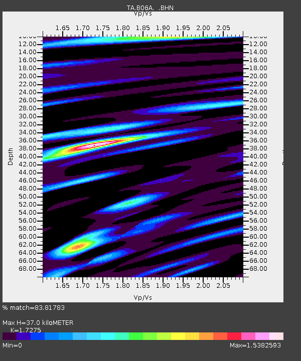
| Estimated Moho Depth: |
37.0 km |
| Estimated Crust Vp/Vs: |
1.73 |
| Assumed Crust Vp: |
6.566 km/s |
| Estimated Crust Vs: |
3.801 km/s |
| Estimated Crust Poisson's Ratio: |
0.25 |
|
| Radial Match: |
83.81783 % |
| Radial Bump: |
400 |
| Transverse Match: |
75.12602 % |
| Transverse Bump: |
400 |
| SOD ConfigId: |
2564 |
| Insert Time: |
2010-03-07 03:14:57.091 +0000 |
| GWidth: |
2.5 |
| Max Bumps: |
400 |
| Tol: |
0.001 |
|

Signal To Noise
| Channel | StoN | STA | LTA |
| TA:B06A: :BHN:20070721T15:46:30.024011Z | 1.6966246 | 1.7629264E-7 | 1.03907865E-7 |
| TA:B06A: :BHE:20070721T15:46:30.024011Z | 2.0373735 | 2.040216E-7 | 1.00139516E-7 |
| TA:B06A: :BHZ:20070721T15:46:30.024011Z | 6.209369 | 5.554267E-7 | 8.9449784E-8 |
| Arrivals |
| Ps | 4.2 SECOND |
| PpPs | 15 SECOND |
| PsPs/PpSs | 19 SECOND |


