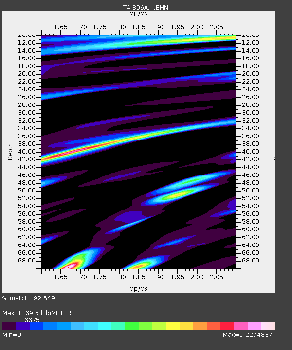
B06A Marblemount, WA, USA - Earthquake Result Viewer

Earthquake location: Near West Coast Of Honshu, Japan
Earthquake latitude/longitude: 37.5/138.4
Earthquake time(UTC): 2007/07/16 (197) 01:13:22 GMT
Earthquake Depth: 12 km
Earthquake Magnitude: 6.5 MB, 6.4 MS, 6.6 MW, 6.5 MW
Earthquake Catalog/Contributor: WHDF/NEIC
Network: TA USArray Transportable Network (new EarthScope stations)
Station: B06A Marblemount, WA, USA
Lat/Lon: 48.52 N/121.48 W
Elevation: 75 m
Distance: 68.9 deg
Az: 44.579 deg
Baz: 302.943 deg
Ray Param: 0.056027543
Estimated Moho Depth: 69.5 km
Estimated Crust Vp/Vs: 1.67
Assumed Crust Vp: 6.566 km/s
Estimated Crust Vs: 3.938 km/s
Estimated Crust Poisson's Ratio: 0.22
Radial Match: 92.549 %
Radial Bump: 400
Transverse Match: 91.20668 %
Transverse Bump: 400
SOD ConfigId: 2564
Insert Time: 2010-03-07 03:14:59.082 +0000
GWidth: 2.5
Max Bumps: 400
Tol: 0.001

Signal To Noise

ChannelStoNSTALTA
TA:B06A: :BHN:20070716T01:23:55.400029Z4.51756765.5216304E-71.2222574E-7
TA:B06A: :BHE:20070716T01:23:55.400029Z7.7454848.547733E-71.1035764E-7
TA:B06A: :BHZ:20070716T01:23:55.400029Z43.4308172.6425532E-66.084512E-8
Arrivals
Ps7.4 SECOND
PpPs27 SECOND
PsPs/PpSs34 SECOND