You are here: Home > Network List > TA - USArray Transportable Network (new EarthScope stations) Stations List
> Station B06A Marblemount, WA, USA > Earthquake Result Viewer
B06A Marblemount, WA, USA - Earthquake Result Viewer
| Earthquake location: |
Vanuatu Islands |
| Earthquake latitude/longitude: |
-15.4/168.6 |
| Earthquake time(UTC): |
2007/07/15 (196) 09:27:34 GMT |
| Earthquake Depth: |
8.0 km |
| Earthquake Magnitude: |
6.0 MB, 5.8 MS, 6.1 MW, 6.0 MW |
| Earthquake Catalog/Contributor: |
WHDF/NEIC |
|
| Network: |
TA USArray Transportable Network (new EarthScope stations) |
| Station: |
B06A Marblemount, WA, USA |
| Lat/Lon: |
48.52 N/121.48 W |
| Elevation: |
75 m |
|
| Distance: |
88.7 deg |
| Az: |
38.655 deg |
| Baz: |
244.989 deg |
| Ray Param: |
0.042421088 |
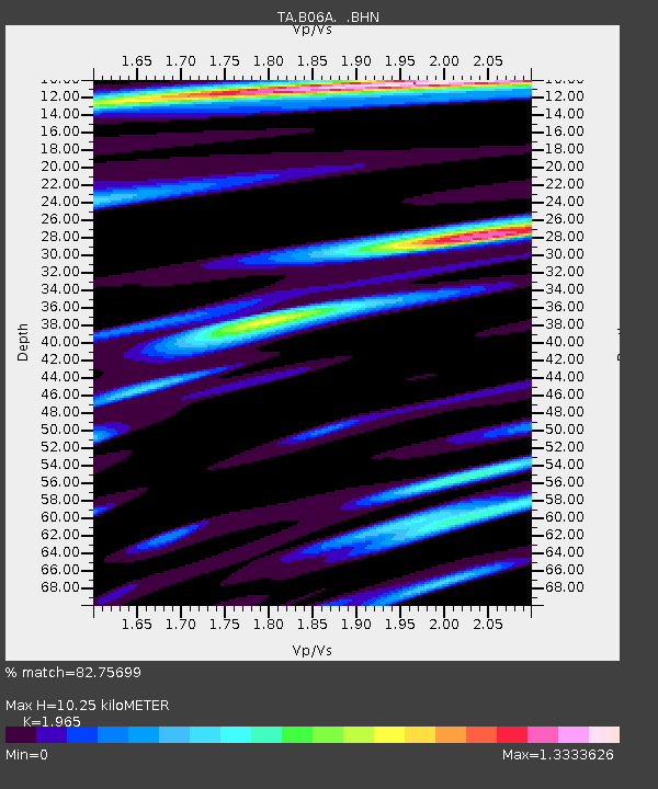
| Estimated Moho Depth: |
10.25 km |
| Estimated Crust Vp/Vs: |
1.97 |
| Assumed Crust Vp: |
6.566 km/s |
| Estimated Crust Vs: |
3.342 km/s |
| Estimated Crust Poisson's Ratio: |
0.33 |
|
| Radial Match: |
82.75699 % |
| Radial Bump: |
400 |
| Transverse Match: |
83.77982 % |
| Transverse Bump: |
400 |
| SOD ConfigId: |
2564 |
| Insert Time: |
2010-03-07 03:15:00.993 +0000 |
| GWidth: |
2.5 |
| Max Bumps: |
400 |
| Tol: |
0.001 |
|

Signal To Noise
| Channel | StoN | STA | LTA |
| TA:B06A: :BHN:20070715T09:39:56.599019Z | 3.8066187 | 2.9385885E-7 | 7.719682E-8 |
| TA:B06A: :BHE:20070715T09:39:56.599019Z | 4.7523675 | 4.1149332E-7 | 8.658702E-8 |
| TA:B06A: :BHZ:20070715T09:39:56.599019Z | 31.724146 | 1.8817288E-6 | 5.9315354E-8 |
| Arrivals |
| Ps | 1.5 SECOND |
| PpPs | 4.5 SECOND |
| PsPs/PpSs | 6.1 SECOND |


