You are here: Home > Network List > TA - USArray Transportable Network (new EarthScope stations) Stations List
> Station B06A Marblemount, WA, USA > Earthquake Result Viewer
B06A Marblemount, WA, USA - Earthquake Result Viewer

| Earthquake location: |
Solomon Islands |
| Earthquake latitude/longitude: |
-8.5/157.0 |
| Earthquake time(UTC): |
2007/04/01 (091) 20:39:56 GMT |
| Earthquake Depth: |
10 km |
| Earthquake Magnitude: |
6.8 MB, 7.9 MS, 8.1 MW, 7.7 ME |
| Earthquake Catalog/Contributor: |
WHDF/NEIC |
|
| Network: |
TA USArray Transportable Network (new EarthScope stations) |
| Station: |
B06A Marblemount, WA, USA |
| Lat/Lon: |
48.52 N/121.48 W |
| Elevation: |
75 m |
|
| Distance: |
90.7 deg |
| Az: |
41.115 deg |
| Baz: |
258.067 deg |
| Ray Param: |
0.041657094 |
| Estimated Moho Depth: |
38.5 km |
| Estimated Crust Vp/Vs: |
1.70 |
| Assumed Crust Vp: |
6.566 km/s |
| Estimated Crust Vs: |
3.874 km/s |
| Estimated Crust Poisson's Ratio: |
0.23 |
|
| Radial Match: |
96.067276 % |
| Radial Bump: |
400 |
| Transverse Match: |
88.09393 % |
| Transverse Bump: |
400 |
| SOD ConfigId: |
2564 |
| Insert Time: |
2010-03-07 03:15:13.420 +0000 |
| GWidth: |
2.5 |
| Max Bumps: |
400 |
| Tol: |
0.001 |
|
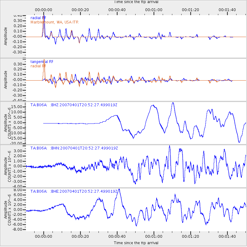
Signal To Noise
| Channel | StoN | STA | LTA |
| TA:B06A: :BHN:20070401T20:52:27.499019Z | 1.0497112 | 1.1891335E-7 | 1.13281956E-7 |
| TA:B06A: :BHE:20070401T20:52:27.499019Z | 4.494261 | 6.0292143E-7 | 1.3415362E-7 |
| TA:B06A: :BHZ:20070401T20:52:27.499019Z | 11.160364 | 1.7990066E-6 | 1.6119604E-7 |
| Arrivals |
| Ps | 4.2 SECOND |
| PpPs | 15 SECOND |
| PsPs/PpSs | 20 SECOND |


