You are here: Home > Network List > TA - USArray Transportable Network (new EarthScope stations) Stations List
> Station K06A Valley Falls, OR, USA > Earthquake Result Viewer
K06A Valley Falls, OR, USA - Earthquake Result Viewer

| Earthquake location: |
Near Coast Of Peru |
| Earthquake latitude/longitude: |
-14.3/-76.1 |
| Earthquake time(UTC): |
2007/08/16 (228) 05:16:56 GMT |
| Earthquake Depth: |
23 km |
| Earthquake Magnitude: |
5.8 MB, 6.1 MS, 6.3 MW, 6.2 ML |
| Earthquake Catalog/Contributor: |
WHDF/NEIC |
|
| Network: |
TA USArray Transportable Network (new EarthScope stations) |
| Station: |
K06A Valley Falls, OR, USA |
| Lat/Lon: |
42.80 N/120.25 W |
| Elevation: |
1340 m |
|
| Distance: |
69.7 deg |
| Az: |
326.893 deg |
| Baz: |
133.989 deg |
| Ray Param: |
0.05541702 |
| Estimated Moho Depth: |
15.25 km |
| Estimated Crust Vp/Vs: |
1.83 |
| Assumed Crust Vp: |
6.597 km/s |
| Estimated Crust Vs: |
3.615 km/s |
| Estimated Crust Poisson's Ratio: |
0.29 |
|
| Radial Match: |
88.57752 % |
| Radial Bump: |
400 |
| Transverse Match: |
82.0091 % |
| Transverse Bump: |
400 |
| SOD ConfigId: |
2564 |
| Insert Time: |
2010-03-07 03:15:32.254 +0000 |
| GWidth: |
2.5 |
| Max Bumps: |
400 |
| Tol: |
0.001 |
|
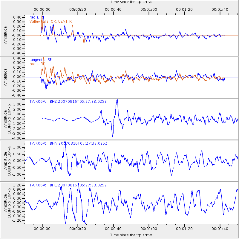
Signal To Noise
| Channel | StoN | STA | LTA |
| TA:K06A: :BHN:20070816T05:27:33.025Z | 0.9158711 | 1.3352589E-7 | 1.4579113E-7 |
| TA:K06A: :BHE:20070816T05:27:33.025Z | 0.49774894 | 1.636118E-7 | 3.2870346E-7 |
| TA:K06A: :BHZ:20070816T05:27:33.025Z | 2.8285031 | 6.8315484E-7 | 2.415252E-7 |
| Arrivals |
| Ps | 2.0 SECOND |
| PpPs | 6.3 SECOND |
| PsPs/PpSs | 8.3 SECOND |


