K06A Valley Falls, OR, USA - Earthquake Result Viewer
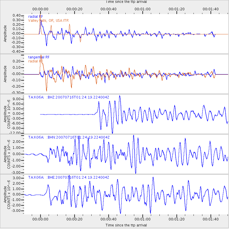
Earthquake location: Near West Coast Of Honshu, Japan
Earthquake latitude/longitude: 37.5/138.4
Earthquake time(UTC): 2007/07/16 (197) 01:13:22 GMT
Earthquake Depth: 12 km
Earthquake Magnitude: 6.5 MB, 6.4 MS, 6.6 MW, 6.5 MW
Earthquake Catalog/Contributor: WHDF/NEIC
Network: TA USArray Transportable Network (new EarthScope stations)
Station: K06A Valley Falls, OR, USA
Lat/Lon: 42.80 N/120.25 W
Elevation: 1340 m
Distance: 72.8 deg
Az: 49.078 deg
Baz: 305.303 deg
Ray Param: 0.053431235
Estimated Moho Depth: 69.75 km
Estimated Crust Vp/Vs: 1.61
Assumed Crust Vp: 6.597 km/s
Estimated Crust Vs: 4.111 km/s
Estimated Crust Poisson's Ratio: 0.18
Radial Match: 86.37823 %
Radial Bump: 400
Transverse Match: 85.09535 %
Transverse Bump: 400
SOD ConfigId: 2564
Insert Time: 2010-03-07 03:15:59.664 +0000
GWidth: 2.5
Max Bumps: 400
Tol: 0.001

Signal To Noise

ChannelStoNSTALTA
TA:K06A: :BHN:20070716T01:24:19.224004Z5.24799734.3133034E-78.2189516E-8
TA:K06A: :BHE:20070716T01:24:19.224004Z10.2572696.782787E-76.612664E-8
TA:K06A: :BHZ:20070716T01:24:19.224004Z33.2519842.4965027E-67.507831E-8
Arrivals
Ps6.7 SECOND
PpPs26 SECOND
PsPs/PpSs33 SECOND