You are here: Home > Network List > TA - USArray Transportable Network (new EarthScope stations) Stations List
> Station K06A Valley Falls, OR, USA > Earthquake Result Viewer
K06A Valley Falls, OR, USA - Earthquake Result Viewer
| Earthquake location: |
Solomon Islands |
| Earthquake latitude/longitude: |
-8.5/157.0 |
| Earthquake time(UTC): |
2007/04/01 (091) 20:39:56 GMT |
| Earthquake Depth: |
10 km |
| Earthquake Magnitude: |
6.8 MB, 7.9 MS, 8.1 MW, 7.7 ME |
| Earthquake Catalog/Contributor: |
WHDF/NEIC |
|
| Network: |
TA USArray Transportable Network (new EarthScope stations) |
| Station: |
K06A Valley Falls, OR, USA |
| Lat/Lon: |
42.80 N/120.25 W |
| Elevation: |
1340 m |
|
| Distance: |
90.4 deg |
| Az: |
46.892 deg |
| Baz: |
258.895 deg |
| Ray Param: |
0.041678097 |
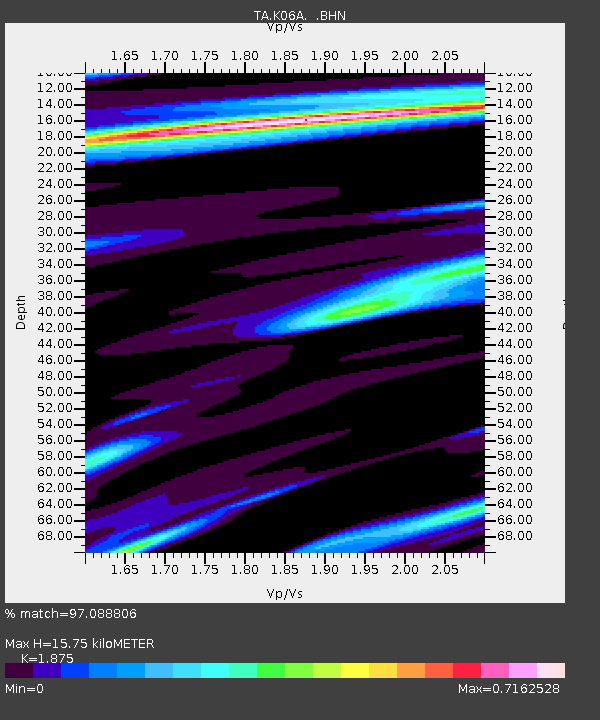
| Estimated Moho Depth: |
15.75 km |
| Estimated Crust Vp/Vs: |
1.88 |
| Assumed Crust Vp: |
6.597 km/s |
| Estimated Crust Vs: |
3.519 km/s |
| Estimated Crust Poisson's Ratio: |
0.30 |
|
| Radial Match: |
97.088806 % |
| Radial Bump: |
364 |
| Transverse Match: |
89.35445 % |
| Transverse Bump: |
400 |
| SOD ConfigId: |
2564 |
| Insert Time: |
2010-03-07 03:16:06.888 +0000 |
| GWidth: |
2.5 |
| Max Bumps: |
400 |
| Tol: |
0.001 |
|

Signal To Noise
| Channel | StoN | STA | LTA |
| TA:K06A: :BHN:20070401T20:52:26.124019Z | 0.61936575 | 1.1559579E-7 | 1.8663575E-7 |
| TA:K06A: :BHE:20070401T20:52:26.124019Z | 2.0924425 | 3.534465E-7 | 1.6891575E-7 |
| TA:K06A: :BHZ:20070401T20:52:26.124019Z | 11.737229 | 1.5235563E-6 | 1.2980544E-7 |
| Arrivals |
| Ps | 2.1 SECOND |
| PpPs | 6.7 SECOND |
| PsPs/PpSs | 8.9 SECOND |


