You are here: Home > Network List > TA - USArray Transportable Network (new EarthScope stations) Stations List
> Station K06A Valley Falls, OR, USA > Earthquake Result Viewer
K06A Valley Falls, OR, USA - Earthquake Result Viewer

| Earthquake location: |
Fiji Islands Region |
| Earthquake latitude/longitude: |
-16.5/177.0 |
| Earthquake time(UTC): |
2006/04/07 (097) 08:30:45 GMT |
| Earthquake Depth: |
22 km |
| Earthquake Magnitude: |
5.9 MB, 6.4 MS, 6.4 MW, 6.4 MW |
| Earthquake Catalog/Contributor: |
WHDF/NEIC |
|
| Network: |
TA USArray Transportable Network (new EarthScope stations) |
| Station: |
K06A Valley Falls, OR, USA |
| Lat/Lon: |
42.80 N/120.25 W |
| Elevation: |
1340 m |
|
| Distance: |
82.4 deg |
| Az: |
41.313 deg |
| Baz: |
239.352 deg |
| Ray Param: |
0.046862222 |
| Estimated Moho Depth: |
15.75 km |
| Estimated Crust Vp/Vs: |
1.67 |
| Assumed Crust Vp: |
6.597 km/s |
| Estimated Crust Vs: |
3.945 km/s |
| Estimated Crust Poisson's Ratio: |
0.22 |
|
| Radial Match: |
86.06651 % |
| Radial Bump: |
335 |
| Transverse Match: |
65.834274 % |
| Transverse Bump: |
400 |
| SOD ConfigId: |
2669 |
| Insert Time: |
2010-03-07 03:16:22.859 +0000 |
| GWidth: |
2.5 |
| Max Bumps: |
400 |
| Tol: |
0.001 |
|
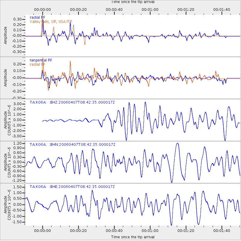
Signal To Noise
| Channel | StoN | STA | LTA |
| TA:K06A: :BHN:20060407T08:42:35.000017Z | 0.92730206 | 1.5803272E-7 | 1.7042204E-7 |
| TA:K06A: :BHE:20060407T08:42:35.000017Z | 0.72035044 | 1.9402655E-7 | 2.6935024E-7 |
| TA:K06A: :BHZ:20060407T08:42:35.000017Z | 3.965961 | 4.984121E-7 | 1.2567246E-7 |
| Arrivals |
| Ps | 1.7 SECOND |
| PpPs | 6.2 SECOND |
| PsPs/PpSs | 7.8 SECOND |


