You are here: Home > Network List > TA - USArray Transportable Network (new EarthScope stations) Stations List
> Station K06A Valley Falls, OR, USA > Earthquake Result Viewer
K06A Valley Falls, OR, USA - Earthquake Result Viewer

| Earthquake location: |
Near East Coast Of Kamchatka |
| Earthquake latitude/longitude: |
51.1/157.5 |
| Earthquake time(UTC): |
2006/08/24 (236) 21:50:36 GMT |
| Earthquake Depth: |
43 km |
| Earthquake Magnitude: |
5.9 MB, 6.2 MS, 6.5 MW, 6.5 MW |
| Earthquake Catalog/Contributor: |
WHDF/NEIC |
|
| Network: |
TA USArray Transportable Network (new EarthScope stations) |
| Station: |
K06A Valley Falls, OR, USA |
| Lat/Lon: |
42.80 N/120.25 W |
| Elevation: |
1340 m |
|
| Distance: |
53.9 deg |
| Az: |
64.42 deg |
| Baz: |
309.475 deg |
| Ray Param: |
0.06566153 |
| Estimated Moho Depth: |
17.5 km |
| Estimated Crust Vp/Vs: |
1.67 |
| Assumed Crust Vp: |
6.597 km/s |
| Estimated Crust Vs: |
3.945 km/s |
| Estimated Crust Poisson's Ratio: |
0.22 |
|
| Radial Match: |
93.309425 % |
| Radial Bump: |
374 |
| Transverse Match: |
86.704636 % |
| Transverse Bump: |
400 |
| SOD ConfigId: |
2665 |
| Insert Time: |
2010-03-07 03:16:39.690 +0000 |
| GWidth: |
2.5 |
| Max Bumps: |
400 |
| Tol: |
0.001 |
|
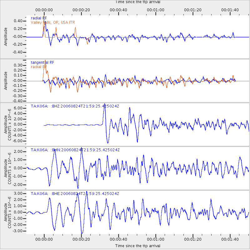
Signal To Noise
| Channel | StoN | STA | LTA |
| TA:K06A: :BHN:20060824T21:59:25.425024Z | 12.416541 | 9.0325403E-7 | 7.2746026E-8 |
| TA:K06A: :BHE:20060824T21:59:25.425024Z | 12.386692 | 1.144113E-6 | 9.236631E-8 |
| TA:K06A: :BHZ:20060824T21:59:25.425024Z | 49.160923 | 4.0291375E-6 | 8.1958135E-8 |
| Arrivals |
| Ps | 1.9 SECOND |
| PpPs | 6.7 SECOND |
| PsPs/PpSs | 8.6 SECOND |


